Shallow-Water Wave Calculator
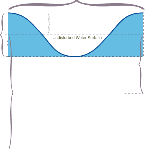
Deep-Water Significant Wave (Hs) Characteristics
About this toolAbout Deep-Water Significant Wave Characteristics
This tab displays approximations of various deep-water wave characteristics, including:
- Wavelength
- Wave Height spectrum for significant (Hs or H1/3), H1/10, H1/100, and maximum expected value.
- Significant wave amplitude
- Significant wave steepness
- Wave velocity and group velocity
- Transition zone and shallow-water zone starting depths
How to use this tool
To obtain the above approximations, enter the wave period and significant height into their respective input boxes above and click Calculate.
The values calculated on this tab are used to generate all the other estimations shown on the subsequent tabs. Click the tab headers to view their information displays.
All of these processes are presented and described in more detail in COMET's companion lesson, Shallow-Water Waves (http://meted.ucar.edu/marine/SWW/).
Wave Attenuation Estimator
About this toolAbout the Wave Attenuation Estimator
This tool can be used to make rough estimates of the attenuated heights of waves that travel significant distances over areas of gently sloped bathymetry. Attenuation effects are greatest for long-period waves traveling over extended shallow slopes. This estimator calculates attenuation for a generic bathymetry slope, which may not always be the most appropriate choice for a given coastal area and wavelength. If your area of interest does not have relatively even and gradual bathymetry slope throughout the transition and shallow water zones, the estimations produced by this calculator are likely to be inaccurate.
How to Use this Tool
To use the wave attenuation estimator, follow these steps:
- Enter the bathymetry slope for your shallow-water area of interest. Then click Predict. If you're not sure what zone to choose, try the bathymetry slope over the area between your incoming wave's shallow-water starting depth (L/20) up to the breaker zone.
- Attenuated significant wave heights are calculated. You can compare these with deep-water significant wave heights. Then, you can enter the resulting attenuated significant wave heights into the input box above to estimate shoaling, refraction, and other effects for attenuated waves, once they reach the beach.
- Results are not computed if the slope is too steep (>= 0.1).
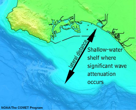
Assuming average bottom roughness, you can use this tool to make very rough estimates of attenuated significant heights for waves traveling over an extended stretch of shallow water. An example of such a location is the shelf area shown below, which extends outward from Long Beach, CA. Note that this tool provides only crude estimates, and you could likely obtain better results by comparing statistical records of deep water waves to observed breaker heights for your coastal area of interest.
Note: Now that you have calculated the significant attenuated wave height, enter this value as the Significant Height above to estimate shoaling, refraction, and the other coastal effects for attenuated waves instead of deep-water waves.
What is the bathymetry slope over your shallow-water area of interest?
Directions: Enter the bathymetry slope over the shallow-water zone for which you want to estimate attenuation, then click Predict. This zone is wavelength-dependent, and would normally extend from the start of the shallow-water zone up to the breaker zone. Attenuation is not calculated for slopes of 0.1 (1:10 ) and steeper (valid slope range: 0 - 0.099).
Shoaling Effect Estimator
About this toolAbout the Shoaling Effect Estimator
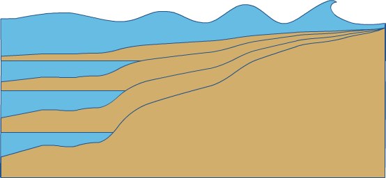
Shoaling is the process through which wave heights increase as water depth decreases. As waves enter shallow water and the water depth begins to decrease, the base of the incoming wave begins to experience frictional drag, causing both wave velocity and wavelength to decrease. Since wave period is always conserved, wave height must increase as wavelength shortens. As the wave energy becomes concentrated into a narrower and slower moving band, the wave height continues to grow until it becomes unstable and finally breaks.
This tab displays estimations of shoaling breaker heights for:
- Four generic beach slopes, ranging from 0.020 (a 1:50 ratio) to 0.100 (a 1:10 ratio)
- Spectrum of shoaling breaker heights for significant (Hs or H1/3), H1/10, H1/100, and Hmax
The shoaling factor data source: Goda, Y. 1970. "A Synthesis of Breaker Indices," Transactions of the Japan Society of Civil Engineers, Vol 2, Part 2, pp 227-230.
Shoaling is dependent on both deep-water wave steepness and beach slope. The breaker steepness can be used to find the estimated depth of breaking on the Breaking Depth Nomogram.
| Significant Wave (Hs) Approximations | |||
|---|---|---|---|
| Shoaling Factor | Shoaling Breaker Height | Breaker Steepness | |
| Gentle Beach (1:50 slope) | |||
| Moderate Beach (1:33 slope) | |||
| Average Beach (1:20 slope) | |||
| Steep Beach (1:10 slope) | |||
Breaker Height Spectrum on a Moderate Beach (1:33 slope)
Refraction Effect Estimator (for points & headlands)
About this toolAbout the Refraction Effect Estimator
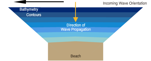
This tool can be used to estimate the refraction effect for shoaling breakers at the points of symmetrical bathymetry features. However there are several important limitations:
- The direction of wave propagation must be perpendicular to the bathymetry slope extending from the point or headland.
- This tool provides estimations only for angles of refraction up to 40°.
How to Use this Tool
To use the refraction effect estimator, follow these steps:
- Enter the wave period and significant height into the input boxes above and click Calculate.
- Use the Angle of Refraction input box or slider to approximate the bathymetry contours surrounding the point or headland of interest.
- Refracted breaker heights are calculated based on estimated shoaling breaker heights given on the Shoaling Tab.
0°
Significant Wave (Hs) Approximations
| Beach Slope: | |
| Shoaling Breaker Height | |
| Refraction Coefficient | |
| Refracted Shoaling Breaker Heights |
Breaker Height Spectrum
| Hs | |
| H1/10 | |
| H1/100 | |
| Hmax |
Breaker Type Predictions
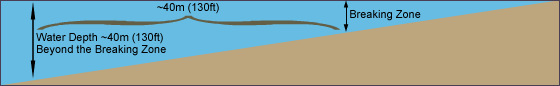
Expected breaker type is dependent on the approximate bathymetry slope over a distance of ~40 meters leading up to the significant wave breaking depth. Enter the approximate water depth in the area roughly 40 m (130 ft) beyond the expected breaker zone into the box below, then click Predict.
About this toolAbout Breaker Types
The manner in which a wave breaks depends on the wave's depth with respect to the bathymetry. There are 4 basic types of breaking waves: spilling, plunging, surging, and collapsing, but the first two, spilling and plunging, are by far the most important for forecasting purposes.
- Spilling breakers occur in areas with gradual, gently sloped bathymetry. The depth at which a spilling wave will begin to break is approximately 1.67H where H is the height at breaking.
- Plunging breakers occur when the wave moves abruptly from deep to shallow water. The base of the wave decelerates rapidly, while the top of the wave continues moving at its original speed. With this large speed differential, the top of the wave pitches out in front, forming a curl or tube. This type of breaker can also cause much more beach erosion than other types.
- Surging breakers occur along stretches of coastline where there is no shoaling zone due to extremely rapid drop-offs. Deep water waves never break before reaching land. Instead, the water just pushes or surges up onto the beach.
- Collapsing breakers occur with very small, short-period waves, which shoal and collapse right onto the beach. These breakers are operationally insignificant because they are so small and pose negligible hazard.
How to Use this Tool
To obtain predictions of expected breaker type for a given bathymetry slope, enter the water depth in the area roughly 40 meters or 130 feet (lateral distance) beyond or seaward of the breaking zone and click Predict.
| Depth of Breaking | |
| Water Depth ~40m (130ft) Beyond the Breaking Zone |
-- |
| Bottom Slope | |
| Deep-water Wave Steepness | |
| Breaker Type Coefficient (E) | |
| Predicted Breaker Type |

Wave Set-up Estimator
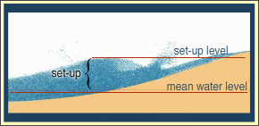
Wave set-up is the water rise at the coast due to the action of waves breaking on the beach. The return flow of white water from waves that have broken is much slower than the speed of incoming waves, resulting in a piling up of water in the surf zone as wave action continually forces water up onto the beach.
The height or magnitude of wave set-up can be approximated from the breaking wave height, and can be a significant contributing factor to coastal flooding caused by large swell emanating from hurricanes and nor'easters.
Because there is so much variation in beach slope, composition, and configuration, set-up can only be roughly approximated, but it is still an important factor to consider when forecasting coastal flooding.
| Shoaling Breaker Height | |
| Wave Set-up |
Roll your cursor over the terms to see the formulas used to generate them.
Linear estimations in FEET. Velocity estimates in knots.
Produced by the COMET® Program