Communications Simulation
This simulation will give you a chance to apply what you already know about communicating fire weather information to National Weather Service (NWS) partners. You will take the role of a NWS meteorologist communicating fire weather information to a Fire Operations Chief via a teleconference. Your partner’s reaction and decisions will change based on your selections.
There are three questions in this simulation. To complete the simulation successfully, you will need to select the correct answer for all three questions. Feedback is available only after you complete the simulation. You will have three attempts to complete the simulation successfully. Launch the simulation when you are ready.
Scenario: In July, drought and lightning strikes have led to a number of large fires across northwest California and southwest Oregon. Thousands of firefighters and multiple Incident Management Teams are deployed across the region, and resources are stretched thin. It is August, and for a second time this month, thunderstorms are forecast to roll through the region as a small cut-off low lingers off the California coast.
You are a forecaster in the Medford, Oregon Weather Forecast Office (WFO) and you are working with 5 Incident Meterologists (IMETs) on various fires, and a couple of Type II teams that do not have IMETs assigned to them yet. One of those Type II fires without an IMET is the Little Deer fire in Siskiyou County, California.
An earlier call with the IMETs revealed that they are frustrated by the inability to use the models to develop a sense of timing or intensity for the thunderstorms. The firefighters are very worried about control issues due to erratic winds. The HRRR model guidance indicates thunderstorms developing between 16:00 and 18:00 PDT. The Storm Prediction Center has a general risk of convection for the day. One limiting factor is that recent thunderstorms have tempered fuels with the humidity not much below 30%, so you do not expect many new fire starts. The weather could be a problem for existing fires, but the risk for starting new fires is low.
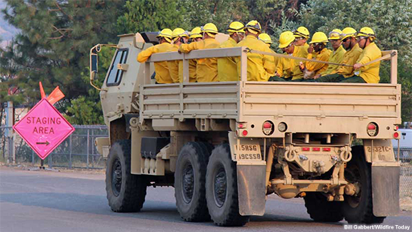
You receive a call from an Operations Section Chief at the Little Deer fire. The Operations Chief explains that they have National Guard troops in the field fighting the fire. Their main operational constraint is that their vehicles are not enclosed in the back, just tarped. If a thunderstorm develops, their only option is to disengage 90 minutes ahead of any storms to drive back to Yreka. This will limit the risk that the troops will be struck by lightning, either on the line or in the back of the trucks. This also limits how far they are going to let the troops hike off the roads without adding too much time to their 90 minute window.
Launch SimulationCommunication Simulation
Attempt # of 3
Scenario
In July, drought and lightning strikes have led to a number of large fires across northwest California and southwest Oregon. Thousands of firefighters and multiple Incident Management Teams are deployed across the region, and resources are stretched thin. It is August, and for a second time this month, thunderstorms are forecast to roll through the region as a small cut-off low lingers off the California coast.
You are a forecaster in the Medford, Oregon Weather Forecast Office (WFO) and you are working with 5 Incident Meterologists (IMETs) on various fires, and a couple of Type II teams that do not have IMETs assigned to them yet. One of those Type II fires without an IMET is the Little Deer fire in Siskiyou County, California.
An earlier call with the IMETs revealed that they are frustrated by the inability to use the models to develop a sense of timing or intensity for the thunderstorms. The firefighters are very worried about control issues due to erratic winds. The HRRR model guidance indicates thunderstorms developing between 16:00 and 18:00 PDT. The Storm Prediction Center has a general risk of convection for the day. One limiting factor is that recent thunderstorms have tempered fuels with the humidity not much below 30%, so you do not expect many new fire starts. The weather could be a problem for existing fires, but the risk for starting new fires is low.
You receive a call from an Operations Section Chief at the Little Deer fire. The Operations Chief explains that they have National Guard troops in the field fighting the fire. Their main operational constraint is that their vehicles are not enclosed in the back, just tarped. If a thunderstorm develops, their only option is to disengage 90 minutes ahead of any storms to drive back to Yreka. This will limit the risk that the troops will be struck by lightning, either on the line or in the back of the trucks. This also limits how far they are going to let the troops hike off the roads without adding too much time to their 90 minute window.
Locations
Tab 2 Content
Question 1.

The HRRR model guidance indicates thunderstorms developing between 16:00 and 18:00 PDT. The Storm Prediction Center has a general risk of convection for the day. One limiting factor is that recent thunderstorms have tempered fuels with the humidity not much below 30%, so you do not expect many new fire starts. The weather could be a problem for existing fires, but the risk for starting new fires is low. To view the full scenario click the “Data” link above.
The Operations Chief’s main question when he calls at 10:30 PDT for you is “What will the weather do today?”
Which of the following statements will you choose to best communicate the expected weather situation?
Question 2.
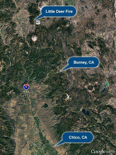
You have continued monitoring the situation for the last few hours. The latest HRRR model guidance shows thunderstorms developing between 16:00 and 18:00 PDT and staying mainly to the east of the fire. A recent IMET sounding shows the Lifted Index (LI) is already approaching -4 in Burney, CA and lightning has been detected near Chico from thunderstorms which have mostly been along the Sierra Crest all morning.
At 11:30 PDT, the Operations Section Chief from the Little Deer fire calls again. “The last time we spoke, you said that the storms could develop in the late afternoon today. Is that timing still correct? Where will the storms be in relation to the fire? How confident are you in the forecast?”
Question 2.
You have continued monitoring the situation for the last few hours. The latest HRRR model guidance shows thunderstorms developing between 16:00 and 18:00 PDT and staying mainly to the east of the fire. A recent IMET sounding shows the LI is already approaching -4 in Burney, CA and lightning has been detected near Chico from thunderstorms which have mostly been along the Sierra Crest all morning.
At 11:30 PDT, the Operations Section Chief from the Little Deer fire calls again. “The last time we spoke, you were pretty sure that thunderstorms will develop today. But, you and other IMETs were arguing about the timing. I hope you sorted it out and have better timing information for me? Also, where will the storms be in relation to the fire? How confident are you in the forecast?
Question 2.
You have continued monitoring the situation for the last few hours. The latest HRRR model guidance shows thunderstorms developing between 16:00 and 18:00 PDT and staying mainly to the east of the fire. A recent IMET sounding shows the LI is already approaching -4 in Burney, CA and lightning has been detected near Chico from thunderstorms which have mostly been along the Sierra Crest all morning.
At 11:30 PDT the Operations Section Chief from the Little Deer fire calls again. “The last time we spoke, the Storm Prediction Center told you there was a low chance of storms today. You did not think the lightning threat was an issue for starting new fires, so you were holding off on the Red Flag Warning. How confident are you in that forecast? What happened with the model that was showing some thunderstorms? Does it give you some timing information you can share? Also, if the storms happen, where will they be in relation to the fire?
Question 3.
The Operations Sections Chief follows up with this question “So, you are fairly confident that the storms will most likely arrive around 16:00 but there is a chance they could impact the fire sooner. What will be the main impacts?”
Question 3.
The Operations Sections Chief follows up with this question “So, you made me wait an hour and you are still not sure when the storms will get over the fire. The model is telling you at 16:00, but some IMET balloon is telling you 13:00, and you believe it. This makes it harder to figure out what to tell my crews. I don’t think they will go for the balloon part to be honest. Do you at least have an idea of what will be the main impacts?”
Question 3.
The Operations Sections Chief follows up with this question “I waited an hour for you and the best you can do is tell me what is happening at Burney and Chico. I don’t really care what is happening there. I need to know what will be the situation over the Little Deer fire. You sound pretty sure that thunderstorms will reach the fire today sometime between noon and 18:00. That is a pretty big time window and is not helping me plan the work or what to tell my crews. Can you at least tell me what will be the main impacts?”