Univ. of Oklahoma: "Evolution of warm-season MCS activity over the Great Plains
during late-morning hours: Insights into short-term forecasting"
Final
Report
SECTION
1: PROJECT OBJECTIVES AND ACCOMPLISHMENTS
A cooperative effort among the University of Oklahoma School of Meteorology,
National Weather Service offices in Norman, OK and Dodge City, KS, and the NOAA/National
Severe Storms Laboratory (NSSL), “The Morning Convection Project”
was formally begun in January 2000. A primary objective of the project has been
the development of tools that can be used to aid in forecasting the evolution
of mesoscale convective systems (MCSs) that affect the Great Plains during summer
late-morning hours.
One of the first activities of the project was to attempt to better understand
what factors are currently thought to be most important by forecasters in predicting
the evolution of MCSs during this period of the day. This task was taken on
by the forecasters at Norman and Dodge City, who recorded in real time (via
a web site) their comments on factors that they relied on in making a 4-8 hour
forecast of the evolution of 37 MCSs that occurred during the summers of 1997
to 2000. Another specific activity was the development of a climatology to provide
enhanced knowledge of many aspects of these systems. Among the key questions
to be addressed was the actual distribution of evolution behaviors during this
period of the day. This activity was carried out primarily by graduate student
John Haynes (with COMET support), who documented the tracks, evolution, initiation
mechanisms and locations, and other attributes of 145 MCSs that fit specific
criteria during the 1996-2000 summers. The Norman NWS office was actively involved
in this also through providing knowledge of software and hardware for accessing
radar and other types of data needed for the climatology. A third activity involved
relating environmental factors to the observed evolution of a subset of the
MCS cases. Analyses from the Rapid Update Cycle-2 (RUC-2) Model were used to
characterize the environment ahead of the 48 systems that occurred during the
summers of 1999 and 2000. This activity was carried out primarily by graduate
student John Haynes with support from NSSL and the Storm Prediction Center for
programming and data acquisition and processing.
a. Forecaster exercise
Climatologies carried out in the past have emphasized the nocturnal maximum
of MCS activity over the Great Plains and have implied that these systems usually
dissipate or decrease in intensity by late morning. This late morning evolutionary
tendency has been learned by forecasters and researchers as they experience
the characteristics of these systems. Results of the forecaster exercise reinforce
the existence of this mindset. Of the 37 systems included in the exercise 78%
were forecast to either decrease in intensity or dissipate during the late morning,
and the knowledge that they do often decrease or dissipate was listed as an
important factor in making the forecast a significant percentage of the time.
The primary factor relied upon by forecasters in the exercise was extrapolation
of current trends seen in radar and satellite data. Other factors listed often
were stability and wind characteristics of the environment into which the system
was moving and whether or not the system was moving with an upper-level feature.
b. Climatology
The 5-year climatology of morning systems was restricted to those that affected
the county warning areas of the Norman and Dodge City NWS Offices during the
0900-1700 UTC period. In addition systems included in the data set had to satisfy
criteria related to size, motion, duration, intensity, and occurrence of lightning.
The initiation locations of the systems included in the climatology are shown
in Figure 1. It can be seen that the majority of these morning systems were
initiated in Colorado or New Mexico on the previous afternoon. Favored areas
were along the Palmer Ridge in east-central Colorado and along the Raton Mesa
near the Colorado-New Mexico border. The median direction of system motion was
from the west-northwest; moreover, 69% of cases fell in the 270-320? sector.
Attesting to the severity of weather accompanying MCSs in the study, there were
940 severe reports attributed to these systems within the combined Norman and
Dodge City CWAs. About 60% of these were wind damage reports, 30% hail, and
about 10% either flood damage, lightning damage, or tornado reports. The evolutionary
tendency of each system was also documented for the 13-17 UTC period (late morning).
It was found that 72% of systems either decreased or dissipated, while 28% either
remained at about the same intensity or increased during the period. These finding
quantitatively verify the perception that most summer systems in this area decrease
in intensity or dissipate during this period of the day. From the NWS point
of view the climatology provides a basis for forecast decisions and serves as
a training tool to acquaint new NWS forecasters to weather regimes in the area.
c. Environmental influences
A number of approaches were used to determine environmental influences on
the evolution of observed systems during the late morning. The distribution
of evolutionary tendencies for systems that were perceived to move in tandem
with synoptic features was compared with the distribution for all systems in
the climatology. Virtually no difference was found in the distribution of tendencies
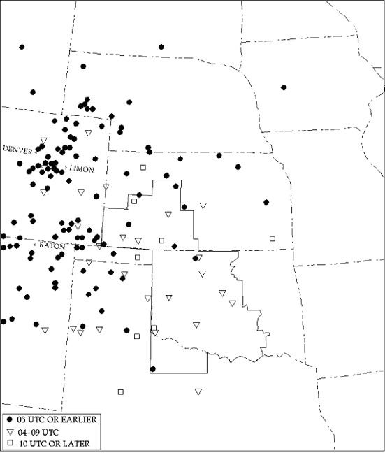
Figure 1. Initiation locations for the MCSs that were included
in the climatology.
The key at lower left indicates the time period of initiation for the location
markers.
The area bounded by the solid line encloses the county warning areas of the
Dodge City and Norman NWS offices.
for these 52 systems when compared with the distribution for the entire data
set. This finding is important because it says that MCS movement in tandem with
a synoptic feature is not a reliable indicator that the system will be sustained.
A major thrust of the project was to investigate wind and stability factors
in the environment of these MCSs to determine influences of these factors on
system evolution. Because observational density of these environmental parameters
in both time and space is lacking, it was decided to use RUC-2 analyses to provide
the desired information. This part of the study had to be limited to 48 systems
that occurred in 1999 and 2000 because of significant changes in the RUC analysis
input data between the summers of 1998 and 1999.
One approach to using these data was to construct composite soundings for
two classes of systems. Soundings were obtained from the RUC analyses in every
case 50 km ahead of the observed system’s leading edge location. The composites
were constructed at 15 UTC for systems that: (a) showed a steady (including
a few increasing cases) evolutionary tendency (16 systems), and (b) showed a
decreasing (including dissipation) tendency (32 systems) in the 13-17 UTC period.
The composites showed that cases in the steady class existed in environments
with larger CAPE, less negative CINH, and more negative lifted index than cases
in the decreasing class. System-relative wind profiles in the plane of system
motion were calculated for all cases in the two evolution classes. System-relative
inflow was slightly larger for the steady class composite, while vertical wind
shear in the two composite profiles was very similar. The relationship of the
magnitude of most of these parameters to evolution in the two classes is that
which one would expect; however, to evaluate their usefulness as discriminators
of classes of evolution requires examining individual cases.
If the values of parameters (e. g., CAPE, lifted index, or vertical wind shear
over various depths) are compared on a case-by-case basis with evolutionary
tendencies, the result is generally that extreme values of the parameters correlate
well with either the steady or decreasing class of evolution. However, there
are a significant number of moderate parameter values that occur with either
of the two classes. Therefore the parameters are of limited value as predictive
tools. It was found, however, that if pairs of parameters are compared with
evolution classes, discrimination between the classes of evolution is improved.
As an example, in Figure 2 each of the 48 cases is plotted as a function of
the lifted index and 0-2 km vertical wind shear at 15 UTC from RUC-2 soundings
50 km ahead of that system. To the right of the solid line 17 0f 18 (94%) cases
are in the decreasing class. If the division is shifted to the left to include
more cases (dashed line), 22 of 26 (85%) cases are in the decreasing class.
Results of the climatology have shown that a decrease in evolution will occur
72% of the time; therefore, confidence in a decreasing forecast in this parameter
range can be increased. Similar analyses involving combinations of these parameters
with others (CAPE, 0-10 km vertical wind shear) have yielded similar results.
From the NWS point of view these results have identified forecast tools found
most effective in forecasting these systems, and the potential for more advances
is present. A follow-on project to include other parameters is planned.
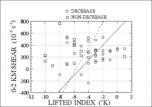
Fig.2 Scatter plot showing each of the 48 MCSs as a function
of lifted index and 0-2 km
vertical
wind shear derived from RUC-2 soundings at 15 UTC in the system environment.
Circles are from the decreasing evolution class while squares are from the
steady (non-decreasing) class. See text for explanation of superimposed lines.
A major effort was also made to
relate changes in environmental parameters over the 13-17 UTC period with the
observed system evolution during the same time frame. Parameters that were examined
as a part of this task included CAPE, CINH, lifted index, vertical shear calculated
over seven different layers, low-level mass flux into the system over three
surface-based depths, and water vapor flux into the system over two surface-based
depths. Changes in most parameters conformed to expected relation to system
evolution more than 50% of the time (e.g., decreasing CAPE was associated with
decreasing system intensity 67% of the time), but no relationship was sufficiently
strong to improve upon the use of climatology. It is, however, possible that
combinations of parameter changes will be useful in increasing confidence in
certain cases. The follow-on project will investigate this issue also.
d. A surprising lesson
learned
Prior to utilizing RUC-2 analysis soundings as proxies for observed soundings,
direct comparisons were made between NWS rawinsonde observations and RUC-2 soundings
interpolated to Norman, Oklahoma and several other operational observing sites.
This comparison showed that RUC-2 temperature, moisture, and wind direction
profiles agreed reasonably well with corresponding rawinsonde observations.
However, a serious problem was found in low-level wind speeds derived from the
RUC analysis soundings. In cases where a low-level jet was present the RUC consistently
underestimated the wind speeds at jet level and located the jet higher above
the surface than observed. A typical example of a comparison for one of the
low-level jet cases at Norman, Oklahoma is shown in Figure 3. A number of potential
reasons for this
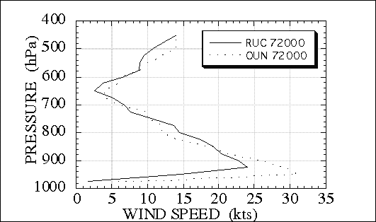
Figure 3. Comparison of wind speed (kts) profiles from Norman
rawinsonde
ascent (dotted) and RUC-2 analysis (solid) interpolated to Norman location
on 20 July 2000 at 12 UTC.
problem have been proposed and are
being investigated jointly with personnel from the Forecast Systems Laboratory.
The overall effects of this inconsistency on results of this study are unknown.
Potentially, derived low-level wind shear and low-level mass and water vapor
flux are affected. This information is important to anyone using RUC low-level
wind information in real time and for others who utilize data from the archive.
For NWS forecasters the knowledge that the RUC consistently under forecasts
the intensity of the low-level jet is quite significant, since adverse impacts
on forecasts of shear, moisture advection, and temperature advection would result.
SECTION 2: SUMMARY OF UNIVERSITY-NWS EXCHANGES
A meeting of all major participants
was held during the second month of the project, including representatives from
the two NWS offices, the University of Oklahoma, and NSSL, where initial plans
for the project were outlined. Graduate student J. Haynes was provided a workstation
(SAC) in the NWS Norman office located in the middle of the forecast area, where
he benefited from learning about operation of the office and interaction with
forecasters. NWS personnel also aided in technical aspects of acquiring and
displaying data needed for the study. The NWS Storm Prediction Center has also
been helpful in providing access to archived data sets. A key link as well came
through the forecaster exercise (mentioned above) that spanned four summers.
C. Hane traveled to Dodge City in the summer of 2000 to brief the new SOO, E.
Berry, on the project. Graduate student J. Haynes spent 2 weeks during the same
summer at the Dodge City office gaining additional perspective on operation
of a forecast office, acquainting forecasters with the project, and benefiting
from learning from the forecasters both during MCS events and at other times.
A meeting of J. Haynes’ M.S.
Committee early in 2001 at the University of Oklahoma to approve plans for his
thesis work also included NWS personnel who made valuable suggestions for carrying
out his research. Mr. Haynes presented a summary of his work to date in March
2001 at the NWS Norman’s Spring Convective Workshop. This meeting was
attended by many NWS Norman staff and additionally by employees of the Radar
Operations Center, the National Severe Storms Laboratory, the Storm Prediction
Center, and other local weather facilities. University and NWS partners jointly
prepared and authored a paper for the Ninth Conference on Mesoscale Processes,
and Mr. Haynes presented a poster at the conference. Smaller versions of this
poster were produced for display at both NWS offices. Mr. Haynes and C. Hane
visited the NWS office in Dodge City in September 2001 where Mr. Haynes made
a presentation summarizing work to date. During the visit participants discussed
future plans for the project and reviewed data from a western Kansas tornado
outbreak that occurred in the early spring of 2001 and was a difficult situation
from a warning perspective. Mr. Haynes wrote a technical attachment summarizing
work to date for the November 2001 issue of NWS Southern Topics. In the late
spring of 2002 both NWS and university representatives attended a seminar by
J. Haynes at the University of Oklahoma summarizing the results of his thesis
research.
SECTION 3: PRESENTATIONS AND PUBLICATIONS
a. Presentations
C. Hane presented a poster in
January 2000 at the AMS 15th Conference on Hydrology in Long Beach, CA, summarizing
preliminary work and plans for the project.
J. Haynes made a presentation
at the NWS Norman Spring Workshop in March 2001 on current results of his
research.
J Haynes presented a poster
at the AMS 9th Conference on Mesoscale Processes in August 2001 in Ft. Lauderdale,
FL on results of his research to date.
J. Haynes presented a talk at
the Dodge City NWS Office in September 2001 on results of his research to
date.
R. Rabin presented a paper at
the 11th Conference on Satellite Meteorology in Madison, WI in October 2001
that included cases from the project climatology, and with C. Hane and J.
Haynes as co-authors.
J. Haynes presented a seminar
at the University of Oklahoma in May 2002, summarizing final results of his
thesis research.
J. Haynes presented a talk preceding
his successful thesis defense at the University of Oklahoma in June 2002,
summarizing results of his thesis work
b. Publications
Hane, C.E., D.L. Andra, Jr.,
S.M. Hunter, F.H. Carr, R.M. Rabin, and J.C. Derby, 2000: Evolution of warm-season
heavy rain systems over the Great Plains during late-morning hours. Preprints,
15th Conf. on Hydrology, Long Beach, CA, Amer. Meteor. Soc., 176-179.
Haynes, J.A., C.E. Hane, D.L.
Andra, Jr., E. Berry, F.H. Carr, and R.M. Rabin, 2001: Analysis of warm-season
morning convection across the southern Great Plains. Preprints, Ninth Conf.
On Mesoscale Processes, Ft. Lauderdale, FL, Amer. Meteor. Soc., 434-438.
Rabin, R.M., J. Brunner, C.E.
Hane, and J.A. Haynes, 2001: Water vapor winds in vicinity of convection and
winter storms. Preprints, Eleventh Conf. On Satellite Meteor. and Oceanography,
Madison, WI, Amer. Meteor. Soc., 252-255.
Haynes, J. A., C. E. Hane, D.
L. Andra, Jr., E. Berry, F. H. Carr, and R. M. Rabin, 2001: Analysis of warm-season
morning convection across the southern great plains. Southern Region Notes,
November 2001.
Haynes, J.A., 2002: Analysis
of warm season morning convection across the southern Great Plains. M.S. Thesis,
University of Oklahoma, 119 pp.
Rabin, R. M., J. Brunner, C.
E. Hane, and J. A. Haynes, 2003: Water vapor winds in the vicinity of convection
and winter storms. Bull. Amer. Meteor. Soc., 84 (conditionally accepted).
Hane, C. E., J. D. Watts, D.
L. Andra, Jr., J. A. Haynes, E. Berry, R. M. Rabin, and F. H. Carr, 2003:
The evolution of morning convective systems over the Great Plains during the
warm season. Part I: The forecast problem. Wea. Forecasting, 18 (submitted).
A second paper entitled “The
Evolution of Morning Convective Systems over the Great Plains during the
Warm Season. Part II: A Climatology and Environmental Influences” will
be submitted to Weather and Forecasting with J. Haynes as lead author summarizing
the significant results of his thesis research. Co-authors will be the same
as in Item 7, but reordered.
SECTION 4: SUMMARY OF BENEFITS AND
PROBLEMS ENCOUNTERED
a. Benefits to academic participants
Graduate student J. Haynes gained
new understanding of forecast problems relevant to his own research as well
as other problems by having his work area in the midst of the forecast area
in Norman and by his extended summer visit to the office in Dodge City. This
arrangement afforded him many opportunities for exposure to operational forecasting
techniques. In the two offices he learned to access new data sources such as
current information available on AWIPS as well as archived data through use
of software made available on workstations. He has also benefited from technical
guidance from NWS personnel concerning such tasks as how to access, process,
and store data. Additionally, he has gained from giving presentations on his
work at the offices followed by feedback that provides valuable suggestions
on specific issues related to data most relevant to forecasting and nowcasting
MCS evolution.
Problems that were encountered included
the accessing and displaying archived data from 1996-2000 that relate to the
project. These problems were in general overcome as they arose through persistent
attention. Additionally, other problems arose relating to storage of the large
amount of data necessary to carry out project analyses, but these have largely
been overcome owing to advice or cooperation from NWS, NSSL, and SPC staffs.
The major problem that arose during
the project involved the unanticipated discrepancies in RUC-2 analysis low-level
wind speeds. Discovery of this problem, digging into its details, and addressing
it took considerable time that was originally planned for other tasks. One result
of this is that the evaluation of all results that could lead to new forecast
tools, the testing of the tools, and the potential application of them will
have to be done after the formal end of the project. Another result, this in
the financial area, was that support for J. Haynes was needed beyond the project’s
budgeted ending date. His COMET support ended on June 15; fortunately, the University
of Oklahoma School of Meteorology and the Cooperative Institute for Mesoscale
Meteorological Studies each contributed $1000 to extend his funding through
the end of July 2002.
b. Benefits to NWS personnel
The results of research into environmental
influences on the evolution of morning MCSs are the basis for the development
of tools to aid in short term forecasts of these systems. Combinations of parameters
from RUC forecasts appear promising in discriminating between steady and decreasing
intensities in the evolution of these systems. Further evaluation of additional
parameter combinations will be followed by testing where appropriate. Following
testing, forecast tools can be implemented where appropriate.
The project identified a significant
limitation of the RUC model to forecast the intensity and height above ground
of the low-level jet maximum. Forecasters will immediately benefit from this
knowledge, since forecasts of vertical wind shear and moisture and temperature
advection are impacted.
The Norman and Dodge City NWS offices
gained insight into the climatology of MCS events in their areas of responsibility
and learned what factors they depend on most often to forecast these events.
The climatology provides a basis for training new NWS forecasters and has permitted
seasoned forecasters to gain a better understanding of how MCS can be expected
to evolve during the morning. This training and increased understanding translates
directly into the reasoning used to formulate public and aviation forecasts.
The project has heightened the interest in applied research on station and has
improved the skill of personnel at radar data analysis with WATADS software,
which has been valuable for other research endeavors. The process of sharing
project findings was begun by publication of a paper in an NWS Southern Region
Technical Attachment
Aside from limited workspace for
the graduate student, no major problems were encountered from the NWS perspective.