
Figure 1. Percent cloud cover for Calm wind regime, May-July, 1998-2000, 1645 UTC
SECTION 1: PROJECT OBJECTIVES AND ACCOMPLISHMENTS
1.1.1 Objectives
The primary object of this project was to develop a satellite-derived cloud
frequency climatology for the Wakefield county warning area and surrounding
regions, stratified by time and flow regime. The initial analyses from the NCEP
ETA model were used to help identify the flow regimes. The domain of these composites
included the entire county warning area (CWA) of the Wakefield, VA forecast
office (and some surrounding area), and concentrated on the warm season (May-October)
for the period of 1998-2000. These time series climatologies were then to be
evaluated by the Wakefield WFO for use as a tool for forecasting the location
and timing of the onset and location of convection. The final product was to
be a PC application that can be run locally at the Wakefield office.
1.1.2 Responsibilities of Participants
The data collection, processing, and development of the climatologies were done
by CIRA personnel. While Cindy Combs handled the data archive and developed
the code and procedures, student employee Robert DeMaria did much of the data
processing and converting the final products into gif images for display on
the CIRA Website. Mark DeMaria supervised these activities while Tom Vonder
Haar oversaw the project.
Wakefield personnel, Neil Stuart and John Billet, participated by first providing input on the preliminary composites, then later by evaluating the final product.
1.1.3 Research and Development
The first step in the project was to develop the composites. Visible channel
images from Geostationary Operational Environmental Satellite (GOES) over the
eastern US were sectorized to cover the Mid-Atlantic States. Starting with archived
data from 1998 and 1999, preliminary cloud cover percentage composites for each
of nine generalized wind regimes (8 compass points and calm) were produced for
each daylight hour. These composites were converted into gif images for easy
display on the CIRA website.
The preliminary composites facilitated discussions between the CSU researchers and the Wakefield forecasters concerning improvements and possible points of interest. Several new ideas for improvements to the product were discussed, including adjustments to the sector, dividing up the time period, investigating the effects of hurricanes on certain wind regimes, and focusing in on a particular wind flow of interest.
Armed with these ideas, the data recently collected for 2000 was processed and added to the 1998-1999 data. At this time, the previous suggestions were incorporated in the new products. The final products are divided into three periods: the full season, May-October; the more convective period, May-July; and the cooler August-October. There are also two sectors, the original Mid-Atlantic state area, and a smaller sector that focuses on the Wakefield CWA. For each period and sector, there are time series cloud frequency composites for each of the wind flow regimes. The loops can be seen at http://www.cira.colostate.edu/RAMM/CLIM/Wakefield/windr.html. We plan to put the html code and gifs onto a CD for use at the Wakefield office.
1.1.4 Analysis
In order to be called a true climatology, many years worth of cases are required
to be statistically significant. Since our study only covers three years, (which
include both an El Nino and a La Nina year), it can only provide us with a first
order estimate of the climate for this region. This is especially true for wind
regimes that occur less often. While onshore wind cases, including the NE, E,
and SE regimes, usually are very important to the Wakefield Terminal Aerodrome
Forecast (TAF), none of these categories have enough cases to enable us to draw
firm conclusions. (see Table 1). In addition, a third of the cases (5) for the
Aug-Oct NE regime occurred during Hurricane Dennis, while four of the cases
for the Aug-Oct East regime were during Hurricanes Bonnie and Floyd.
Table 1: Average Number of Cases
| Time | Calm | North | NE | East | SE | South | SW | West | NW |
|---|---|---|---|---|---|---|---|---|---|
| May-Oct | 133 | 54 | 24 | 11 | 6 | 20 | 68 | 98 | 83 |
| May-Jul | 69 | 19 | 9 | 4 | 1 | 10 | 40 | 60 | 44 |
| Aug-Oct | 64 | 36 | 15 | 7 | 5 | 10 | 28 | 38 | 39 |
As expected, wind regimes that are more in line with the prevailing wind, such as SW, W, and NW, have more cases while the Calm category has the most. It is from these categories that several interesting features have been seen. The complex coastline around the Chesapeake Bay and the Atlantic Ocean are most prominent in the Calm regime, especially in the May-July period (Figure 1). In fact, minimums can be seen over the rivers. This supports previous research that there are small-scale boundaries around the rivers (Stuart et al. 1998), with local ascent on the peninsulas enhancing clouds, and local descent over the rivers negating clouds. Some of these coastline features can also be seen in the W and NW composites, especially during the warm months May-July.
Figure 1. Percent cloud cover for Calm wind regime, May-July, 1998-2000, 1645
UTC
In addition, both the W and NW regime composites, overall, have a lower percentage of cloudiness, especially when compared to the SW composites. A good example is found by comparing two composites from 1645 UTC for May-July. Most locations in Figure 2, the NW case, have cloud percentage values approximately 20 % lower than corresponding locations in the SW case (Figure 3). This is probably due to the fact that NW winds are generally downslope for this area. From the time-series loop, it appears that part of the cloudiness of the SW case is due to convection drifting off the mountains. The areas of higher cloud percentage in the NW case appear over the peninsulas, much like the previously discussed Calm case.

Figure 2. % cloud cover for NW wind regime, May-July, 1998-2000, 1645 UTC
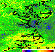
Figure 3.% cloud cover for SW wind regime, May-July, 1998-2000, 1645 UTC
Another feature of interest for the Wakefield region is "Bay Plumes/Streamers", an enhanced convective line over the Chesapeake Bay usually seen during the cool season. These plumes can sometimes enhance other convection in the area and trigger severe weather such as waterspouts. Since northerly winds are one of the conditions for setting up a bay plume, the N wind regime for the August-October was examined (Figure 4). While the N regime has only an average of 36 cases per hour, a hint of the bay plume can be seen during the early morning hours in the lower Chesapeake Bay, southwest the lower Eastern Shore tip.
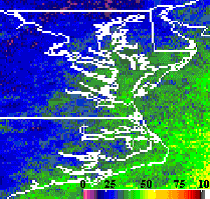
Figure 4. Percent cloud cover for North wind regime, Aug-Oct, 1998-2000, 1245
UTC
SECTION 2: SUMMARY OF UNIVERSITY/ NWS/AFWA/NAVY EXCHANGES
2.1 Most communications by the two groups have been done via email. A poster
presentation and accompanying manuscript was written with input by both groups.
SECTION 3: PRESENTATIONS AND PUBLICATIONS
3.1 The results will be presented at a poster session for the 11th Conference
on Satellite Meteorology and Oceanography in Madison, WI in October.
Combs, C.L., N. A. Stuart, M. DeMaria, and T. H. Vonder Haar, 2001: Wind regime GOES cloud cover composites for the Wakefield, VA County Warning Area. Preprints, 11th Conf. on Satellite Meteorology and Oceanography, Madison, WI, Amer. Meteor. Soc., in press.
SECTION 4: SUMMARY OF BENEFITS AND PROBLEMS ENCOUNTERED
4.1 Benefits to the University and Problems Encountered
There were no major problems with this study. The NWS personnel were very helpful and great to work with. It has been invaluable to be able to collaborate with a field office. By opening up discussions of the preliminary product, we were given a better idea of their forecasting concerns and interests. This knowledge allowed us to produce a more useful product for field operations, instead of trying to guess what would be of interest. They have also provided insight into the area and its weather from a local perspective. In addition, we were able to hire a student hourly from a local High School, who has gained computer experience and some exposure to satellite data processing.
The only drawback is that it would have been nice to have had one session to discuss the final products with both groups in a room, instead of just segmented discussions via email.
4.2 Benefits to the NWS and problems encountered
At this stage in the collaboration, the web site has helped us determine some
persistent cloud features, that are implied within the percent cloud cover displays,
for wind regimes from south through west and north. For example, there is higher
percentage of cloud cover in areas of localized convergence such as peninsulas
around the Chesapeake Bay. There is also some support of a Chesapeake Bay feature,
depicted as a relative maximum in percent cloud cover, for the north wind direction.
There are not enough cases for effective evaluation of northeast through southeast
wind regimes. However, the 10 or less cases suggest these wind regimes feature
characteristically high percentages of cloud cover, which would have a high
impact on aviation forecasting. Adding cases from this year would increase the
number of cases for these wind regimes.
More careful analysis of the data on the web site is needed before specific forecast applications for convective development or aviation forecasting can be developed. Specific forecast applications must be developed before more staff become involved in the project, specifically for evaluation of forecast applications.