The overall objective of this study is to find relationships between the GPS
Integrated Precipitable Water (IPW) data at Blacksburg VA (BLKW) and KFCX WSR-88D
radar data in order to better predict significant convective rain events capable
of producing flash flooding. Specific objectives include the following:
Direct comparisons between the GPS
IPW and radiosonde-measured PW indicated a very close agreement, and while comparison
with GOES-PW showed the GOES data to have a small wet-bias, overall trends were
very similar. While GOES PW data is not available during periods of cloud cover,
and the grid point closest to the Blacksburg lat/lon can change every hour,
GPS IPW is available every 30 minutes and in near-realtime (30 minute latency)
regardless of cloud cover. Comparisons with radar-observed trends showed close
correlation, but with peaks in GPS IPW offering little if any lead time. This
corroborated subjective evaluation by the forecasters who observed little difference
in peaks in IPW trends from peaks in convective activity. Therefore, the focus
shifted to correlating decipherable trends in the IPW time series with automated
gage measurements of significant rainfall rates in an attempt to identify signals
that would provide some lead time. It was also found that wintertime IPW almost
replicates the same pattern at different nearby receiver locations as synoptic
scale storm systems dominate the signals as they propagate across portions of
the network. In contrast, smaller scale fluctuations in the summertime IPW trend
showed little correlation between the two sites, suggesting these subtle variations
are likely due to mesoscale or even storm scale phenomena, and are likely important
to the behavior of convection.
A more detailed trend analysis and
comparison with climatological thresholds (the climatology was based on historical
radiosonde data) revealed the potential to achieve 1-2 hours or more of lead
time before heavy rain was observed at gages within 100 km. This lead time was
based on IPW values exceeding and remaining above a particular threshold for
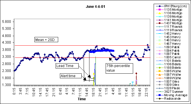
a certain period of time. Figure 1 illustrates one example where the IPW crosses
the 75th percentile based on that month’s climatology, and remains above
for at least four hours. A running average was also calculated to smooth out
extremes (or in case only data point fell below the threshold). This time constraint
results in the “lead time” being less than the “alert time”
(when the threshold is first met) but minimizes the false alarm rate.
The results are promising, and may
warrant experimentation of an automated algorithm and more thorough analysis
of verification rather than just for a select list of events. Certainly the
high temporal resolution data shows promise as an important tool for increasing
operational forecasters situational awareness of impending heavy convective
rain events.
SECTION 2: SUMMARY OF UNIVERSITY/
NWS/AFWA/NAVY EXCHANGES
There has been a strong interaction
between the NWS officials and Virginia Tech faculty and students. The NWS officers
are frequent speakers for seminars organized by the various departments at Virginia
Tech. Students from Virginia Tech have held part-time positions at the NWS office.
There have been numerous tours to the NWS facilities by student groups and classes.
There has been a good amount of data transfer from the NWS to the various departments.
The NWS personnel are considered an excellent resource for their technical knowledge
and are constantly engaged in technical discussions related to both problem
formulation and its solution.
SECTION 3: PRESENTATIONS AND PUBLICATIONS
Loganathan, G.V., Keighton, S.,
Gillen, M., Eisenberger, T., Gorugantula, S., Kibler, D.F., and Gutman, S.,
, “GPS Enhanced Radar Precipitation Estimates for Real-time Applications”,
World Water and Environmental Resources Congress: Bridging the Gap, ASCE, Edited
by D. Phelps and G. Sehlke, Orlando, FL, May 20-24, 2001.
Keighton, S., Gillen, M., Loganathan,
G.V., Gorugantula, S., and Eisenberger, T., “P5.14 The use of GPS integrated
precipitable water measurements to supplement WSR-88D parameters in determining
the potential for flash flood producing rainfall”, Ninth Conference on
Mesoscale Processes, AMS, Ft. Lauderdale, FL, July 30 – August 2, 2001.
Loganathan, G.V., Eisenberger, T.,
Gorugantula, S., Kibler, D.F., Keighton, S., and Gillen, M., “Assessing
Flash Flood Potential with the Aid of GPS Integrated Water Vapor Estimates”,
Virginia Water Research Symposium 2001, Charlottesville, Virginia, November
14-16, 2001.
Loganathan, G.V., Eisenberger, T.,
Gorugantula, S., Kibler, D.F., Keighton, S., and Gillen, M., “Use of GPS
Integrated Water Vapor Estimates in Short-term Prediction of Rainfall”,
Proceedings of the ASCE Environmental and Water Resources Institute (EWRI) Annual
Conference, May 19-22, 2002, Roanoke, Virginia.
S. Gorugantula, " The Use of
GPS Integrated Water Vapor Estimates in Short-term Rainfall Prediction",
MS Thesis in Progress, Department of Civil and Environmental Engineering, Virginia
Tech, Blacksburg, VA, 2002.
An informal presentation on data
availability and preliminary findings was presented by S. Keighton at the COMET
Symposium on Heavy Precipitation and Flash Flooding, October 2001.
The S. Gorugantula M.S. thesis was
summarized and presented to forecasters at WFO Blacksburg during a seasonal
Heavy Precipitation and Flash Flooding Workshop, May 9, 2002.
SECTION 4: SUMMARY OF BENEFITS AND
PROBLEMS ENCOUNTERED
4.1 (Academic Partner) The best
single most benefit is the access to the sophisticated instrumentation and the
countless hours of fruitful discussion with the NWS officers in sharing and
implementing the research ideas. The Virginia Tech researchers will write proposals
using the knowledge that they have gained from this research with the NWS officers.
4.2 (Forecaster Partner) Most significantly,
forecasters gained an understanding of a new observing system and began incorporating
the data into their mesoscale forecast process. The results of the research
were presented to operational staff at an on-station workshop. While no specific
evidence has been gathered to prove the research has helped improve forecasts
(there have been very limited events since the research has been completed),
forecasters have been accessing the data plots available from the internet,
and comparing the trends with the monthly thresholds, and likely increasing
their situational awareness which would typically lead to faster warning decisions.
More efficient local displays need to be developed to facilitate operational
use of the research results, and this will be possible as soon as local data
can be made available through AWIPS. The added experience of producing a paper
and making a presentation at an AMS Conference was another important benefit,
as was continuing to foster our collaborative relationship with the faculty
and students at VA Tech.
One problem encountered had to do
with efficiently analyzing all the radar data for the series of events we had
identified. The students did not have enough time to do a thorough job with
this, which was one of the reasons the focus was placed on comparisons with
rain gage data; it was easy to place archived digital data from the automated
gages into spreadsheets for analysis. As a result, the objectives related to
comparisons with radar data were not completely met, as only limited data sets
were used. We also discovered that PW date from RUC hourly forecasts was not
an output field and so this comparison could not be used. We could have used
3-hr forecasts from archived Eta model grids but we ran out of time to collect
and analyze these data. We were most interested in the accuracy of very short
range hourly forecasts from the RUC.