SECTION 1: PROJECT OBJECTIVES AND ACCOMPLISHMENTS
The goal of this study was to: 1) incorporate the Intracoastal Waterway into an existing finite element model for the east coast of South Carolina; 2) examine the effects of tidal flow through the Winyah Bay and the Intracoastal Waterway; and 3) develop a downstream boundary condition for an application of the Flood Wave (FLDWAV) model. All three milestones were completed as a result of the joint cooperative effort of the University of Central Florida and the Southeast River Forecast Center (SERFC).
The objective of this project was to modify an existing two-dimensional tidal model for the coastal region surrounding Conway, South Carolina (SC) to include the Intracoastal Waterway. The tidal model was used to examine the effects of tidal flow through the Winyah Bay and the Intracoastal Waterway and develop a downstream boundary condition for the FLDWAV model that is used by the National Weather Service River Forecast System (NWSRFS). Results from this project are expected to enhance forecasting by the Southeast River Forecast Center.
The Civil and Environmental Engineering Department at the University of Central Florida accomplished the following two major tasks during this study. Details on all aspects of the research can be found in the publications that are listed in Section 3 of this report.
1) A two-dimensional, finite element domain was modified to include the Intracoastal Waterway for the coastal region surrounding Conway, SC.
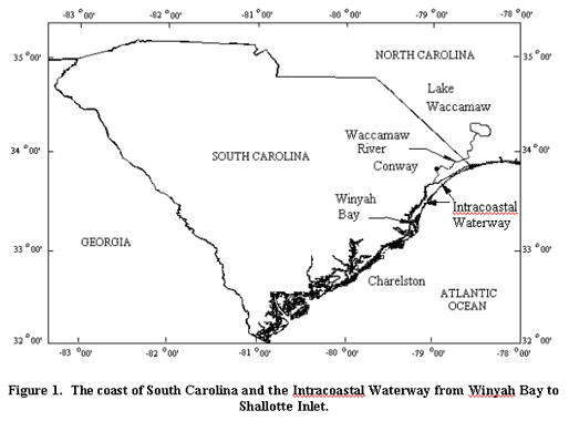
The project area is located in the northern region of the South Atlantic Bight along the southeast coast of the United States. The Waccamaw River drains the coastal areas of southern North Carolina and northern South Carolina. The river leaves Lake Waccamaw in North Carolina and flows southward through Conway, South Carolina. From there, the river flows southward to the confluence with the Great Pee Dee and Black Rivers, through Winyah Bay, and into the Atlantic Ocean as shown in Figure 1 (end of report).
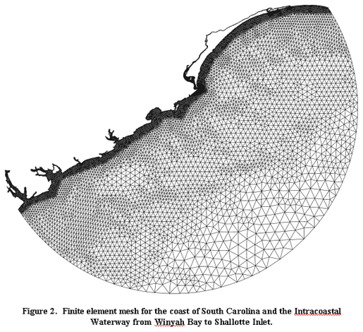
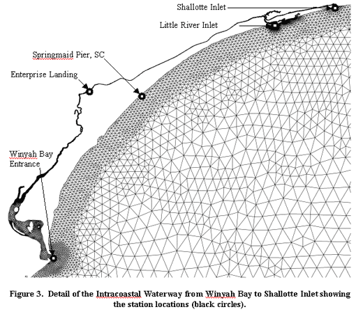
An existing unstructured mesh (produced under UCAR Contract No. UCAR S98-98908) was modified to include the Intracoastal Waterway for the coastal region surrounding Conway, SC. The final unstructured grid (Figure 2) uses 24,911 nodes to define discrete locations and depths. 14,898 nodes were added to the existing mesh in order to adequately resolve the Intracoastal Waterway. Figure 3 presents a detail of the Intracoastal Waterway and shows station locations for model output.
2) Simulations were performed to examine the effects of tidal flow through the Winyah Bay and the Intracoastal Waterway and to verify the model based on historical data.
Nonlinear, hydrodynamic calculations
were performed with ADCIRC-2DDI, a two-dimensional depth integrated circulation
code. The simulation employed a constant bottom friction coefficient of 0.003,
a generalized wave continuity equation weighting parameter of 0.009, which controls
the contribution from primitive continuity, and an eddy viscosity of 0.0. A
no-flow boundary condition was enforced at all land boundaries and open ocean
boundaries were forced with the ![]() and STEADY tidal constituents. 90 days of real time were simulated with
the unstructured mesh (Figure 2). A time step of three (3) seconds was used
to meet Courant condition requirements and ensure dynamic steady-state results.
In addition, a hyperbolic ramping function was imposed during the first 15 days.
and STEADY tidal constituents. 90 days of real time were simulated with
the unstructured mesh (Figure 2). A time step of three (3) seconds was used
to meet Courant condition requirements and ensure dynamic steady-state results.
In addition, a hyperbolic ramping function was imposed during the first 15 days.
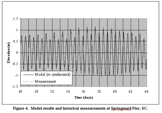
Figure 4 shows historical and modeled tide gage data at Springmaid Pier, SC (see Figure 1 for location) for a period of 16 days. Good model agreement with the historical record is seen upon examination of Figure 4.
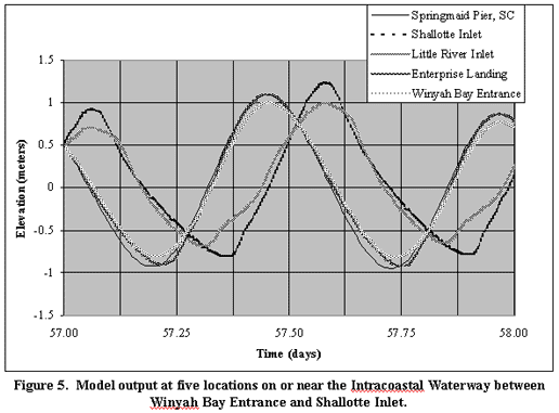
Figure 5 presents a one-day sample of the tide-stage hydrographs for the Intracoastal Waterway, including the Springmaid Pier, SC location. Figure 5 displays the variance in the tidal signal through the Intracoastal Waterway. Figure 5 also shows that the tide gage at Springmaid Pier, SC mirrors the tidal signal at Enterprise Landing, however, it should be noted that future efforts will include the simulation of hurricane storm surge and use model output for the boundary forcings. Therefore, the location of a downstream boundary for our future NWSRFS river forecasting effort should be at Enterprise Landing. Failure to do so will result in errors that could significantly effect river stage forecast accuracy.
SECTION 2: SUMMARY OF UNIVERSITY/ NWS EXCHANGES
In late January 2001, John Feldt, Hydrologist-in-Charge, SERFC, NWS, visited the University of Central Florida, viewed progress up to that time, and coordinated with Dr. Hagen regarding future progress on this project. In February 2001, Reggina Garza of SERFC attended the National Weather Service's Coastal Storms Workshop in Destin, Florida.
Two students at UCF (Mr. Dustin Dipersia and Mr. Ryan Murray) have been educated on the development of a finite element model and on the use of the ADCIRC tidal model. The students also visited the SERFC on August 13, 2001 with Dr. Scott C. Hagen and discussed the work-to-date, future plans and began learning about the operational tasks associated with the SERFC's mission. Finally, Dr. Scott C. Hagen attended the National Weather Service's Coastal Storms Workshop, which was held in Destin, Florida on February 13 and 14, 2001.
FLDWAV, the current generation of NWS one-dimensional dynamic river modeling software, was implemented by Reggina Garza in stand-alone mode for the St. Johns River in Florida. This project, though it applied to a Florida river, has created expertise in the SERFC that will benefit the implementation effort of FLDWAV in coastal South Carolina.
Dr. Hagen and the SERFC wrote, submitted, and are presently funded to perform an NWS Cooperative Project (UCAR S01-32794) entitled "A Demonstration of Real-Time Tide and Hurricane Storm Surge Predictions for the National Weather Service River Forecast System." This is an extension of the present Outreach Program collaboration (UCAR S01-24233) and previous efforts (UCAR S98-98908).
SECTION 3: PRESENTATIONS AND PUBLICATIONS
Presentations:
Hagen, S.C., A Series of Lectures on Unstructured Mesh Generation and Tide and Storm Surge Modeling, Chuo University Graduate School of Science and Engineering, Tokyo, Japan, May 28-June 17, 2001.
Hagen, S.C., "Hurricane Surge and Tidal Computations Using a Finite Element Model," ASCE Water Resources Annual Conference, Orlando, FL, April 6, 2001.
Hagen, S.C., D. Dipersia, R. Murray, and D.M. Parrish, "Tide Predictions for the Waccamaw River Including the Intracoastal Waterway," 7th International Conference on Estuarine and Coastal Modeling, St. Pete Beach, FL, November 5-7, 2001.
Publications:
Hagen, S.C., O. Horstman and R.J. Bennett, "An Unstructured Mesh Generation Algorithm for Shallow Water Modeling," The International Journal of Computational Fluid Dynamics, In Press.
Hagen, S.C., D. Dipersia, R. Murray,
and D.M. Parrish, "Tide Predictions for the Waccamaw River Including the
Intracoastal Waterway," Proceedings of the 7th International Conference
on Estuarine and Coastal Modeling, St. Pete Beach, FL, In Preparation.
SECTION 4: SUMMARY OF BENEFITS AND PROBLEMS ENCOUNTERED
4.1 Benefits to the University
Dr. Hagen has presented aspects of operational forecasting to students in his Hydrology class (CWR 4101) at the University of Central Florida. Two UCF undergraduate students, Dustin Dipersia and Ryan Murray, are actively involved in this COMET project. As noted above, the students also visited the SERFC on August 13, 2001 with Dr. Scott C. Hagen and discussed the work-to-date, future plans and began learning about the operational tasks associated with the SERFC's mission. Both Dustin and Ryan are enrolled in the UCF Civil and Environmental Engineering graduate program for the Fall Semester of 2001 and will use their experience to develop their Masters Theses. Finally, this research will also benefit other undergraduate and graduate students at UCF.
No problems have been encountered.
4.2 Benefits to the NWS Office
The waves that originate from tidal fluctuations in the Waccamaw River are not accounted for in the present NWSRFS model for this region. However, the NWSRFS does have the capability of incorporating such effects by employing FLDWAV. The tidal model developed as part of this COMET project will improve the river forecasting at the Waccamaw River because of the accurate boundary conditions that were produced and are needed to run FLDWAV.
Figures: