1. ABSTRACT
This report describes application of satellite image processing procedures for classifying land uses and fire burn areas, and categorizing their flood runoff characteristics. Primary data sources for this effort included satellite imagery and aerial photos. Land use classifications were conducted on two adjacent LANDSAT-7 Level-1 images shot at the same date (14 Sep 2000). The 2000 classifications were compared to classified 1990 imagery downloaded from USGS National Land Cover Data (NLCD) project using change detection techniques on the rectified and registered images. Changes in land use and associated impervious surfaces were tabulated for the region and subpart counties and selected watersheds. For example, in the rapidly developing Arapahoe County, impervious surfaces increased about 4 percent (3% to 7%) during the 10-year period. Some watersheds showed considerably higher increases on the order of 30 percent.
Various demonstrations and data exchanges with the WFO Boulder staff were accomplished during the conduct of the study. A training seminar will be conducted in April for the WFO Boulder forecasters to illustrate procedures used and results obtained. The land use - land cover imagery developed will be provided to the WFO Boulder for their use to support hydrologic operations.
2. PROJECT OBJECTIVES AND ACCOMPLISHMENTS
2.1 Objectives of Research Project
Objectives of the research included the following:
o Develop satellite image processing, field data collection and related data
analysis procedures for identifying and characterizing flood runoff potential
for fire burn and urban lands.
o Provide training through demonstrations to WFO Boulder staff in using satellite
image processing software to characterize flood runoff potential.
2.2 Introduction
Rapid urbanization of the Colorado Front Range region is of concern from a flood runoff point of view due to increases in impervious surfaces of roadways, parking lots and rooftops. Also, there have been several forest fires in the Rocky Mountain foothills which have altered runoff characteristics. For example, the Buffalo Creek fire caused sealing of the soils so that almost none of the rainfall on 12 July 1996 infiltrated and severe flash flood resulted. Impervious and severely burned surfaces have minimal water holding capacity and rainfall is quickly translated into flood runoff that threatens local and downstream areas. Although urbanization does not happen as quickly as a forest fire, the rate of development along Colorado's Front Range requires frequent updating of hydrologic databases.
The purpose of this project was to develop high resolution mappings of WFO-Boulder fire burn and urbanized lands. We worked closely with WFO-Boulder forecasters and management to identify flash flood operations information needs and operations procedures that would make use of the imagery developed.
2.3 Description of Research/Development Accomplishments
2.3.1 Task 1: Review literature for satellite remote sensing of land use.
Description: CU Denver graduate students reviewed recent literature on remote sensing and image classification procedures for land surface hydrologic characteristics. We reviewed activities of the NWS NOHRSC, US Forest Service and other agencies to ascertain whether their work related to our research topic.
2.3.2 Task 2: Obtain satellite imagery for Colorado fire burn and urban areas.
Description: The graduate students identified available digital imagery sources
per the design and proceed ed to order the imagery. We also collected ancillary
data from other agencies on the forest fire burn and urban areas (e.g., flood
runoff data, infiltration analyses). These activities are described in detail
in the companion final report.
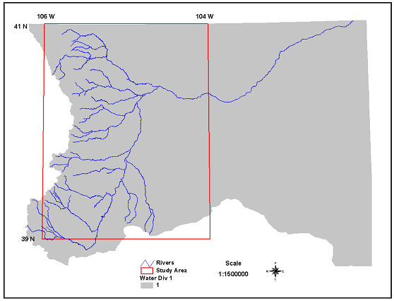
The WFO Denver forecast region was taken to be bounded by the window -104° W to -106° W and from 39° N to 41° N (See Figure ). This area extends for the Palmer Divide near Colorado Springs north to Cheyenne, Wyo., and from east of Limon west to the Continental Divide.
2.2.3 Task 3: Image processing and ground truth collections.
Description: Graduate students applied alternate image processing procedures to the satellite imagery for the fire burn and urban areas. They identified "training" sites for field data collection where ground truth data can be collected by the student team. These data included high resolution aerial photos for the urban areas that supported identification of lot-size impervious surfaces and area computations. These activities are describe din detail in the companion final report.
2.2.4 Task 4: Analysis of Fire Burn and Urban Area Land Surface Runoff Characteristics.
Description: Analyses of the image processing, ground truth and ancillary data collections were brought together to obtain the final research products. These activities included hydrologic modeling of small watersheds to establish the hydrologic response relationships we are seeking.
2.2.5 Task 5: Prepare Final Report and Conduct WFO Training
Description: A Final Report was prepared describing the procedures and results obtained. A training seminar will be conducted with interested WFO Boulder forecasters using available image processing software to illustrate how the procedures might be conducted by the forecasters on a continuing basis.
3. SUMMARY OF UNIVERSITY/NWS EXCHANGES
3.1 Collection of other agency data.
At the outset of the project, we met with the WFO Boulder Service Hydrologist and Fire Weather specialist to obtain information they had obtained from other agencies on the fire burn areas and related studies.
3.2 Interim reviews and demonstrations.
At the end of month 8, a progress report and demo was submitted for review by the WFO Boulder. At the end of month 10, draft a progress report and demo were presented for review by the WFO Boulder.
3.3 WFO Training Seminars
Submitted report to WFO for review and feedback. Conduct of training seminars planned for April.
3.4 Land Use / Land Cover Database Handoff
The land use - land cover imagery developed will be provided to the WFO Boulder for their use to support hydrologic operations.
4. PRESENTATIONS AND PUBLICATIONS
4.1 Report On Mapping Flood Runoff Potential For Forest Fire Burn And Urbanized Lands.
The full report on the image processing and land use database development procedures and coverage metadata is appended to this report.
4.2 CU Denver Graduate Student Research Presentations
The WFO Boulder Service Hydrologist was able to attend the graduate student
report presentations at CU Denver in November. Graduate students presented their
GIS research and project work at the workshop; two of the presentations were
based on the subject land use database development project, including:
a) Wang, Liang-Chen on Mapping Flood Runoff Potential For Forest Fire Burn And
Urbanized Lands.
b) Tang, Sau-Veng on Dynamic Hydrologic Atlas
Also, another graduate student - Jeffrey Cheng - analyzed high resolution aerial photography for impervious surface area of new land development projects in SE Denver metro region.
4.3 Other Seminars
Research results obtained from the project have been included in several seminar presentations, including:
4.4 Conference Paper Presentation
A paper - Mapping Changes In Flood Runoff Potential Along Colorado's Front
Range (L. E. Johnson, L.C. Wang and T. Huse)- has been accepted for presentation
at the 15th William T. Pecora Memorial Remote Sensing Symposium to be held jointly
with the Land Satellite Information IV Conference and the ISPRS Commission I
Mid-term Symposium Denver, Colorado, November 8 to 15, 2002.
5. SUMMARY OF BENEFITS AND PROBLEMS ENCOUNTERED
5.1 University's Perspective
This project provided UCD GIS graduate students with first-hand exposure to the development of spatial databases for a life-critical public safety application. The students benefited from the field visit to review the WFO Advanced forecasting system. They also benefited in discussing the types of data desired by the forecasters on flood impact features. The interaction of students and forecasters was considered very valuable and relevant, and further interactions off this sort were desired by the students.
5.2 NWS Perspective
The UCD seminars provided an excellent introduction to forecasters at Denver.
The next step would be to get these maps and other databases developed by UCD
graduate students incorporated into AWIPS as soon as possible. We are exploring
the possibility of using the land classification imagery as a backdrop on the
AWIPS workstation so that radar-rainfall imagery can be displayed as an overlay.
That way we could see if intense rainfall events occur over fire burn and/or
impervious urban areas. Meanwhile some advanced GIS training may provide some
benefits to forecasters at Denver as well.