(From Final Report abstract)
Between June 25 and June 27 1995, severe flash flooding ravaged the mountainous regions of Virginia, resulting in three fatalities and millions of dollars in damage. The flooding culminated on June 27th as a convective system (the Piedmont Storm) developed over Madison County, Virginia, and drifted southward dropping 100mm to 300mm rain over a narrow swath of the Virginia Piedmont resulting in moderate flooding. Soon after this complex exited Madison County, another convective system (the Madison Storm) developed over Madison County. This system remained quasi-stationary along the eastern slopes of the Blue Ridge for nearly eight hours, unleashing locally more than 600mm rain and resulting in catastrophic flooding.
An analysis of this event indicates that the synoptic conditions responsible for producing and maintaining the Madison Storm were very similar to the Big Thompson and Fort Collins floods along the front range of the Rocky Mountains, and the Rapid City flood along the east slopes of the Black Hills of South Dakota. In all four cases a fast moving ribbon of high theta-e air behind a weak surface front provided a copious moisture supply, while an approaching shortwave aloft insured favorable upper level dynamics. Mountain ranges oriented perpendicular to the low level flow focused the convection over a small area, resulting in the development of quasi-stationary storm complexes. In the present case, the Piedmont storm also contributed to maintaining the delicate balance required to sustain the Madison Storm.
(From Concluding Remarks Section in Final Report)
The atmospheric conditions responsible for the Madison County flood bore a striking resemblance to other devastating
upslope floods in the U.S., particularly the Big Thompson, Fort Collins, and Rapid City floods. The Madison County
event demonstrates that this life threatening scenario is not restricted to the western United States, but can
occur along other mountain ranges as well. It is therefore important to recognize the meteorological ingredients
that are responsible for these events.
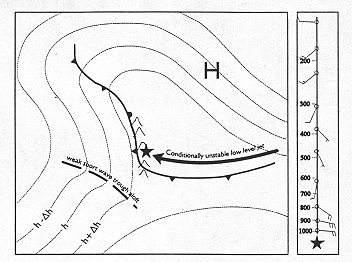
The Figure presents a schematic of the major features common to each of the flood events. In each case, the storms develop between the trough and ridge of an upper-level, large-scale, negatively tilted wave. The trough and ridge straddle a north-south mountain range and generate pronounced low-level easterly flow along the east slopes of the range. Mid-level steering currents are light and southerly overtop the affected region. A weak shortwave is rotating around the trough and approaching the threat region from the southwest.
A surface high centered north of the affected region pushes a cold front southward along the eastern slopes of the mountain range. The post-frontal pressure gradient is locally tighter than nearby pressure gradients and generates a low level ribbon of strong easterly winds oriented nearly perpendicular to the mountain range. The cool, moist, conditionally unstable post-frontal flow undercuts tropical-like air ahead of the front, resulting in a weak capping inversion which prevents the release of the instability until it is lifted orographically. Deep convection develops where the post-frontal easterly ribbon is lifted by the higher terrain. Individual cells drift northward in the weak southerly steering currents as the slow southward progress of the surface high and its associated post frontal low-level easterly flow focus the convection over the same general area for several hours. The approaching shortwave and upper level divergence maintain favorable deep tropospheric forcing throughout the storm's duration.
The moist, tropical-like air in place overtop the cool surface-based flow exhibits a high in-cloud freezing level. Radar cross sections show sloping updrafts and a low-echo centroid. Warm cloud processes dominate precipitation production. Moist mid to upper levels, deep warm cloud processes, and cloud bases near the ground severely limit cooling by melting andevaporation thereby minimizing the formation of cool moist downdrafts and propagation of the system away from the mountains.
These ingredients often do not result in the delicate
equilibrium necessary for a terrain induced quasi-stationary convective system. Nevertheless, they should be heeded
as strong warning signs that a life threatening flash flood is possible. Although this paper focused on a single
scenario in which to create this equilibrium, there are other ways it can be achieved. For example, west-slope
upslope events have been documented wherein the local terrain features induce deep convective overturning of moist
post-frontal Pacific air (Reynolds 1997, Vardiman and Heggli, 1981). As with the east-slope events documented here,
the conditions favorable for west-slope events also evolve very slowly and can generate flooding rains as they
remain quasistationary for several hours. Of course, as shown by Maddox et al. (1979) and Schwartz et al. (1990),
forecasters should be wary any time a moist, conditionally unstable low level jet is forced to rise over a stationary/slow-moving
front or boundary, especially if the low level jet is expected to intersect the boundary at the same location for
an extended period of time.