1. Project Objectives and Accomplishments
1.1. Introduction.
The objective of this research is to make a hydrometeorological assessment of the Timber Lake dam failure and the associated flash flood event of June 22, 1995. The focus of the assessment is to develop a methodology to recognize an impending dam break and thereby improve the warning time associated with a dam break event. The study also explores the meteorological setting that led to the catastrophic rain event. The study team is comprised of Professors G.V. Loganathan, and D.F. Kibler and the graduate student Mr. J.M. Warner from Virginia Tech and Messrs. M.E. Gillen, R.J. Kane (now with the Pittsburgh NWS forecast office), S. Keighton, and K. Kostura from the Blacksburg NWS forecast office. The Virginia Tech team of researchers has the responsibility of analyzing the dam break event with a view towards improving the warning lead time. The NWS researchers have the responsibility for analyzing the meteorological precursors that led to the catastrophic rain event.
Due to excessive rainfall, the Timber Lake Dam (located about 8 km southwest of the city of Lynchburg in southwestern Virginia) failed at 0221 UTC on June 23, 1995 causing two fatalities. The 24-hour rainfall of 22.1 cm (cooperative observer report within 1.6 km of the Dam) is greater than the hundred year rainfall of 19.8 cm. The only nearby official rain gage located 4.6 km east of the Dam at the Lynchburg airport reported 12.7 cm. However, the WSR 88-D radar estimated the rain amount to be around 28 cm at the Dam site which agrees well with the cooperative observer report. Therefore, there is real value in the radar data in comparison to a sparse network of rain gages.
This aspect assumes particular importance when critical structures such as dams are involved. Another aspect is that short term increment of rainfall is obtainable from radar scan to scan data. Unless automated recording rain gages are employed throughout the area, such a short term areal average is not possible from rain gages. The inflow hydrograph is a crucial input for dam break analysis which is accurately estimated with the aid of short term rainfall increments. Therefore, there is a twofold advantage in using radar rainfall data in terms of overcoming sparse network of rain gages and providing short term data. The report is organized as follows. The section on description of research is comprised of three subsections. The meteorological factors section describes the precursors that led to the excessive rainfall over the Timber Lake basin. The section on the dam break analysis describes the simulation procedure and the results. The section on forecast procedure presents the results of a correlation analysis between the vertically integrated liquid (VIL) and the rain rate. Section 2 on the summary of university/NWS exchanges highlights the contributions made by the NWS officials to the university community. Section 3 lists the presentations and publications that sprung out of this project. The report ends with section 4, pointing out the benefits directly attributable to this research effort.
1.2 Description of Research/Development Accomplishments.
1.2.1. The Meteorological Factors. At 0000 UTC 23 June 1995 a closed low at 50 kPA was over the North Carolina-Tennessee border. A weak surface trough also extended from eastern Ohio across Southwestern Virginia over the Timber Lake basin and then east to the Atlantic coast. A weak low pressure (101.2 kPa) was centered near Augusta, GA with a second surface trough extending from the low northeast into central NC. Surface dew points across VA and NC at 0000 UTC 23 June 1995 ranged from 19ºC to 22ºC (66ºF-72ºF) and the precipitable water was 4.14 cm (1.63 in.) based on the 0000 UTC Greensboro, NC (GSO) sounding.
The Nested Grid Model (NGM) analysis at 0000 UTC 23 June 1995 shows a convergence of Q-vectors indicating upward vertical motion. The area of Q-forcing extends from west-central Virginia southward across the Timber Lake area. The isotach analysis for 0000 UTC 23 June 1995 at the 20 kPa level reveals the presence of a jet streak of 36 m/sec over south-central Virginia. It is suggested that the ageostrophic transverse circulations associated with the jet streak induced upward vertical motion. The vertical cross section from the 00 hr NGM 0000 UTC 23 June 1995 from 36.5N, 90'W to 36.5ºN, 71ºW slicing through south-central Virginia shows that the greatest vertical velocity of 3.6(10-3) µb/sec and the maximum in the ageostrophic circulation are both located directly over the Timber Lake basin.
From microphysical point of view, the data on cloud height were considered. The warm cloud layer depths from the three closest soundings to the Timber Lake area at 0000 UTC 23 June were 3.0 km at Greensboro, NC (GSO), 3.1 km at Dulles, VA (IAD), and 4.3 km at Wallope Island, VA (WAL). The average of 3.7 km is obtained for the more representative GSO and WAL readings. This 3.7 km warm cloud layer depth is comparable to those of the Cheyenne, WY, Big Thompson, and the Rapid City flash flood events. The deep warm cloud layer would greatly favor the rain production efficiency by permitting greater residence time for the drops in terms of the collision-coalescence and drop break up processes. More elaborate discussions are given in (Kane et al. 1996). In the following, a mathematical simulation of the dam break process that took place as the result of the immense rainfall is presented.
1.2.2. Dam Break Analysis. The Timber Lake dam has a drainage area of about 13.5 km2. The dam is 183 m. long and is of 9 m. height. It is an earthen dam and a freeboard about 1.8 m. is usually maintained. Rain showers had been detected by the Doppler radar at around 1:00 p.m. local time (1800 UTC) with the intense rains occurring between 2100 UTC on June 22 and 0300 UTC on June 23. The only nearby regular data gathering rain gage located at the Lynchburg airport about 3 miles east of the dam reported about 12.7 cms of rain accumulation whereas the radar and some independent observers reported in excess of 28 cms for the 24 hour duration from 0700 EDT on June 22 to 0700 EDT on June 23. The Timber Lake dam failed because of over-topping by water on June 22, 1995 at about 10:20 p.m. Compared to the mean areal precipitation estimate from a sparse network of rain gages, the radar estimates are more accurate. The radar continually samples a volume of space with a height of about 914 m and 230 km radius. The rainfall values are reported over a 2 km x 2 km grid system. The rain accumulations are updated for each volume scan with a temporal resolution of about 10 to 14 min.
In this study the radar precipitation data are utilized. Short term increments of precipitation data, as opposed to the accumulated total, yield an accurate inflow hydrograph. Such an approach clearly illustrates the ability of the WSR-88D to track the precipitation continuously and is the type of data needed for dam break modeling. Also of value in this particular instance, is the smaller grid size used by the radar which suits well for the Timber Lake basin which has an area of only 5 sq miles as opposed to a large grid one normally encounters in a rain gage network. The following field data of dam breach of 55.5 m (182 ft.), the lake surface area of 34.4 hectares(85 acres), the dam height of 9m, the length of 183m, and the normal freeboard height of 1.8 m are used for the computer modeling.
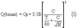
The dam break simulation was performed using the DAMBRK hydraulic model (Fread, 1991). The inflow hydrograph for the DAMBRK model was generated from the HEC1 (US Army Corps of Engineers, 1990) hydrologic model. Two computer programs Simplified Dam Break Flood Forecasting Model (SMPDBK) and its rigorous parent version NWSDAMBRK are available from the National Weather Service. These models are used to analyze the event. In the SMPDBK program the following falling head broadcrested weir equation (Fread, 1980) is used to compute Q(bmax), the maximum breach outflow
in which C = (23.4A)/B, A = reservoir surface area at the maximum pool elevation in acres, B = average final breach width in feet, T = time duration from the initiation to final breach width called failure time in minutes, H = difference between maximum water level and final breach bottom elevation in feet, Q0 = additional nonbreach outflow in cfs. For a breach width, B = 55.5 m. (182 ft.), the reservoir surface area at the maximum pool elevation, A = 34.4 hectares (85 acres), breach bottom measured from the water surface, H = 8.8 m. (29 ft), and Q0 = 0, the maximum breach outflow values are 1756 cumecs and 1289 cumecs (62,000 cfs and 45,500 cfs) for failure times of 15 min. and 30 min. respectively.
The DAMBRK model (Fread, 1991) consists of three main components, a breach geometry component which describes the breach growth with time; a breach outflow component which by employing a broad-crested weir approximation and storage accounting scheme generates the breach outflow hydrograph; a dynamic wave routing component for the downstream channel. The breach begins when the water level, hw, exceeds certain critical value, hi. The final breach width bf is related to an average breach width b(av) by
![]()
![]()
in which: Z = side slope parameter ZH: 1V of the trapezoidal breach, hd = height of the dam. The bottom elevation at anytime, s, is given by
![]()
in which hb = height measured to the final breach bottom, alpha = an exponent. The corresponding bottom width, b, is given by
![]()
Using b, h, Z, and hd values the trapezoidal breach geometry can be determined. The breach outflow,Qb is given as
![]()
in which beta = correction factor. The DAMBRK model uses hydrologic storage routing or dynamic wave model with Eq. (5) along with any nonbreach flow Q0 as the downstream boundary condition for the reservoir. Thus computed reservoir outflow is routed downstream by solving the Saint Venant equations (dynamic wave).
For 15 min. time of failure, the maximum breach outflow Q (bmax) is 1586 cumecs (56,000 cfs). The simulation provides an elapsed time of 9.6 hours from the start of the inflow hydrograph at 1700 UTC on June 22, 1995, putting the dam break at 0236 UTC which is within 15 minutes of the actual time of failure of the Dam. The peak flow of 56,000 cfs also agrees quite well with the field survey estimate by USGS of 50,000 cfs. Figures 1(a) and 1(b) show the water level at the Timber Lake in relation to the mean areal precipitation.
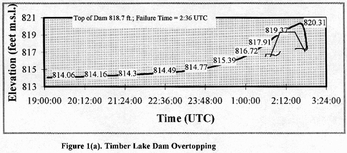
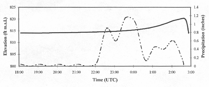
Figure l(b). Timber Lake Dam Overtopping Versus Rainfall
1.2.3. Forecast Procedure. The issuance of warnings for potential dam failures becomes complicated because the county warning area flash flood guidance values have to be linked with the site specific conditions of the dam. This task requires real time coupling of the prevailing conditions at the dam site and the current precipitation estimates from the radar and rain gages and the anticipated additional precipitation. The critical stage for a dam may be defined as that water level from which it will take exactly the critical lead time for the water to overtop the dam for a set of rainfall conditions. The critical lead time is the minimum time period needed for the emergency evacuation purposes. The gain in the critical lead time is directly attributable to the improvement in rainfall forecast lead time.
Vertical Integrated Liquid (VIL) and Rain Rate
By considering a vertical column of convective cloud, it can be shown that the rate of change of liquid water content
equals the difference between the moisture inflow and rain falling out. The liquid water content is designated
as VIL and is plotted against the radar estimate of rain rate, R = (z/a) (1/b) in which Z = radar reflectivity
in mm6/m3, a = 300 and b = 1.4, and R = rain rate in mm/hr. In Figure 2 the VIL values in kg/m2 and rain rate in
mm/hr are plotted against time. As can be seen from Figure 2 there is good correlation between the VIL and the
rain rate. However, the same analysis for stratiform type precipitation does not yield a high correlation. For
convective events with typical shorter lead time for forecasts, improvements can be made. Storm tracking also helps
to enhance the lead time by projecting VIL values to a downstream location. A predictive algorithm in the spirit
of Srivastava (1967) and French and Krajewski (1994) [also, see the references therein] is adopted for forecasting
VIL values. By considering the continuity equations for dry air, and the total water content (vapor, cloud water,
and rainwater), it is possible to show that the rate of change of VIL (vertically integrated liquid water content)
equals the difference between the moisture brought in and the rain falling out. Therefore, if the VIL and the water
vapor transport are known, the rainfall rate can be determined.
From the upper air data, in terms of the Convective Available Potential Energy (CAPE) and the mixing ratio, the water vapor transport can be estimated. Using a drop size distribution an expression for the volume of liquid water equivalent in a cloud column can be formulated. The radar equation in turn provides a relationship between the drop size distribution and the reflectivity. Therefore, from the reflectivity data the VIL is available. Because a state equation is available for the VIL, it lends itself for predictive techniques such as the Kalman filter. The algorithm can project a current VIL value from the upstream progressively advected VIL values following a storm. The correlation analysis for the VIL and the rain rate shows a lead-lag tendency between the VIL and the rain rate for convective systems. From the correlation analysis using the projected VIL value a rain rate value can be obtained which is the forecast. These ideas will be fully reported in Warner's (I 998) forthcoming MS Thesis.
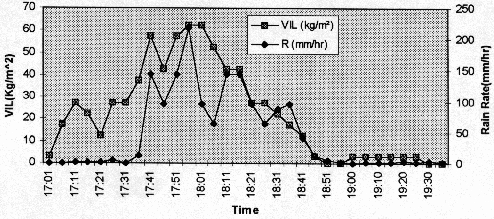
Figure 2. Vertically Integrated Liquid Vs Rain Rate
1.2.4 Summary: The following points emerge from this research.
Radar estimates are more accurate than the estimates from a sparse network of gages.
Radar provides rainfall estimates over short term increments and at a better spatial resolution. Both these aspects are ideally suited to hydrologic applications.
There is good correlation between the vertically integrated liquid and the rain rate which can be exploited for forecasting rainfall amounts.
There is a need for real time short term (digital) rainfall values for the dam break type hydrologic applications. The graphical output from the principal user processor should be made available in digital format for immediate use in real time applications.
There should be a communication linkage for reporting existing reservoir conditions to the NWS offices for updating initial reservoir conditions at the NWS offices. The involved local, state agencies, and owners should provide the geometry data on dams to the NWS offices.
1.2.5. Bibliography
Ely, P.B. and Peters, J.C., 1985: "Flood Runoff Forecasting with HEC-IF," Water Resources Bulletin, 1985.
Fread, D. L. (1980). "Capabilities of NWS model to forecast flash floods caused by dam failures," Preprint Volume, Second Conference on Flash Floods, March 18-20, American Meteorological Society, Boston, MA, pp. 171-178.
Fread, D.L., 199 1: "The NWS DAMBRK Model: Theoretical Background/ User Documentation," HRL-256, Hydrologic Research Laboratory, National Weather Service, Silver Spring, Maryland, 1988; Revised version 1991.
Fread, D.L., Lewis, J.M., and Wiele, S.M., 1991: "The NWS Simplified Dam-Break Flood Forecasting Model (SMPDBK)," Hydrologic Research Laboratory, National Weather Service, Silver Spring, Maryland.
French, M.N., and Krajewski, W.F., "A model for real-time quantitative rainfall forecasting using remote sensing", Water Resources Research, Vol. 30, No. 4, April 1994, pp. 1075-1083. Shedd, R., 1988: "Mosaic of WSR-88D Precipitation" Computer program, National Weather Service.
Srivastava, R.C., "A study of the effect of precipitation on cumulus dynamics", Journal of the Atmospheric Sciences, Vol.24, January 1967, pp.36-45.
U.S. Army Corps of Engineers, 1990:"HEC-1 Flood Hydrograph Package", Hydrologic Engineering Center, Davis, CA.
2. SUMMARY OF UNIVERSITY/NWS EXCHANGES.
There has been a strong interaction between the NWS officials and Virginia Tech faculty and students. Mr. M. Emlaw, Warning Coordination Meteorologist, Mr. M. Gillen, Service Hydrologist, Mr. R.J. Kane Science and Operations Officer (currently with the NWS Pittsburgh office), Mr. S. Keighton, Science and Operations Officer, and Mr. John Wright, the Meteorologist In Charge, are all frequent speakers for seminars organized by the various departments. Students from the various departments have taken up part-time positions at the NWS office. There have been numerous tours to the NWS facilities by the various student groups and classes. There has been a good amount of data transfer from the NWS to the various departments. There are plans to offer a new course called "Hydrologic Forecasting" which will make extensive use of the instrumentation and focus on algorithms suited to real time forecasting such as Kalman Filtering and Optimization techniques for storm tracking. The NWS personnel will serve as guest lecturers. The NWS personnel are considered a great resource for their technical knowledge and are constantly engaged in technical discussions related to both problem formulation and its solution.
3. PRESENTATIONS AND PUBLICATIONS.
Loganathan, G.V., Warner, J.M., Kibler, D.F., Kane, R.J., Gillen, M., and Kostura, K."Using NEXRAD Weather
Radar to Re-construct Timber Lake Dam Failure", Tenth Annual Virginia Water Conference '97, Fredericksburg,
VA, March 9-11, 1997.
Loganathan,.G.V., Warner, J., Kibler, D.F., Kane, R.J., Gillen, M., Kostura, K., "Flash Flood Forecasting,
Aesthetics in the Constructed Environment", 24h Annual Conference of the Water Resources Planning and Management
Division, ASCE, Houston, Texas, April 7-10, 1997.
From a regional competition the following presentation was selected for the American Water Works Association Meeting.
Warner, J. and Loganathan, G. V., "Flash Flood Forecasting with Doppler Radar for the Roanoke River",
Sixty Second Annual Virginia Section AWWA Meeting, Roanoke, VA, October 17-20, 1995(carries a cash award of $100).
Mr. J.M. Warner was selected to attend the seminar on "Dam Breach Analysis and Maximum Precipitation",
February 21-22, 1996, Inter Agency Committee on Dam Safety (ICODS), hosted by the Federal Emergency Management
Agency at the National Emergency Training Center, Emmitsburg, Maryland. (carries a stipend of $800).
Kane, R.J., Gillen, M., Kostura, K., Loganathan, G.V., Kibler, D.F., and Warner, J., "Hydrometeorological
Analysis of the Timber Lake Flash Flood and Dam Failure", 15th Conference on Weather Analysis and Forecasting,
Norfolk, Virginia, August 19-23, Paper No. 15 WAF FA 9.4, 1996.
6. J.M. Warner, "Flash Flood Forecasting", MS Thesis in Progress, Department of Civil Engineering, Virginia
Tech, Blacksburg, VA, 1998.
4. SUMMARY OF BENEFITS AND PROBLEMS ENCOUNTERED
4.1 University's perspective
Based upon this research, the Virginia Tech team and the NWS personnel wrote a stage 1 proposal to NASA "Improving
flash flood forecast lead time in potential dam failure". The writers have been encouraged to submit a fuller
version of the proposal for stage 2 consideration. More importantly, for the Virginia Tech faculty the NWS' personnel
and instrumentation are invaluable in formulating research focusing on hydrometeorology which would be otherwise
impossible.
4.2 NWS perspective
This project afforded our office its first opportunity to participate in a formal NWS-VT research endeavor. Initially,
the research team had one reservation concerning the project; namely that we might find it difficult to devote
the necessary time and resources the project would require with concurrent aggressive office spin-up activities.
It was agreed among the proposed research staff that the potential benefits the project would more than offset
the extra workload generated by our participation. Additionally, our participation would allow us access to expertise
and technological resources available through the university and the Civil Engineering Hydrology department.
The overall project consisted of three basic objectives we wished to accomplish:
The identification of the subtle meteorological features which interacted to produce the catastrophic rainfall amounts leading to the failure of Timber Lake Dam.
To investigate the applicability of Weather Surveillance Radar - 1988 Doppler (WSR88D) derived rainfall estimates for use as rainfall input into a real time hydrologic model.
To develop a methodology for alerting a local NWS office that a potential dam overtopping condition was evolving (with enough lead-time to adequately warn the public).
The first objective was accomplished with little difficulty. The NWS PC-Gridds datasets available for model forecast output, as well as archived observed surface and upper air data during the period investigated were adequate for meeting this particular objective. The second objective, applying WSR-88D precipitation estimates was less successful. The first hurdle to overcome was the fact that digitized output (which seemed to be the logical choice for input into a real-time hydrologic model) was available only on an hourly basis, and technical documentation on the product itself was lacking to say the least. Additional technical difficulties which precluded use of the digitized product:
No direct method was available to transfer a selected product from the Radar Product Generator (RPG) directly to an external computer platform. (The Service Hydrologist wrote a PC program which requested the HDP product from AFOS and stored it for use by a second program which then displayed a graphical representation of the data.) We obtained the source code for this second program and Dr. Loganathan was able to modify it to display the numerical array elements contained in the Hourly Digitized Precipitation product (HDP), but without adequate additional technical documentation the HDP product proved unusable.
Lack of resources in terms of computer program development time and the awkward way in which these data were handled led to the abandonment of this approach. A graphical One Hour Precipitation (OHP) estimate is produced each volume scan, enabling a theoretical time step of five minute rainfall estimates for use as model input. However, the same limitations applied as to our ability to transfer that output to an external system. Additionally, we were unable to obtain any documentation as to the technical content and format of the product as it is produced within the RPG.
To meet our second objective, input values for the hydrologic model were calculated by manual manipulation of Level III archived OHP products. This method proved successful for study purposes, but would not be applicable for operational use. The third objective was successfully met. We developed the concept and definition of "Critical Lead Time" (Def.- The minimum time required for effective emergency management response to a developing situation). We conceptualized an automated reservoir monitoring and alerting system which incorporated "Critical Lead Time" factors in alerting a local office to a potential "overtopping" condition. The conceptualized system consisted of a hydrologic model running in near real time, using WSR-88D rainfall estimates as precipitation input and allowed interactive mode operations for inputting forecast precipitation as well. The possibility of developing this conceptual model to at least a working prototype was discussed by the team members as a future cooperative research effort.
From our office's perspective, this project was
a success. Our office was forced to scale back its direct participation after this first phase of the project was
completed due to the loss of our Science and Operations Officer. The university research team members further expanded
on the original investigation and completed several related papers based on their additional research. Our office
contributed in these endeavors only to the extent of providing access to radar products and technical information.
Our office is looking forward to participating in additional joint research projects, and are enthusiastic that
our first endeavor was well received by both the academic and NWS communities.