1. PROJECT OBJECTIVES AND ACCOMPLISHMENTS
1.1 Summary of Project Objectives, Participants, and Responsibilities
1.1.1
Introduction
The convection that forms over the Northern High Plains, i.e. that area of the
Northern Plains adjacent to, and near the Rocky Mountains, serves as the point
of origin and foundation for convection that eventually affects the more populous
regions to the east. As such, understanding the variables that control the initiation
and evolution of convection in this area is vital to the accurate forecasting
of these storms. Much is known of mesoscale convective systems (MCSs) over
the Central and Southern Plains of the United States, but relatively few studies
have been performed on similar convection over the Northern Plains. The purpose
of this study, in essence, is to learn more about the severe convective storms
over the Northern High Plains, and specifically, those storms that produce severe
winds.
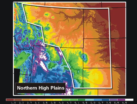
The Northern High Plains, as defined for this research effort, is outlined in the graphic below.
1.1.2 Project Objectives
The objectives of our project, Investigation of Mesoscale Convective Systems Over the Northern High Plains and Mid-Mississippi Valley, are based on the premise that the geography and climate of the Northern High Plains may engender convective storm morphologies and evolutionary characteristics which are different from their counterparts in other parts of the United States, namely, the mid-Mississippi Valley. The primary objectives include the following:
1. Study mesoscale convective systems (MCSs) that produce damaging straight-line winds over the Northern Great Plains and the Mid-Mississippi Valley
2. Expansion and enhancement of the Interactive Radar Analysis Software (IRAS) package to increase its usefulness to NWS Science and Operations Officers (SOOs) and forecasters
The study of mesoscale convective systems consists of four components:
1. To clarify the kinematics, dynamics and antecedent conditions of mesoscale convective systems, which produce severe winds over the Northern Great Plains
2. To gain a greater understanding of the evolution of storm reflectivity and Doppler velocity structure of squall lines and bow echoes which produce damaging straight line winds
3. To investigate the influence of topography (the Black Hills, for example) on the evolution of convective systems in the Northern Great Plains
4. Compare the observed structure, evolution, and antecedent atmospheric conditions of Northern High Plains storms with those in the Mid-Mississippi Valley (which are being studied by the St. Louis NWSFO)
Much of the information on the structure of convective storm systems for this and other studies will come from analysis of WSR-88D Archive Level II Doppler radar data. The IRAS package is a menu-driven software package designed for easy analysis of such radar data, and was used for several aspects of this study. This package has become widely used within the NWS and University community. IRAS related objectives include:
1. Expansion and enhancements
to IRAS to meet the needs of the proposed study
2. Expansion and enhancements of IRAS to meet the needs of the broader NWS and
university community
3. To provide support to the user community
1.1.3 Project Participants
As the NWSFO in Rapid City is located on the campus of the South Dakota School of Mines and Technology (SDSM&T), there were a great number of opportunities for the exchange of information, ideas, and data. This project was successful in bringing scientists from the SDSM&T and NWS forecasters in greater contact, and building relationships from which future coordination can be based.
The participants in this Cooperative Project included:
National Weather
Service - WFO Rapid City
Brian A. Klimowski, SOO and Principle Investigator
David Carpenter, MIC
Matthew Bunkers, Lead Forecaster and Programming Expert
South Dakota School
of Mines and Technology - Inst. of Atmospheric Science
Mark Hjelmfelt, Professor and Principle Investigator
L. Ronald Johnson, Professor
David Priegnitz, Radar Programming Expert - Developer of IRAS
Josiah Covert, Graduate student and data analyst
Nicole Radziwill, Graduate student and data analyst
Don Sedlacek, Graduate student and data analyst
Scott Rudge, Graduate student and data analyst
1.1.4 Division of Responsibilities
1.1.4.1 University Responsibilities
IRAS development and support. It was the responsibility of David Priegnitz, research scientist at the SDSM&T, to develop and support the IRAS software. Dave was originally a Principal Investigator on this project, and continued to work as a consultant while working at CIMMS on the Open Systems Development Team.
Climatological backround. Several graduate students from the SDSM&T were tasked with generating some of the climatological data, and running the SVRPLOT program to calculate severe weather frequencies
Guidance of student research. Professors Mark Hjelmfelt and L. Ron Johnson guided the efforts of the SDSM&T students.
Radar analysis with IRAS. Early in the Project, much of the radar analysis was performed with the IRAS software. SDSM&T students did these analyses.
Analysis of the pre-convective environment. A major portion of this Cooperative Project was the analysis of the pre-convective environment. This involved the identification (and modification) of appropriate soundings, calculation of many significant parameters, statistical analysis of the results. Most of this work was done as a part of the Masters Thesis of Josiah Covert.
1.1.4.2 National Weather Service Responsibilities
The NWS was responsible for the following areas of the project:
Accumulation and archiving of data. Throughout the duration of the project, a huge amount of data was collected and archived. This included radar data, surface and upper-air observations, model data, and other various information needed to completely describe the observed events.
Processing and analyzing radar data. One of the largest components of the archived data was the radar data. Radar data were collected from a variety of sources and in a variety of formats. These data were converted into viewable digital images (GIF files) for the ease of manipulation and interpretation. Loops of all significant events were created. Radar analyses performed at the NWS included the review and categorization of all events (>180), production of digital loops of data, creation of climatological plots of system location, path, etc.
Writing computational software. Several programs were written by the NWS that were needed by the project. This included a Microsoft Excel program for the production of hodographs and shear parameters, GEMPAK scripts for the visualization and production of soundings, and NTRANS scripts for the analysis and visualization of numerical model data.
1.2 Research and Development Activities and Accomplishments
1.2.1 Foundation
In order to intelligently set the framework for the research proposed in this Cooperative Project, several studies and projects were conducted during the early part of this research. These included an exhaustive climatology of the severe weather over the Northern High Plains, comparing the frequency, distribution, and temporal nature of convection in the region of interest to other parts of the country. The IRAS software was significantly upgraded during this time; and additionally, several tools were developed in order to make the processing of the meteorological data more efficient.
1.2.1.1 Severe Wind Climatology of the Northern High Plains
A large-scale climatology of severe weather over the United States was performed by Kelly et al., 1985. However, the results from this study were not appropriate to act as a foundation for this research because they did not differentiate or isolate the Northern High Plains from the rest of the Northern Plains. A simple look at the evolutionary cycle of convection over the Plains demands that this area be studied independently, because much of the convection which eventually affects the Central Plains is initiated along or near the Rocky mountains during the typical diurnal cycle.
Using the SVRPLOT software developed by Hart, 1993, a detailed climatology of the convection over the Northern High Plains was produced and summarized in Klimowski and Hjelmfelt (1998). Several significant findings were produced from this study:
1.2.1.2 Hodograph and Wind Shear Analysis Software
As the study of severe convective systems is so dependant on the analysis of vertical wind profiles, a method of displaying and analyzing the wind environment was needed. A Microsoft Excel program was written by Matthew Bunkers (Lead Forecaster, NWS Rapid City) to produce hodographs and perform analyses of the vertical wind profile (calculating shear profiles, hodograph characteristics, etc). This program was also enhanced to produce a new method of predicting supercell motion (Klimowski and Bunkers 1998; Bunkers et al., 1998; Bunkers et al., 2000), which has received wide distribution. As a significant fraction of the convective high wind-producing storms are supercells, this program served as an immediate application for forecasting these systems better.
1.2.1.3 IRAS Radar Analysis Software
The Interactive Radar Analysis Software package (IRAS; Priegnitz, 1995) was developed by David Priegnitz of the South Dakota School of Mines and Technology for the analysis of WSR-88D level II archive data from an earlier research version of the software (Priegnitz, 1993). Enthusiastic support by Ron Przybylinski (NWS St. Louis) led to its use in several NWS offices. As a response to user requests for additional features, and support, IRAS development and support was included in the COMET objectives.
During the early part of this research project, the IRAS software (Priegnitz 1995) was used almost exclusively for the perusal and analysis of radar data. Developments and enhancements performed early in this research greatly aided in the analysis of storms during the 1996 and 1997 seasons. Soon after the initiation of this Cooperative Project, David took another position with the Cooperative Institute for Mesoscale Meteorological Studies (CIMMS) with the University of Oklahoma, where he was a part of the Open Systems Radar Project Generator (SAAD) team. He continued to contribute to the Project on a part-time basis after this time. Specific enhancements that were made to the IRAS software during this Cooperative Project included (but not limited to):
Support was provided for many NWS sites, and presentations were made at SOO and WSR-88D Radar Training courses. Additional support contacts were made by a number of universities, Brookhaven National Lab, the U.S. Navy, and the National Transportation Safety Board, which has used IRAS in a number of investigations.
1.2.2 Database of Linear and High Wind Events Over the Northern High Plains, 1996-1999
One of the more significant accomplishments of this Cooperative Project was the construction of a comprehensive database of all linear and severe wind events over the Northern High Plains from 1996 through 1999. Any convective storm which produced an organized path of severe winds (more than 1 report separated by 15 or more minutes), or was linear or bow shaped (or fit the definition of squall line as in Bluestain and Jain, 1985 or Bluestain and Jain, 1987), was included in this database. As such, it includes any storm that produced severe winds, and all morphologies, which have been historically linked to severe winds (squall lines and bow echoes). The database is quickly and conveniently accessible, and includes over 185 cases from the years studied (1996 - 40 cases; 1997 - 46 cases; 1998 - 52 cases; 1999 - 48 cases). The database includes the following:
1.2.3 Morphology of the Observed Storms
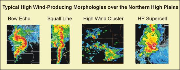
The high wind-producing storms which occurred over the Northern High Plains during the Project fell into four major categories (Hjelmfelt and Klimowski, 1997): Squall lines, Bow Echoes, Supercells, and Other (multicell). An additional category was added in 1999 in response to several non-linear cases which maintained an unusual amount of mesoscale organization and persistence, called high wind clusters. Over the four years that data was collected, 100 squall line cases were identified, 48 bow echo cases, 23 high-wind producing supercells, 4 high-wind clusters, 13 unorganized storms, and 4 of which the morphology is unknown (lack of radar data). Below are some typical examples of high wind convective events observed over the Northern High Plains.
1.2.3.1 Severe Weather Frequency - Morphology Dependence
As was shown in Klimowski and Hjelmfelt (1998), and updated herein, the proportion of severe weather from squall lines and bow echoes varied dramatically. Over 80% of the bow echoes observed produced severe winds, while only 58% of the squall lines were severe. Additionally, the ratio of severe wind and hail reports varied significantly depending on the convective morphology. Severe winds were twice as common as severe hail in squall lines, and three times as common in bow echoes. In Supercell cases, however, severe hail occurred almost twice as frequently as severe wind. For non-linear events, hail was also about twice as common as severe winds. In bow echoes, severe hail was only present about 20% of the time.
The characteristics of the observed convection over the Northern High Plains are summarized in the following table.
1.2.3.2 Distribution and Characteristics of Linear Convection and High Wind Events
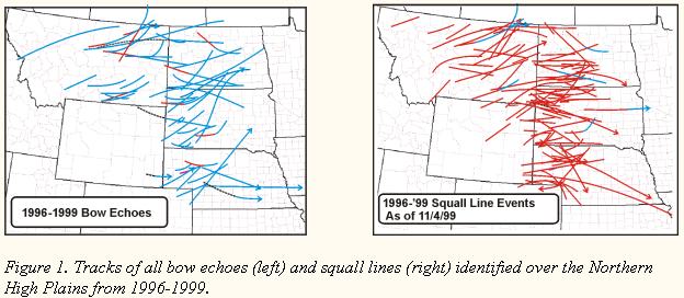
Using the accumulated radar data, the tracks of all of the linear and high wind events were analyzed and plotted. This allowed for the easy visualization of where these storms formed and how far they typically tracked. These data revealed the following insights and conclusions:
1.2.4 An Examination of High Wind-Producing Supercell Events
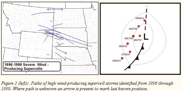
A very interesting aspect of this research was the discovery of an apparent corridor of frequent high wind-producing supercell production and occurrence. As can be shown by Figure 1 below, there has been a marked preference for these systems to form and moved through a region from southeast Montana through western South Dakota from 1996-1999. These high wind-producing supercells were frequently High Precipitation (HP) in character, and often associated with very large hail as well. Several of the most severe storms to strike the UNR CWA over the past 4 years have been storms of this nature. Study of the environment of these storms revealed that most of these supercells were initiated in a post-trough (post-frontal) environment, in northerly boundary layer flow. Figure 2 shows the position of seven of the more prominent events, which occurred relative to the surface low pressure. Note the clustering of the origin points of these systems in southeast Montana (Fig 1). A look at the topography of this region reveals that most of these systems were initiated when northerly boundary layer flow was forced to move upslope along the elevated topography of southeast Montana and Northeast Wyoming.
A particularly severe example of one of these supercells (5-6 July 1996) was the focus of a Monthly Weather Review article (Klimowski et al., 1998). This case was intriguing because it was extremely severe (50 ms-1 winds with softball-sized hail for several hours) but formed within an environment which was not extreme (that is, without excessively large CAPE or shear values). Detailed analysis of the radar imagery showed, however, that this storm propagated along the outflow from convection that had dissipated (Klimowski and Hjelmfelt, 1997). It is hypothesized that this system was able to achieve its extremely severe nature as a result of the interaction with the pre-existing outflow boundary.
1.2.5 Pre-convective Environments of Northern High Plains Severe Wind Events
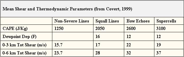
Covert (1999) looked at the pre-convective environments of the severe wind events from 1996-1998. These results were updated to include the 1999 data, and are shown in the following table. In general, there is a regular progression of shear and instability parameters from squall lines, to bow echoes, to supercell storms. As is shown in the following table, most of the high wind-producing storms occurred in an environment of at least moderate low level (0-3km) shear, and good instability (greater than 2000 J/kg of CAPE). The severe bow echoes were produced within environments that exhibited the greatest 0-3km total shear, while supercells were produced with environments, which exhibited the greatest deep (0-6km or 0-8km) shear. Squall lines, which were non-severe, formed within environments of moderate shear, but much lower CAPE, which indicates that it may be the instability that is the most frequent limiting factor in the severity of the squall lines over the Northern High Plains.
1.2.6 Evolutionary Characteristics of NHP Squall Lines and Bow Echoes
1.2.6.1 Squall Line Evolution
One of the primary objectives of this study was to look at the evolutionary characteristics of Northern High Plains squall lines. It was decided to use the established squall line evolution categories of Bluestain and Jain (1985) as a starting point for our classification. This classification had four primary modes of squall line evolution: Broken Line, Broken Areal, Backbuilding, and Embedded Areal. The table below summarizes the percentage of severe squall lines for the Bluestain and Jain study, and those observed as a part of this Cooperative Program:
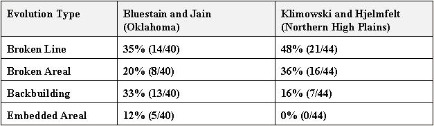
As can be seen from the table, there is a much higher percentage of storms over the Northern High Plains that fall into the Broken Line category, while no examples of the Embedded Areal evolution were identified. In addition, there were also a relatively high percentage of Broken Areal storms over the Northern High Plains, and relatively few squall lines that evolved in the Backbuilding manner. The large percentage of Broken Line type evolution may be attributed to the large percentage of organized Northern High Plains convection that is associated with surface fronts. Unlike the Southern Plains, where organized convection often breaks out in the warm sector (south of the surface low, and between the cold and warm fronts), this area is often capped by an elevated mixed layer over the Northern High Plains, and tends to suppress non-frontal induced convective morphologies.
Another significant finding of this research was a marked difference in the severity of squall lines of different evolutionary histories. Squall lines that exhibited Broken Line and Broken Areal evolutions had 70% of the severe reports coming from high winds. Squall lines that exhibited Backbuilding evolutions only had 46% of the severe reports from high winds (54% from large hail). Broken line and Broken Areal squall line evolutions have demonstrated to be more of a severe wind threat, while Backbuilding squall lines are primarily a hail threat over the Northern High Plains.
1.2.6.2 Bow Echo Evolution
A unique, and very significant aspect of this research was the attempt to classify the evolution of the bow echoes that were observed during the Project. Of the 48 bow echoes which were observed from 1996 through 1999:
41% of the bow echoes evolved from areas, or groups of cells.
31% of the bow echoes evolved from squall lines.
28% of the bow echoes evolved from supercells.
It is interesting to note that a relatively small percentage of the bow echoes exhibited the classical evolution from squall lines. Rather, the majority of the bow echoes evolved from groups of cells or storms that interacted in such a way (within a favorable environment) that produced the bowing structure. Close examination of the evolution of the bow echoes demonstrated that 31% of all bow echoes were formed as the result of a cell or storm merger. It is hypothesized that the merging of two storms, each with sufficient storm-scale dynamic organization alone, may lose the ability to support the combined lofted hydrometeor mass of the two storms upon merging due to the disruption of the updrafts in the storms. As the hydrometeors (which are no longer able to be supported through some organized updraft structure) fall to the ground, a great amount of evaporatively cooled outflow is produced. In this way, a storm may quickly evolve into an outflow-dominated storm. Within a favorable (highly sheared) environment, a very severe and long-lived convective structure may result. One could envision that convective mergers may force a system into a more steady or favored convective organization faster than it would have evolved into it otherwise.
1.2.6.3 Influence of topography (Black Hills) on Squall Line Evolution
As has been mentioned previously, most storms observed in this study were initiated over or to the east of the Plains / Mountain interface. However, several squall lines were observed to form over Wyoming, and move across the Black Hills. Study of these cases revealed that the depth of moisture was critical to the evolutionary behavior of the system as it moved across the higher topography. If the boundary layer moisture was limited, then the line tended to dissipate over the Black Hills (but be maintained to the north and south of the Hills), and regenerate to the east. If the boundary layer moisture was greater, the line tended to maintain its structure during the passage over the Black Hills.
2. SUMMARY OF UNIVERSITY / NWS EXCHANGES
In 1996:
Several SDSM&T scientists came to the NWS and gave presentations on important aspects of forecasting in the Black Hills region. This information was very important to our new staff of forecasters and interns at the recently created Rapid City office.
Brian Klimowski [NWS] served on the search committee for the new Director for the Institute of Atmospheric Sciences.
Five SDSM&T students participated in the COOP Student Volunteer Program. This program requires that a student spend 60 hours at the NWS office, 30 of which is used learning the basic operations of the NWS, and the remaining 30 hours on some project of benefit to the student and the NWS.
Dr. Brian Klimowski manages the Cooperative Student Volunteer program. Brian Klimowski served on a graduate Masters committee.
David Priegnitz came to the NWS office and demonstrated the Interactive Radar Analysis Software for the NWS staff.
In 1997:
The SDSM&T and NWS Rapid City developed and hosted the 1997 Workshop on Northern High Plains Convective Storms, which was held on the campus of the SDSM&T on 1-2 May 1997. Over 60 people attended this workshop with participation by five NWS offices, the Air Weather Service from Elsworth AFB, NSSL-OSF, COMET (Wendy Abshire), the South Dakota School of Mines and Technology, the University of Wyoming, and local TV broadcasters. Four NWSO Rapid City personnel and six researchers from the SDSM&T gave presentations at the workshop. A preprint volume including abstracts and figures from all of the presentations was constructed and distributed to all attendees.
Dr. Klimowski taught several classes at the SDSM&T, filling in occasionally when professors have been unable to teach their courses.
Dr. Klimowski also gave a seminar at the SDSM&T in December 1997, addressing several particularly hazardous aspects of High Plains convection.
Five SDSM&T students participated in the COOP student volunteer program at the NWS.
Several tours of the NWS were given to classes and groups at the SDSM&T. During 1997, tours of the office were given to the Radar Meteorology and Introduction to Meteorology classes at the SDSM&T. In addition, a special program was prepared for the radar meteorology class, with several severe weather case studies loaded onto the computers, and discussion of the warning decision making process in relation to the observed radar data.
Two NWS employees took classes at the SDSM&T during 1997: Jon Zeitler (forecaster), and Treste-Huse (Hydrologist).
Mark Hjelmfelt installed and gave instruction on the running of the Black Hills Mesoscale Model on the NWS Science Applications Computer (SAC).
In 1998:
Brian Klimowski served on the Thesis Committee for Josiah Covert.
Four SDSM&T students participated in the COOP student volunteer program at the NWS.
The NWS and SDSM&T cooperated on several research projects, jointly presenting research at the Northern High Plains Convective Workshop in Aberdeen and the Severe Storms Conference in Minneapolis.
SDSMT faculty and students further helped with several runs of the Black Hills Mesoscale model, investigating primarily upslope-forced precipitation.
In 1999:
Brian Klimowski served on the Thesis Committee for Josiah Covert.
Three SDSM&T students participated in the COOP student volunteer program at the NWS. Matthew Bunkers and Brian Klimowski helped set up the SDSM&T NTRANS software. Scripts that were used at the NWS Rapid City were installed for use at the SDSM&T.
The SDSM&T and NWS Rapid City coordinated in reorganizing the Black Hills Chapter of the AMS. Two meetings were held in 1999.
NWS Forecaster Matthew Bunkers and SOO Brian Klimowski configured NTRANS and GEMPAK to run on the SDSM&T computer system.
The NWS and SDSM&T cooperated on several research projects, jointly presenting research at the Northern High Plains Convective Workshop in Bismarck.
3. PRESENTATIONS AND PUBLICATIONS
3.1 Publications
Klimowski, B. A. and M. R. Hjelmfelt, 1997: WSR-88D Analyses of an extreme HP supercell event over the Northern High Plains. Preprints, 28th Conf. On Radar Meteorology, Austin, TX, Amer. Meteor. Soc., 547-548.
Hjelmfelt, R. M., and B. A. Klimowski, 1997: Radar characteristics of high wind producing mesoscale convective systems over the Northern High Plains. Preprints, 28th Conf. On Radar Meteorology, Austin, TX, Amer. Meteor. Soc., 590-591.
Klimowski, B.A., M.R. Hjelmfelt, M.J. Bunkers, D. Sedlacek, and L. R. Johnson, 1998: Hailstorm damage observed from the GOES-8 satellite: The 5-6 July 1996 Butte-Meade storm. Monthly Weather Review, 126, 831-834.
Klimowski, B. A., and M. R. Hjelmfelt, 1998: Climatology and structure of high wind- producing convective systems over the Northern High Plains. Preprints, 19th Conf on Severe Local Storms, Minneapolis, MN, Amer. Meteor. Soc., 444-447.
Bunkers, M. J., B. A. Klimowski, J. W. Zeitler, R. L. Thompson, and M. L. Weisman, 1998: Predicting supercell motion using hodograph techniques. Preprints, 19th Conf on Severe Local Storms, Minneapolis, MN, Amer. Meteor. Soc., 611-614.
Bunkers, M. J., B. A. Klimowski, J. W. Zeitler, R. L. Thompson, and M. L. Weisman, 1999: Predicting supercell motion using hodograph techniques. Accepted for publication in Wea. and Fore.
Bunkers, Matthew J., 1999: Predicting supercell motion using hodograph techniques. COMET Web cast at http://meted.ucar.edu/convectn/ic411/index.htm.
Covert, J. N., 1999: Pre-storm environments of Northern High Plains severe wind events. M.S. Thesis, Department of Atmo. Sci., South Dakota School of Mines and Technology, Rapid City, SD, 148 pp.
3.2 Presentations:
At the 1st Annual Workshop on Northern
Plains Convective Storms (Bismarck, ND; 1996)
-Brian A. Klimowski and Mark R. Hjelmfelt: An introduction to the SDSMT / NWS
Cooperative project on Convective High Windstorms.
At the Workshop on Northern High
Plains Convective Storms (Rapid City, SD; 1997):
- Brian A. Klimowski [NWS - Rapid City]: An overview of the 5-6 July 1996 extreme
HP supercell hail/wind event.
- Matthew Bunkers [NWS - Rapid City]: The 14 June 1996 supercell/flash Flood
event
- L. Ronald Johnson [SDSM&T]: Use and abuse of the Interactive Radar Analysis
Software (IRAS).
- Mark R. Hjelmfelt [SDSM&T]: The July 17 NDTP squall line case study.
At the 28th Conference on Radar
Meteorology (Austin, TX; 1997):
- Brian A. Klimowski [NWS - Rapid City]: WSR-88D Analyses of an extreme HP supercell
event on the Northern High Plains.
- Mark R. Hjelmfelt [SDSM&T]: Radar characteristics of high wind producing mesoscale
convective systems over the Northern Great Plains.
At the 2nd Workshop on High Plains
Convective Storms (Grand Forks, ND; 1997):
- Andy Detweiler and Trace Bowen [SDSM&T]: Forecasting storm structure from
environmental parameters.
At the AAAS Conference on Networking
Resources for Competitive Earth Systems Science (Sioux Falls, SD; 1998):
- Mark R. Hjelmfelt [SDSM&T]: Highlights of COMET programs and work at the SDSM&T.
At the 3rd Annual Workshop on Northern
Plains Convective Storms (Aberdeen, SD; 1998):
- Brian A. Klimowski [NWS]: On the characteristics of quasi-stationary storm-scale
convective events over western South Dakota.
- Brian A. Klimowski [NWS]: Predicting supercell motion using a new hodograph
technique.
At the 19th Conference on Severe
Local Storms (Minneapolis, MN; 1998)
- Brian A. Klimowski [NWS] and Mark R. Hjelmfelt [SDSM&T]: Climatology and structure
of high wind-producing mesoscale convective systems over the Northern High Plains.
At the 4th Annual Workshop on Northern
Plains Convective Storms (Bismarck, ND; 1999)
- Brian A. Klimowski [NWS]: Some interesting aspects of high wind-producing
MCSs over the Northern High Plains.
- Josiah Covert [SDSM&T]: Pre-convective environments of severe wind events
over the Northern High Plains.
At the 2nd COMET Cooperative Regional
Workshop (St. Louis, MO; 1999)
- Brian A. Klimowski [NWS]: On the nature and environments of high wind producing
convective systems over the Northern High Plains.
At the Symposium on the Mystery
of Severe Storms: A Tribute to the Work of T. Theodore Fujita (AMS Annual Meeting)
(Long Beach, CA; 2000)
- Brian A. Klimowski [NWS], J. Covert, and Mark R. Hjelmfelt [SDSM&T]: High
wind-producing convective systems over the Northern High Plains
4. SUMMARY OF BENEFITS AND PROBLEMS ENCOUNTERED
4.1 Benefits to the University
4.2 Benefits to the NWS
The COMET collaboration with the SDSM&T has produced many benefits for the NWS. Among the most significant benefits would be:
4.3 Problems Encountered
During the span of this cooperative research, no significant problems or obstacles were encountered which could not be adequately resolved. A high level of communication between the participants during all phases of the research aided in the diminution of potential problems.