EXECUTIVE SUMMARY OF PROJECT OBJECTIVES s
The objective of the flash flood forecasting cooperative program at UH is to focus research efforts in the Meteorology program at UH and at the WFO HFO to achieve the goals listed below. These research efforts in some cases have alternate lines of support (e.g., NSF, ONR, etc.) and represent efforts that, in some cases, predate the cooperative. Project goals are to:
(i) optimize the utility of the new observing systems as data resources for flood forecasting.
(ii) conduct case studies and climatological analyses of flood events and develop better conceptual models of the tropical weather systems that produce flooding,
(iii) promote development of a high-resolution mesoscale numerical model capability that uses NCEP GSM data as initial conditions, with regional data enhancement,
(iv) use NWS National Centers and GPS data streams to develop diagnostic forecasting tools and algorithms that focus on the mesoscale/nowcasting aspect of flood forecasting, and
(v) promote the exchange of information and understanding concerning flash flood forecasting in the tropics.
This final report is an overview of all activities and progress toward these goals for the duration of the three-year cooperative project.
1. OPTIMIZING THE UTILITY OF THE NEW OBSERVING SYSTEMS
1.1 POES and GOES-10 satellite
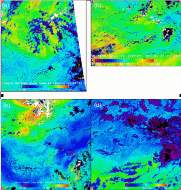
Craig Motell and John Porter with support from NASA have developed a new water vapor algorithm for satellite data. The satellite retrieval method is based on the split-window technique in which the difference in absorption between two nearby infrared channels, channels 4 and 5 of the AVHRR sensor flown on polar orbiter satellites, is used to estimate the total column water vapor or precipitable water (PW). The greater the difference between channels 4 and 5 brightness temperatures, the more water vapor found above the pixel whose brightness temperatures are being measured. The images shown in Fig. 1 are an estimate of total column water vapor (in mm). The "length" unit is used and suggests that if all the water vapor in a unit area column of the atmosphere were condensed, then the condensed water would have a height in millimeters equivalent to the total column water vapor. The resulting images have been posted daily at http://www.soest.hawaii.edu/porter/wv_dir/images/.
PW gradients associated with tropical disturbances and approaching frontal systems provide spatial information of significant value to the forecaster. The distinction between "wet" and "dry" trade wind regimes also is apparent in the PW data. Waves seen in the wake of Oahu in the PW imagery have a possible serendipitous use for diagnosing clear air turbulence (Fig. 1d). During this period, the trade winds were stronger than normal and the trade wind inversion lower than usual. A region of higher integrated water vapor is seen to the south indicative of a more moist air mass in the trade winds. Gravity waves can be seen drifting off Oahu which are not causing clouds but are lowering and raising the trade wind inversion enough to cause changes in the integrated water vapor.
Up until Dec. 1999, we were processing AVHRR images in real time to derive integrated water vapor images (see http://www.soest.hawaii.edu/porter). Due to Y2K software bugs, our source of satellite images has discontinued collecting AVHRR images. We are now writing new software to process AVHRR and GOES images collected by the National Weather Service and by Torben Nielsen (UH). We anticipate this will be running by summer 2000.
Fig.
1 Images of integrated water vapor (mm) in the vicinity of Hawaii
derived using
the split-window method, showing (a) the remnant of
a tropical storm, (b) vapor plumes in the wake of the islands, (c) variations
of integrated water vapor in trade wind flow, and (d) waves visible in
the lee of Oahu and Kauai associated with gravity waves propagating
along the tradewind inversion.
The split window techniques we have used are based on the literature. We have also tested these approaches and find the satellite agrees with soundings and GPS derived column-integrated water vapor to within 3.3 mm RMS (Motell et al., 1999). We plan to carry out further comparison studies to test water vapor algorithms for the GOES and AVHRR split window methods, microwave satellites (which are more accurate), and GOES water vapor channels which provide upper level water vapor. As different instruments come on line, the satellite-derived water vapor measurements will be compared with DIAL lidar and surface and mountain top GPS measurements.
1.2 Global Positioning System (GPS)
A network of continuously operating GPS receivers, including a growing number of receivers outfitted with surface instrument packages, has been constructed across the State of Hawaii by Drs. Michael Bevis and Steven Businger for a combination of geodetic and meteorological purposes. The Pacific network development has combined funding from NASA, NSF, and NOAA (Bevis et al. 1992, 1994; Businger et al. 1995; Duan et al. 1995) (Fig. 2). Current sites outfitted with barometers include Oahu at sea level, Haleakala at 10,000' on Maui, six on the Big Island, including sites at Hilo and Mauna Kea. Kauai has a site at Lihue open to the NE trade winds. The data being collected at these sites are being transmitted by fiber optic link, and column-integrated water vapor amounts are being derived with an accuracy of ~ 1 mm precipitable water.
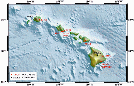
Fig. 2 Location of GPS
water vapor sites in Hawaiian Islands.
The application of GPS water vapor time series in forecasting has been awaiting the development of accurate real-time processing of the GPS data. Recent advances have made accurate GPS precipitable water data available in real time for applications in nowcasting and assimilation into NWP models. One approach is to use a sliding window to process the GPS data (Fig. 3). A second new approach to processing GPS data in real time has emerged for networks with baselines of ≤40 km. Dr. Bevis and Dr. Businger have NASA funding to develop a finely spaced network of ~12 GPS receivers on Oahu. Once the network is fully operational (summer 2000) we will test the impact of the data in sensitivity studies using MM5. In the interim, Rob Mazany, an MS student, is investigating the use of the real-time PW data as a nowcasting tool for flash flooding.
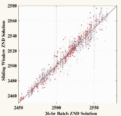
Fig. 3 Top panel shows
a comparison of GPS zenith neutral delay (ZND) data processed
using a sliding
window approach and a standard batch approach. A13 mm ZND ~ 2 mm
error in precipitable water. The red dots show the real time solution,
blue and gray dots
show remaining solutions for the window.
Climatological analysis of the GPS PW time series has been undertaken, including calculations of diurnal cycles, monthly means, and power spectra. A short time series of column-integrated (precipitable) water vapor measured with the GPS technique is shown in Fig. 4. These measurements were made at Haleakala, Maui (~3 km elevation) and at Lihue, Kauai (close to sea level). As expected, the surface site has larger integrated water vapor and larger fluctuations. A longer time series of column integrated water vapor is shown in Fig. 5. The Mauna Kea, Hawaii site is located at 3.5-km altitude and the Kokee Park, Kauai site is located at 1-km altitude. These long-term measurements illustrate changes caused by both seasonal and El Niño cycles. The column-integrated water vapor measured at Kokee Park site (Fig. 5) is slightly lower than values measured at Lihue, Kauai (Fig. 4) because Kokee Park is 1 km above sea level. The GPS data from Hilo, Lihue, Maui and Honolulu are being provided to the IGS (International Geodynamics Service) and can be obtained there. Time series of water vapor are also being put on a web page for public access in the near future.
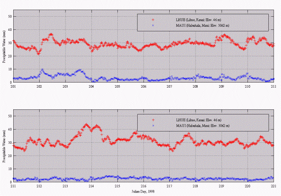
Fig. 4 Time series
of integrated water vapor at Lihue, Kauai (surface site) and Haleakala,
Maui (mountain top site).
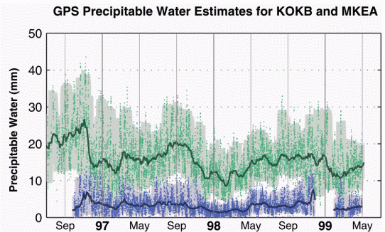
Fig. 5 Time series
of integrated water vapor measured from Mauna Kea, Hawaii (blue) and Kokee
Park, Kauai (green).
Papers on our
GPS meteorology results were presented at the Annual AMS meeting in Phoenix,
the spring AGU meeting in Boston in May and at the precipitation workshop
in Hawaii in June (Bevis et. al. 1998; Foster et al. 1998; Businger et al.
1998a).
(iii) WSR-88D
Tom Birchard has completed his research effort using the WSR-88D data. The following is a summary of his findings.
Observed rainfall rates (R) from 11 telemetered raingages are compared to precipitation estimates based on radar reflectivity (Z) during a heavy rain event on Oahu. Radar reflectivity was measured by the WSR-88D (Weather Surveillance Radar-1988 Doppler) located on Molokai, approximately 75 km away. This was done to evaluate radar rainrate algorithms, and to identify circumstances, other than the choice of Z-R relationship, that may have resulted in inaccurate radar rainfall estimates.
Fifteen minute raingage observations were compared to averaged fifteen minute radar precipitation estimates in order to evaluate the performance of three Z-R relationships, the WSR-88D default of Z=300R1.4, and the tropical maritime relationships of Z=250R1.2 and Z=139R1.43. Nine radar bins over each raingage were examined, and the gage most directly over the gage was named the primary radar pixel (PRP), the radar bin that had an accumulation closest to the gage value was named the best, and the average of the nine was also examined. Fifteen-minute resolution comparisons of the average and PRP values indicate little difference between the correlation coefficients for the three Z-R relationships, but when hourly accumulations were compared, the tropical maritime Z-R relationships yielded rainfall totals closer to those observed by raingages (Fig. 6). Examination of the best of the nine radar bins surrounding the gage indicated a high correlation between the fifteen-minute resolution radar estimated and gage observed rainfall rates for both of the tropical maritime Z-R relationships. Operationally, the problem lies in the identification of the best bin in real-time. Results show that the bin located downwind of the gage as determined through the VAD wind profile, is most likely to give the best correlation with the gage data (Fig. 7). Orography may also have an influence on the location of the best bin.
The tropical Z-R relationship Z=250R1.2 is currently employed on all of the Hawaiian WSR-88Ds and other user adjustable parameters have also been tested and changed to more accurately portray rainfall accumulations in Hawaii. These include changes to the maximum precipitation rate allowed (MXPRA), the maximum reflectivity associated with liquid precipitation (MXRFL) and the maximum reflectivity (MXDBZ) value considered in rainfall algorithms.
Future efforts will center on using the gage data to diagnose the accuracy of the radar rain retrieval algorithms and adjust them as needed in real time. Due to considerations of complex terrain, the algorithms will need to evaluated and adjusted taking into account the results for each rain gage.
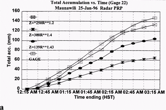
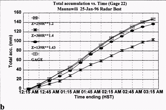
Fig.
6 Gage and radar estimated total rainfall accumulation at Maunawili (gage
22) as a
function of time for various Z-R relationships. (a) Primary radar pixel
(PRP) and (b) best.
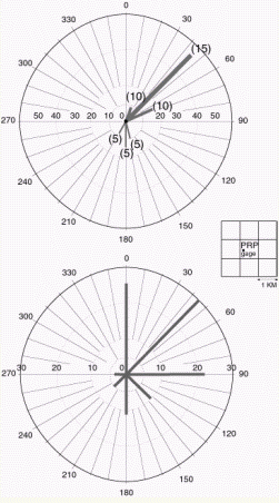
Fig.
7 (a) Length of gray bars indicates number of VAD winds with given direction.
Width of bar and (#s) indicates mean wind speed for lowest elevation angles.
(b) Length of gray bars indicates number of times the best radar pixel occurs
in
a particular quadrant relative to the primary radar pixel (PRP) located
over the gage.
2. Case Studies and Climatological Analyses
(i) Bow Echo Case Study
On 2 November 1995 a kona low formed to the northwest of the island of Hawaii. During the following 48 hours, a series of convective rainbands developed on the southeastern side of the low as it slowly moved eastward. On the afternoon of 3 November 1995 a bow echo signature was identified in reflectivity observations from the recently installed WSR-88D located on the south shore of Kauai, and led to the first severe thunderstorm warning with lead time ever issued by the National Weather Service Forecast Office in Honolulu, Hawaii (Fig. 8). Subsequent to the warning, winds of 40 m s-1 (80 kt) were observed at Nawiliwili Harbor on the southeast side of Kauai. In Businger et al. 1998, the environmental conditions that led to bow echo formation in Hawaii were studied and contrasted with investigations of similar phenomena in the midlatitudes and tropics. A discussion of the impact of data from the new observing systems in forecasting severe weather in the central Pacific is provided for this case and similar events in the future. Please see the attached reprint for reference.
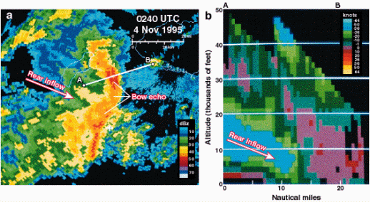
Fig. 8 (a) WSR-88D radar
reflectivity PPI at 0.5-elevation angle, showing a well-defined bow echo
approaching Kauai. White arrow indicates the position of the bow echo. (b)
RHI of Doppler winds
along black line "AB" in 8a; white arrow shows axis of descending rear inflow
jet.
(ii) Kona Low Case Study
Ian Morrison has completed a detailed case study using all available operational data on the kona low that affected the Big Island of Hawaii during the last week of February 1997. It produced record winds, blizzard conditions, high surf, thunderstorms, and hail on the east end of the Hawaiian Island chain causing damage upwards of four million dollars. The research presented in Ian's completed thesis focused on the large-scale aspects of the evolution of this kona low with the aid of data from operational sources and the NCEP/NCAR Reanalysis Project. The analysis was undertaken at 6-hour intervals during the life cycle of the kona low.
Significant findings from this study are summarized here. Cloud bands with embedded convective cells characterized the mature kona low. The cloud bands formed on the low's eastern side and propagated eastward, eventually leaving the area of synoptic scale ascent and losing their convective properties. Later in the life cycle, the cloud bands were less organized and convection appeared more isolated in the satellite imagery. Areas where the best-lifted index value was less than zero and areas of positive low-level advection of equivalent potential temperature coincided with regions of deep convection, as inferred from satellite imagery (Fig. 9), providing a useful guide for forecasters.
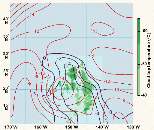
Fig. 9 Best lifted index
(bold lines ≤ 0 ˚C), 500-mb temperature (thin lines, ˚C),
and IR satellite temperature
(shading every -8˚C starting at -40˚C)for 1200 UTC26 February
1997. L indicates the position of the
observed surface low, and the large arrow indicates the low's track to the
next stage.
A north-south oriented jet streak aloft was the mechanism for genesis (Fig. 10). The jet streak occurred in the trailing side of a developing upper-level trough and enhanced winds remained on the west side of the vortex during the kona low's life cycle. The winds remained strongest on the west side most likely due to the pressure gradient created by the circulation propagating towards an upper-level ridge to the west. Consistent with a synoptic-scale baroclinic system, the divergence field aloft was closely linked with the ageostrophic component of the wind field. The 250-mb level exhibited the strongest absolute vorticity values and the greatest height anomalies, contrary to previous analysis that emphasized the 500-mb circulation. The greatest temperature anomaly (T') occurred along a vertically tilted axis extending from 250 to 850 mb. During the growth stages the axis of the negative T' intersected the vertical plane of the surface low in the mid-troposphere and during the decaying stages the axis of T' intersected near the surface. At the surface the isotherms showed a lack of baroclinicity, consistent with the equalizing influence from subtropical ocean surface fluxes on the cool-air side of the storm circulation.
Horizontal vorticity advection and vorticity generated by divergence were the two major terms that contributed most to the absolute vorticity tendency. The divergence term dominated the vorticity tendency in the lower troposphere (<500 mb), especially during the growth stages. Horizontal vorticity advection played an equal role with the divergence term in the upper tropospheric vorticity tendency for all stages. Divergence profiles showed a well-defined level of non-divergence at 500 mb during the growth stages with low-level convergence and upper-level divergence. Later stages were characterized by smaller values of convergence and divergence, and the level of non-divergence is indistinct.
Whereas the rainbands tracked eastward, the kona low tracked westward from the intensifying stage onward. Quasi-geostrophic analysis at midtropospheric levels showed an area of upward forcing extending to the west of the low at all times (except the final stage) during the life cycle of the low, supporting the westward motion of the low. Overall, the Rossby-wave dispersion relationship does a very good job of predicting the zonal propagation speed of the kona low.
A manuscript based on the work has been submitted to W&F. A track-forecast tool described in the thesis will be tested on kona lows that develop during the coming winter season.
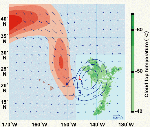
Fig.
10 Actual (large arrowhead), geostrophic (small arrowhead), and ageostrophic
(bold)
winds (vectors, m/s), at 250 mb for the Intensifying Stage, 1200 UTC 24
February 1997.
Actual winds greater than 50 m/s are shaded (isotachs, every 10 m/s); IR
satellite temperature
is also shaded (every 8 degrees Celsius). L indicates the position of the
observed surface low.
(iii) Hawaiian High and Storm Force Trade Winds
A case study and climatology effort to understand the large-scale evolution of the Hawaiian High and storm force trade winds has been completed as a Masters Thesis by Chris Mello. As with the kona low case, initial evidence for the development of a strong high resides at the 250-mb level. Large positive height anomalies precede the events by 48 hours, providing forecasters with a viable early warning.
Preliminary Results
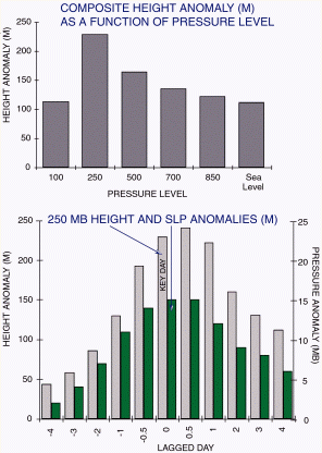
Fig. 11 (a) Histogram
of composite height anomalies as a function of pressure level.
(b) Sea level pressure and 250-mb height anomalies plotted as a function
of lagged day.
Ongoing Research
3. Development of a Mesoscale Modeling Capability for Hawaii
During the first half of the cooperative project, the mesoscale modeling effort focused on implementation of the RSM. The hydrostatic version of the RSM with nest grids of 25 and 10 km resolution has been successfully run for a number of case studies on the UH DEC "Vortex" workstation. The results of these case studies are reported in Businger et al. 1998 and Wang et al. 1998.
The operational implementation of the NCEP Regional Spectral Model (RSM) in Hawaii is the first application of a mesoscale model to improve weather forecasts in the Pacific Region. The primary model guidance for National Weather Service Pacific Region has been provided by the NCEP Aviation (AVN) run of the Global Spectral Model (GSM). Three recent synoptic-scale disturbances that affected the Hawaiian Islands were selected to demonstrate the potential utility of model guidance produced by the RSM and contrast it qualitatively with that from the AVN. Large-scale weather systems, such as the cases selected for study, are responsible for a number of potentially hazardous weather events in the Hawaiian Islands, including heavy rainfall, flash floods, high winds, and large surf. Although the overall synoptic-scale patterns of the chosen cases are reasonably well simulated by the GSM, attendant hazardous weather is organized largely on the mesoscale and is not well predicted by the global model.
NCEP RSM simulations, with enhanced grid resolution, can better resolve convective rainbands and the interaction between the environmental airflow and the complex island topography, features the GSM cannot capture. Low-level winds simulated by the RSM show many of the observed mesoscale flow patterns, including deceleration of incoming airflow in the region upstream of island obstacles, flow splitting and acceleration around the islands of Maui and Hawaii, whose peaks reach above the trade-wind inversion, vortices in the lee of the island of Hawaii, and the condensation of moisture and rainfall in the upslope flow on the windward side of the islands. In addition, diurnal land-sea breeze circulations are present in the RSM simulations when the influence from synoptic-scale forcing is weak.
RSM model performance in reproducing mesoscale structures associated with the synoptic-scale systems is encouraging. For the first simulation, a kona low case on 3 November 1995, the RSM predicted a northeast-southwest oriented rainband that closely matched a convective cloud band in the satellite imagery and maximum rainfall over Kauai. The second RSM simulation, a cyclogenesis event on 3 March 1996, shows remarkable agreement with observations. Important features such as the heavy rains and high winds over portions of Maui and Hawaii are accurately forecast. The third RSM simulation, a heavy rain event on 13 November 1996, is associated with convergence along a trailing cold-frontal trough. In this case the RSM correctly forecast the timing and distribution of heavy rainfall on the island of Oahu.
Subjective comparisons between RSM output and observations demonstrate the potential utility of the model guidance for local weather forecasts in Hawaii.
Evaluation of RSM Performance and Utility
Kevin Kodama has undertaken a quantitative effort to validate the RSM performance in Hawaii (Kodama and Juang 1998). Preliminary results indicate that the RSM wind forecasts show improvement when compared with the Global Spectral model winds at sites on the Big Island, however, RSM forecast winds are less accurate for on Maui and Oahu, most likely because of the smaller scale terrain features on these islands and the limited 10 km resolution of the RSM grid. Nevertheless, because of the skill that RSM boundary layer wind forecasts have shown in the vicinity of the Big Island, forecasters regularly consult the RSM output in making wind forecasts for Alenuihaha Channel and near South Point. RSM output has also proven useful in tracking moisture plumes near the Hawaiian Islands (R. Farrell, personal communication).
Dave Chen (UH) and Kevin Kodama (NWS) are continuing the RSM agenda. Dave has a separate Cooperative Project and Dr. Chen will provide additional information regarding ongoing research and progress with the RSM in his annual report.
Implementation of NCAR/Penn State MM5
During the last half of this cooperative project, we have commenced a parallel mesoscale modeling effort based on the NCAR/Penn State MM5. In 1999 a new project to provide custom forecast support to astronomical observatories in Hawaii was undertaken (Businger et al. 2000). The telescope infrastructure that resides on Mauna Kea, Hawaii represents an investment >$500 million. The astronomical community that oversees the use of this infrastructure has collectively committed to ongoing support for a custom forecasting program and modeling project to optimize the return from their considerable investment. The NCAR/Penn State MM5 was adopted as the high-resolution model to run operationally over the central Pacific. MM5 version 3 is Y2K compliant, has been ported to run on multiprocessor supercomputers, has excellent I/O data management characteristics, and has broad support from the scientific community.
Rick Knabb has implemented MM5 to run on a 24-node Fujitsu Supercomputer located at the Subaru Observatory in Hilo, Hawaii. Since 3 July 1999, MM5 simulations have been run operationally once daily. The model is initialized at 00 UTC and completes a 48-hour simulation overnight in ~ six hours, with graphical output available by 18 UTC, in sufficient time for operational use (Fig. 12). The simulations are non-hydrostatic on four two-way nested domains with horizontal resolutions of 27, 9, 3, and 1 km (Fig. 13). The model utilizes a terrain-following sigma coordinate in the vertical and has 26 vertical levels, with a top level of 50 mb. Thirty-second USGS terrain, land use, and land-water boundaries are used. Initial and outer domain boundary conditions at 6-hour intervals are from the 00 UTC AVN forecast through 48 hours. The model includes mixed phase resolved-scale moisture physics (water and ice can exist simultaneously) and a Grell cumulus parameterization in domain 1 (27 km) and domain 2 (9 km) (Fig. 13). The model includes a high resolution MRF boundary layer and a radiation scheme allowing for longwave and shortwave interaction with clouds and water vapor. It is anticipated that additional computer resources will become available at Subaru, in which case the configuration of the nested domains will be optimized, extending the higher resolution (3 km) nest across the major islands in the Hawaiian chain.
4. Development of Diagnostic Forecasting Tools and Algorithms.
Preliminary progress has been made in the development of a diagnostic tool based on buoy pressure data to help predict the onset of high trade-wind events. Additional work with a larger sample of cases and use of MM5 model output is planned.
A tool has been developed to predict the zonal motion of Kona lows, based on Rossby wave theory. This tool will be tested during the coming winter season.
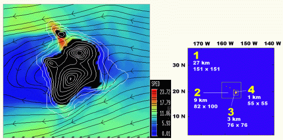
Fig. 12 Left panel shows
MM5 12-hour simulation of a high wind event on 24 August 1999, showing wind
speeds (color bar in kt) and streamlines at 1-km elevation above mean sea
level on the Island of Hawaii. The right panel shows the configuration
of four MM5 nested grids.
Efforts at developing forecast tools from case-study results and using GPS time series data are ongoing. Rather dry conditions since the availability of the GPS PW data have slowed efforts in this area. A la Niña winter in Hawaii is resulting in a wetter winter and a more robust rainfall data set is expected by spring 2000.
COMET collaboration aims to compare LARC rain gage data with high-resolution radar data for application to the Areal Mean Basin Estimated Rainfall (AMBER) algorithm (Davis and Jendrowski 1996; Jendrowski and Davis 1998). Relationships between areal mean basin estimated rainfall and streamflow response are targeted for future development. At this time no specific student has been assigned to these high-priority efforts.
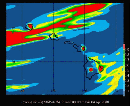
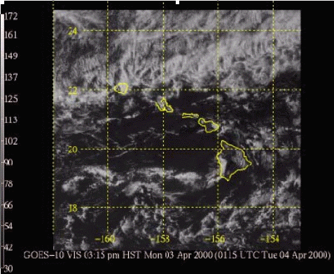
Fig. 13 Comparison
of MM5 24-hour precipitation forecast and 1 km visible satellite imagery
for 3 April 2000.
5. Information Exchange and Dissemination
Given the ideal co-location of the WFO HFO on UH campus (within the same building), attendance of the Meteorology Department Seminar series by the NWS staff has been very good. In addition numerous informal presentations have been given by UH faculty and students at the NWSFO. Activation of a National Chapter of the AMS has led to additional opportunities for presentations and exchange. These meetings take place at the WFO HFO and John Porter has presented some of his satellite PW results and I have given a presentation on windstorms associated with the Hawaiian high and one on kona lows to forecasters. A list of seminar presentations and informal talks is available upon request.
Dr. Businger's VISIONLAB currently includes the following computing resources available to the collaboration.
Additional computing resources are available to support the project in the UH Meteorology Department and at Subaru in Hilo.
Publications Associated with Previous COMET Funding
Businger, S., T. Birchard, Jr., K.R. Kodama, P.A. Jendrowski, and J-J Wang, 1998: A bow echo and severe weather associated with a Kona Low in Hawaii. Wea. and Forecasting, 13, 576-591.
Kodama, K.R. and S. Businger, 1998: A Brief Overview of Weather and Forecasting in the Pacific Region of the National Weather Service. Wea. and Forecasting, 13, 523-546.
Wang, J.-J., H.-M. Juang, S. Businger, K. Kodama, Y.-L. Chen, and J. Partain, 1998: Application of the NCEP Regional Spectral Model to improve mesoscale weather forecasts in Hawaii. Wea. and Forecasting, 13, 560-575.
Businger, S., S.R. Chiswell, M. Bevis, J. Duan, R. Anthes, C. Rocken, R. Ware, M. Exner, T. VanHove, F. Solheim, 1996: The promise of GPS in atmospheric monitoring. Bull. Amer. Met. Soc., 77, 5-18.
Kodama, K. and G. M. Barnes, 1997: Heavy rain events over the south-facing slopes of Hawaii: Attendant conditions. Wea. and Forecasting, 12, 247-267.
In Press or Review
Businger, S. and C. Mello, 2000: Damaging windstorms associated with an enhanced Hawaiian high. Mon. Wea. Rev., In review.
Foster, J, M. Bevis, T. Schroeder, M. Merrifield, S. Businger, S. Dorn, S. Marcus, J., Dickey, Yoaz Bar-Sever (2000) El Niño, Water Vapor, and the Global Positioning System, GRL, In press.
Motell, C., J.N. Porter, M. Bevis, and S. Businger (1999) Comparisons of Water Vapor Derived from GPS, Sounding and the Split Window Technique , Applied Optics, In review.
Morrison, I. and S. Businger, 2000: The dynamic structure and evolution of a kona low. Wea. and Forecasting, In press.
MS Thesis Completed in Collaboration with REAPP
Clark, James D., MS, Dec-98 Interannual Variability of Tropical Cyclones in the Central North Pacific
Birchard, Thomas R., MS, Aug-99 Investigation of Radar Reflectivity - Rainrate Relationships in Hawaii
Mello, Christopher, MS, Aug-99 Damaging Trade Winds in Hawaii
Morrison, Ian, MS, Aug-99 The Structure and Evolution of a Kona Low
Preprints and presentations
Businger, S. and Morrison, I. J., 1999: The Synoptic Structure and Evolution of a Kona Low. Presented at the 24th Conference on Hurricanes and Tropical Meteorology, Ft. Lauderdale, FL, May 2000.
Businger, S. 1999: Progress in GPS Meteorology, Invited presentation at the Second AGU Chapman Conference on Water Vapor in the Climate System, October 12-15, 1999, Potomac, Maryland.
Businger, S. and Morrison, I. J., 1999: The Dynamic Evolution of a Kona Low. Presented at the 1999 Pacific Northwest Workshop held in Seattle, Washington in February 1999.
Morrison, I. J., 1998: The Structure and Evolution of a Kona Low. Presented at the University of Hawaii Seminar Series.
Porter, J.N., S. Sharma, M. Bevis, B. Lienert, S. Businger, D. Stevens and C. Motell, Spectral Radiance and Irradiance, GPS, and DIAL Lidar Measurements at Surface and Mountain Top Sites (1999). IUGG99 (International Union of Geodesy and Geophysics).
Businger, S., 1998: On GPS Water Vapor Measurement and Atmospheric Research. AAAS Symposium on The Global Positioning System: A Powerful Tool for Global Change Research into the 21st Century. Presented in Philadelphia, PA, February 1998.
Businger, S., J.H. Foster, and M.G. Bevis, 1998a: Analysis of precipitable-water time series and rainfall variability from the Pacific GPS Facility Network. Presented at the Sixth International Conference on Precipitation: Predictability of Rainfall at the Various Scales. Held in Hawaii in June 1998.
Businger, S., J.N. Porter, J-J Wang, K. Kodama, P.A. Jendrowski, R. Pierce, 1998: Flash Flood Prediction In The Tropical Pacific: A University Of Hawaii And National Weather Service Research Collaboration. Presented at the 16th Conference on Weather Analysis and Forecasting in Phoenix, AZ, January 1998.
Bevis, M.G., S. Businger, P. Fang, Y. Bock, S. Gutman, 1998: GPS Meteorology: In Pursuit Of Greater Accuracy. Presented at the 10th Symposium for Meteorological Observations and Instrumentation in Phoenix, AZ, January 1998.
Foster, J.H., M.G. Bevis, and S. Businger, 1998a: Atmospheric delay corrections for radar interferometry: Development and testing of a GPS-based approach at Kilauea, Hawaii. Presented at the Annual AGU Meeting in Boston in May 1998.
Birchard, T, S. Businger, 1996: How well do the WSR-88D's precipitation algorithms estimate rainfall in Hawaii's tropical environment? Fifth NWS Heavy Precipitation Workshop in State College, PA, September 9-13, 1996.
___ , S. Businger, K. Kodama, P. Jendrowski, and R. V. Pierce, 1996: Presentation of a Hawaiian bow echo as seen by WSR-88D Doppler radar, NWS Pacific Region Research Notes, 96-4.
Businger, S., and others, 1997: Flash flood forecasting in Hawaii. Presented at the NOAA Site Review, Honolulu, January 7-8, 1997.
Jendrowski, P., R. V. Pierce, 1996: On what scales are flash flood guidance needed to meet operational flash flood warning needs? Presented at the 5th NWS Heavy Precipitation Workshop in State College, PA, September 9-13, 1996.
Kodama, K. R. and H.-M. Juang, 1998: An Assessment of Warm Season Regional Spectral Model Forecasts for the Hawaiian Islands. Preprints of the 12th Conference on Numerical Weather Prediction, Phoenix, AZ, AMS, 143-146.
______ and R. Farrell, 1996: A case study of the 2-4 March 1996 high wind/heavy rain event over the Hawaiian Islands. NWS Pacific Region Research Notes, 96-4.
Partain, J.L. 1996: Deterministic versus probabilistic QPF forecasting in the Pacific Region: what makes sense on a tropical island? Presented at the 5th NWS Heavy Precipitation Workshop in State College, PA, September 9-13, 1996.
Pierce, R. V. and G. H. Trapp, 1996: What approach should be taken to make best use of an operational flash flood forecasting system? Presented at the 5th NWS Heavy Precipitation Workshop in State College, PA, September 9-13, 1996.
_____, H. M. Juang , and J. Partain, 1996: Application of the NCEP nested regional spectral model for weather forecasts in Hawaii Presented at the AMS 11th Conference on Numerical Weather Prediction in Norfolk Virginia, August 19-23, 1996.
Waters, K., 1996: In pursuit of the paperless weather station. NWS Pacific Region Research Notes, 96-4.
Technical Attachments
Farrell, R., 1996: An example of the development of a thunderstorm outflow boundary in the Hawaiian Islands. NWS Pacific Region Research Notes, 96-4. NOAA Technical Memorandum.
Garza, A.L., 1995: Comparison of two winter-type heavy rainfall events in Hawaii, Kona Storm and Upper-Tropospheric trough - Flash Flood Producers. NOAA Technical Memorandum NWSTM PR-40, January 1995:
_____, Glenn H. Trapp, Benjamin Hablutzel, Hans Rosendal, Robert Farrell, Roy Matsuda, and Jonathan Hoag. 1995: Tropical Cyclones - Central North Pacific. NOAA Technical Memorandum NWSTM PR-41.
6. Problems and Stumbling Blocks (and solutions)
For the UH Side
For the WFO HFO Side
Collaboration between the University and WFO HFO has continued to grow. However several staffing and personnel issues have affected the level of collaboration. The Senior Service Hydrologist (SSH), Roger Pierce, left for a job on the East Coast and was replaced by Kevin Kodama. Also, the office has had 2 forecaster vacancies. Transition to AWIPS has been very time consuming for the NWS staff, especially the SOO. These transitions and vacancies have created a very tight work schedule and reduced the available collaboration time for NWS staff involved in the project. All in all it appears that 2000 will be a better year for the NWS staff with regard to work schedules and collaboration.
APPENDIX I
A Brief History of Collaboration between NOAA and the University of Hawaii
Joint Institute for Marine and Atmospheric Research (JIMAR)
Since March 1968, NOAA and the UH have maintained a Joint Institute for Marine and Atmospheric Research (JIMAR). The purpose of JIMAR is to formally recognize the common interest in oceanic, atmospheric, and geophysical research of the UH and NOAA. Mutual collaboration of the two organizations in these areas of research has proved both fruitful and stimulating.
In 1992 the Department of Meteorology of the University of Hawaii proposed through JIMAR a formalized long-term collaborative arrangement with the National Weather Service Forecast Office (WFO) at Honolulu. The result was the establishment of the Pacific National Weather Service (NWS) Fellowship Program.
The Pacific NWS Fellow is a graduate student in the Meteorology Department who is interested in pursuing research on an applied meteorological problem of interest to the Honolulu WFO. The fellowship covers 21 months, comprising two academic years and the intervening summer. During the summer the student works full-time at the WFO; during the academic years the student is a half-time research assistant within the Meteorology Department.
In total 20 students have received some level of support. Of these, 12 have received a degree, 3 should finish this summer. 2 are brand new this year. (See list below).
Another area of collaboration for the NWS Pacific Region and UH is the Pacific ENSO Applications Center (PEAC). The goal of the Applications Center is the development and dissemination of seasonal to interannual climate forecasts for Hawaii and the Pacific American flag territories. We anticipate continued interactions among the PEAC, JIMAR, the WFO HFO, and this COMET cooperative as this project matures.
Student, Degree, Year of Graduation, Cooperative Thesis Title
Clark, James D., MS, Dec-98, Interannual Variability of Tropical Cyclones in the Central North Pacific
Croxford, Mark, MS, Aug-99, The Strength of Atlantic Tropical Cyclones
Birchard, Thomas R., MS, Aug-99, Investigation of Radar Reflectivity Rainrate Relationships in Hawaii
Bogner, P., MS, 1998, Conditional Instability and Shear Within Hurricanes Over the Ocean
Kodama, Kevin, MS, Dec. 1995, Heavy Rain Forecasting for the Southeast Flank of Mauna Loa Volcano on the Island of Hawaii
Mello, Christopher, MS, Aug-99, Damaging Trade Winds in Hawaii
Morrison, Ian, MS, Aug-99, The Structure and Evolution of a Kona Low
Schauer, Jessica, MS, May-99, Observed Effects of the Northern Hawaiian Islands on Approaching Trade Wind Bands
Wang, J.J. Ph.D., Dec. 1995, Circulations Induced by the Island of Hawaii and their Interaction with Trade-Wind Rainbands
Wroe D. (current)
Maria R. (current)
Daida S. (current))
Levine A. (current)
J. Leduc (current)
Collocation of the WFO Honolulu with the UH/SOEST Department of Meteorology
Pursuant to the Strategic Plan for
Collaborative Research Activities (issued by the NWS in May 1992), which
recognizes the benefits of collaborative research, the WFO Honolulu, was
collocated with the UH/SOEST Department of Meteorology in the Hawaiian Geophysical
Institute Building on the UH Manoa Campus in March 1995. Since the time
of joint occupancy collaborative researchers have had shared workspace and
library access, as well as access to UH VISIONLAB workstations. AWIPS Type
I and III consoles dedicated to research activities are also available to
the project. This proposal looks to leverage these benefits by fostering
increased interaction during the term of this cooperative.