Section 1.1 Project Personnel and Objectives
Principal Investigators at Florida State University (FSU) were Profs. Henry Fuelberg and Paul Ruscher. Graduate students Matt Duke and Mark Jarvis were supervised by Prof. Fuelberg and supported completely by COMET. Graduate student Keith Stellman, supported jointly by the Cooperative Institute for Tropical Meteorology and the NWS, worked on some COMET-related activities with Prof. Fuelberg. Undergraduate student Todd Lericos worked with Prof. Fuelberg on lightning climatologies. Todd was supported partially by COMET, and partially by the FSU/NWS Cooperative Institute for Tropical Meteorology (CITM). Prof. Ruscher supervised two graduate students. Ahsha Tribble completed her M.S. thesis partially supported by the project; she also was supported by the Department of Meteorology as a graduate teaching assistant. Darrin Lunsford (AFIT graduate student) completed his Master's thesis working on this project. Undergraduates David Spivey, Brandon Bolinski, and Geoffrey Stano were support programmers and student assistants for Prof. Ruscher. Dr. Christopher Herbster also collaborated on issues related to the MM5 real-time modeling at NWS TLH.
Principal Investigators at National Weather Service--Tallahassee (NWS TLH) were MIC Paul Duval and SOO Irv Watson. Other NWS participants were WCM Robert Goree, Meteorologist Forecasters David Faciane, Greg Mollere, Ken Gould, Jeff Fournier, and Mike Jamski.
Our original proposal listed the nine major tasks that are listed below. The tenth task was formulated later by the participants.
Complete a climatology of sea breeze-induced convection in the local area. This is important because the sea breeze is a major cause of warm season precipitation. Various flow regimes were examined using high resolution GOES 8 visible imagery from RAMSDIS.
Prepare a climatology of cloud-to-ground (CG) lightning discharges that are associated with the sea breeze and relate this lightning distribution to the satellite-derived cloud climatology described in Item 1. The overall goal of Tasks 1 and 2 is to prepare better short-term forecasts of sea breeze-induced convection in the area.
Develop procedures for the short term forecasting of CG lightning using data from the Weather Surveillance Radar-1988 Doppler (WSR-88D). Since Florida leads the nation in lightning strikes and lightning fatalities, improved forecasts are highly desirable.
Complete an evaluation of the new NSSL hail detection algorithm in the Gulf Coast area and determine optimum thresholds for it in this region. Examine the utility of using radar-derived values of vertically integrated liquid (VIL), VIL of the day, and VIL density for determining in real time those thunderstorms that contain damaging hail. The goal is to improve the NWS capability to warn for damaging hail over the southeastern United States, particularly for Alabama, Georgia, and North Florida.
Develop new procedures for forecasting the formation of fog along the Big Bend area of Florida. This is especially important now that NWS TLH is preparing Terminal Area Forecasts (TAFs) for five airports in their three state county warning area.
Determine the extent to which output from NCEP's new Meso Eta model is useful in forecasting several phenomena of local interest, including convection, cyclogenesis in the Gulf of Mexico, and Gulf return flow, especially as it influences the formation of stratus and advection fog.
Perform an analysis of the local planetary boundary layer (PBL) using high-resolution radiosonde soundings from the Tallahassee area.
Examine the parameterization of the PBL within the Meso Eta model and determine the effects of high resolution soundings on output from the FSU one dimensional PBL model. The goal of both efforts is to better understand the role of the PBL in mesoscale processes.
Transfer information gained from this research and other sources to forecasters outside the immediate area by hosting workshops and giving on site lectures.
Include satellite-derived sea surface temperatures in the MM5 simulations being run daily by NWS TLH and then perform a series of controlled tests to determine the effects of this improved data on local forecasts.
Section 1.2 Research Activities
a) Sea Breeze Forecasting Project. The Sea Breeze Forecasting Project at the NWS/TLH has been ongoing since 1995. NWS/TLH has collected, analyzed, and composited a large array of data (stratified by synoptic flow) to provide the operational forecaster with the necessary background and tools to aid in forecasting the development, evolution, convective initiation, and inland penetration of the Florida Big Bend and Panhandle sea breeze circulation. These climatologies are designed to aid in preparing zone, marine, fire weather, and short-term forecasts. Each of these climatologies is discussed briefly below.
Satellite - Meteorologist Ken Gould has compiled 6 years of 1.1-km visible imagery averaged hourly for each wind regime. A manuscript describing the results of this project was submitted to Weather and Forecasting and is currently being reviewed.
Radar and Precipitation - SOO Irv Watson and SCEP Keith Stellman collected 5 years of radar Hourly Digital Precipitation (HPD) data for the Tallahassee WSR-88D. The HPD data were composited and separated according to synoptic wind regimes in the same manner as the visible satellite archive.
TLH Upper-air composites - Meteorologists Ken Gould and Jeff Fournier compiled five years of average and modified soundings from TLH for use to compare daily soundings to the climatological sounding.
b) Lightning Studies. Undergraduate student Todd Lericos performed a lightning climatology for the State of Florida and the area near Mobile Bay, Alabama. Todd was supervised by Prof. Fuelberg and SOO Irv Watson. The objective was to determine those mesoscale regions that are conducive to deep convection during the warm season. This determination will enable forecasters and researchers to investigate the causes for these regions of preferential development such that better forecasts will result. The lightning climatologies typically are stratified according to the large scale, low-level wind. Complete information about this project can be found on the web site:
This research was sponsored jointly by COMET and by the NWS through the Cooperative Institute for Tropical Meteorology (CITM). Mr. Lericos submitted a manuscript of his Florida studies for the Macelwane Award competition that is sponsored by the American Meteorological Society. That paper won first place in the competition. An expanded and revised version of that manuscript was submitted to Weather and Forecasting where it currently is in the review process. Todd has made a number of presentations about his research.
c) Short Term Forecasting of Lightning. Mike Jamski (NWS Meteorologists) investigated this topic and performed some literature review.
d) Evaluation of the NSSL Hail Alogrithm. Former graduate student Eric Lenning completed his evaluation of the WSR 88-D Build 9 hail algorithm over the Florida Big Bend during 1997. Eric's M.S. research was directed by Prof. Fuelberg. NWS SOO Irv Watson also served on Eric's committee and provided valuable input. Findings have been published in Weather and Forecasting.
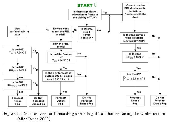
e) Improved Fog Forecasting in the Tallahassee Area. It is very difficult to forecast dense fog in the Tallahassee area. There is similar difficulty in many other parts of the nation. Graduate student Mark Jarvis has studied the occurrence of fog in the Tallahassee area and developed guidance products to assist forecasters. Twenty years of hourly surface observations and seven years of radiosonde data were used to create a fog climatology and determine how the occurrence of fog is related to other meteorological parameters. Results show that dense fog (visibility £ 0.25 miles) forms on warmer than normal nights during the winter season and on cooler than normal nights during the warm season. Many other relationships also were noted. The Florida State University/Oregon State University Planetary Boundary Layer (PBL) model was run on selected dense fog and no fog nights to determine the extent to which the model provides useful forecast guidance.
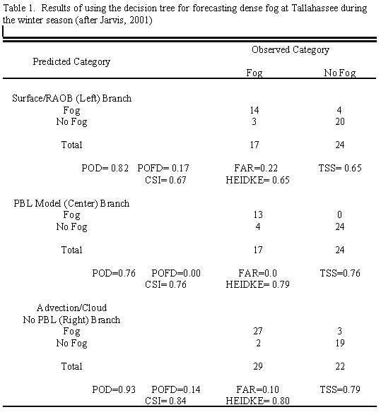
The PBL model output data then were combined with the fog climatology to produce decision trees that will serve as guidance for dense fog forecasting in the area. A separate tree was prepared for each season. Individual meteorological parameters were combined and grouped into three branches: a surface/radiosonde data branch, a PBL model output branch, and an advective fog/cloud/no PBL run branch. The winter season decision tree is shown in Figure 1. The forecasting skill of the combined parameters in each branch was measured using the True Skill Statistic (TSS) and other statistical tools. The PBL model output branches generally were found to produce slightly greater skill scores than the surface/radiosonde branch. The winter season decision tree exhibited the highest overall forecast skill (Table 1), while the warm season decision tree has the lowest forecast skill.
Mr. Jarvis completed and successfully defended his M.S. thesis on this subject during February 2001. A paper is being prepared for the AMS Weather Analysis and Forecasting Conference that will be held in Ft. Lauderdale later this summer.
f) Examine Output from Mesoscale Models. Prof. Ruscher and graduate student John Getz have evaluated models such as the Eta, Florida Division of Forestry MM5, and TLH-NWS MM5. These evaluations aid the interpretation of small scale phenomena such as the sea breeze circulation and frontal boundaries, and forcing of precipitation which would be associated with heavy precipitation and widespread flooding events in the Tallahassee warning area. The relative quickness with which the eta model has changed during the course of this study has made systematic evaluation difficult. Furthermore, John Getz has left FSU and no graduate student replaced him on the project, leaving much of the work unfinished.
g) High Resolution Planetary Boundary Layer Studies. Darrin Lunsford successfully defended his M.S. thesis (June 1999) on the subject of the impact of six-second high-resolution soundings on the initialization and short-term forecasts from a one-dimensional model. Prof. Ruscher supervised Darrin. A demonstrable impact was found at the four subtropical and tropical locations used in the study (Corpus Christi, Tampa Bay, Key West, and Belize City). Forecasts of boundary layer height, low cloud cover, and surface energy balance components (and attendant "sensible weather elements" such as shelter temperature and dew point) were affected, when compared to initializations that utilized only mandatory- and significant-level data. These studies were used in support of research initiatives which are related to forecast situations valid for the entire Gulf of Mexico basin, and will further the work of the use of boundary layer studies at WFO TLH.
In addition, undergraduate student
Geoffrey Stano began his honor's project on fire weather forecasting using the
PBL model. His work will culminate in April 2001 with an honor's thesis and
Macelwane paper (for submission to AMS) on the utility and validity of the model
for this purpose.
h) PBL Parameterizations in the Meso Eta Model. . Prof. Ruscher, undergraduate
Geoffrey Stano, and graduate student Ahsha Tribble have run the one-dimensional
Florida State University/Oregon State University (1D FSU/OSU) planetary boundary
layer (PBL) model in real time. During a 60-day evaluation period in April and
May of 1999, the model was run for all 12 UTC initializations for which model
use was deemed appropriate, for all weather forecast offices (WFO) in Florida,
including Mobile. These appropriate conditions include:
- Lack of strong mesoscale/synoptic forcing at initialization time,
- Lack of middle or high clouds (BKN or better), and
- No precipitation.
For this 60-day evaluation period, we were using the new roughness length values calculated by Ms. Tribble in her M.S. Thesis work. That work demonstrated the importance of proper initialization procedures. ASOS 1-minute observations (such as collected at NWS TLH) were compared to forecasts of shelter temperature for TLH and three other Florida sites. The inclusion of a more realistic roughness length, localized for each site, improved the temperature forecast during a weakly forced case. Boundary layer height, cloud cover, shelter temperature and dew point, and 10 m wind forecasts are among the many variables which are affected by poor initialization, which may include generic values of roughness length as well as other parameters. The model was usable on an average of 42 of the 60 days over the evaluation period.
The acquisition of real-time soil
moisture and advection fields from the Eta model initializations was pursued.
A teletraining seminar for Fall 1999 was prepared on the 1D model and its conversion
to use at the Florida WFOs. We also ran the model for other Gulf Coast locations
with an eye towards expanding its use outside of Florida. This work has broader
implications than just interactions with NWS TLH, but is being pioneered through
cooperation with meteorologists at NWS TLH, particularly Ken Gould, Irv Watson,
and Paul Duval.
i) Transfer of Information. Professor Ruscher conducted teletraining sessions
on December 15, 16, and 17, 1999, entitled "The Practical Atmospheric Boundary
Layer - Importance in Forecasting." This talk was made available to all
NWS Southern Region offices, some CWSUs, and the Eastern and Central region
headquarters. The NWS TLH office hosted the teletraining sessions, and a dry
run was done on 8 December for the TLH forecast staff.
During Fall 1998, Prof. Ruscher was on sabbatical leave at NWS TLH. The purpose of the sabbatical was to begin the organization of a new book on the use of weather data, for academic and general audiences. The book is a work in progress that benefited greatly from the NWS location, where the observations are collected. He worked closely with all individuals at NWS, including supervisory, meteorologist, HMT, and electrical technician staff. Development of the text continues.
Prof. Fuelberg is spending part of his sabbatical leave at NWS TLH during Spring 2001.
j) Modeling the Sea Breeze. Former graduate student Matt Duke and Prof. Fuelberg investigated the role of sea surface temperature (SST) patterns and gradients in the nearby Gulf of Mexico on the development and evolution of the local sea breeze. This constituted Matt's M.S. thesis research. The study was motivated by the National Weather Service Office in Tallahassee running the MM5 model operationally to assist in forecasting the formation and strength of the sea breeze. However, they have used the ETA model's 2 m air temperature field as the MM5's sea surface temperature initialization since no SST data wee available in real time.
Matt selected four cases for intensive study; specifically days with large scale flow from the west, south, east, and light/variable-based on the vector mean wind between 1000-700 mb. A number of MM5 model runs were completed for each case. These simulations utilized the same model settings that are used by NWS TLH in their operational MM5 runs. Three runs for each case were designed to examine the role of land/sea temperature gradients on the evolution and characteristics of the sea breeze. Thus, the same atmospheric (Eta) input was used for each MM5 run, but the SST data were varied such that strong, medium, or negligible gradients were introduced. Two other MM5 runs for each case examined the method used by NWS TLH to incorporate SST data into their operational runs (assigning the lowest level of Eta temperatures to the water).
Results showed that cases with the strongest SST gradients and strongest land-sea temperature gradients produced the most pronounced thermal circulations. On two cases, an existing sea breeze did not occur over the area where the SST gradient was changed the most. Thus, the effects on thermal circulations were minimal. On two other cases, synoptic offshore flow was slowed significantly by the increasingly strong SST gradients. In general, results showed that the MM5 is sensitive to gradients in sea surface temperature. Therefore, for accurate real-time modeling in coastal regions, realistic SST data must be used for model initialization.
Section 2 Summary of University/ National Weather Service Exchanges
a) NWS Class. MIC Paul Duval and SOO Irv Watson conducted a one-hour class each Spring Semester at Florida State University on the operations of the NWS for meteorology majors. Topics included the history of the NWS, job applications, NWS operations, and science and technology used by the NWS. NWS operations included hydrology and forecasting of severe weather, hurricanes, and winter weather. Classes also included the use of new data sources such as gridded model data, lightning, radar, and satellite data. Experts were invited to conduct specialized classes. Invited outside experts have included:
Rusty Pfost - NWS Jackson, MS - Winter Weather
John Hart-SPC Norman, OK-Severe Weather Forecasting
John Feldt - NWS/SERFC, Atlanta, GA - River Forecast Center Operations
Jack Bushong - NWS/SERFC, Atlanta, GA - River Forecast Center Operations
Pat Welsh - NWS Jacksonville, FL - Modeling
Richard Pasch - TPC/NHC, Miami, FL - Hurricane Forecasting
Bernard Meisner-NWS/SRH, Ft. Worth, TX--Modeling
Roger Weldon-NOAA/NESDIS-Use of water vapor imagery for prediction
NWS/TLH personnel included:
Bob Carle - NWS/TLH Hydrology Program
Joel Lanier-NWS/TLH Hydrology Program
Ken Gould - Satellite Program
Alan Baker - CPM Program
Bob Goree - Warning and Coordination Program
Jeff Wallenfang - Radar Operations and Radar Interpretation
Mike Edmonston-Radar Basics
T.J. Turnage-Radar Operations and Radar Interpretation
Ron Block-Putting it all together
Greg Mollere-Coastal Marine Forecasting
Anita Dye-Overview of a National Weather Service Office
Marty Trexler-Overview of WSR-88D Radar
b) NWS/TLH has hosted a number of FSU students for an internship course. The students sign up for several hours of academic credit and then work at the NWS Office, becoming acquainted with the duties of the meteorologist and hydrometeorological technicians.
c) Other NWS/FSU Exchange
NWS personnel served as reviewers
of class projects in Prof. Fuelberg's graduate
mesoscale meteorology class.
Ken Gould presented a one-hour lecture and a one-hour lab on Mesoscale Cloud Climatologies at the COMET University Faculty Satellite Meteorology course in Boulder, CO.
Ken Gould was the Co-lead instructor at several COMET Satellite Mesoscale Meteorology Courses in Boulder, CO.
SOO Irv Watson assisted Mark Laufersweiler (FSU Meteorology Dept) in a one-hour lecture on the use of GARP at FSU.
SOO Irv Watson and Matt Duke (graduate student) attended the MM5 tutorial class in Boulder, CO in anticipation of Matt Duke making major modifications of the NWS/TLH operational MM5 model.
SOO Irv Watson directed Todd Lericos (undergraduate student) on the development of a 9-year lightning climatology for central Florida, Mobile, and Amarillo County Warning Areas (CWAs).
Jeff Fournier has completed a VIL versus severe weather climatology.
The NWS/TLH has obtained HDP X-windows presentation software from Peter Dodge (AOML/HRD) in Miami. Modifications of this software are already underway. Irv Watson and Keith Stellman have summed the HDP data over multi-month periods.
Greg Mollere (NWS meteorologist) worked on a rip-current project. He has requested drowning information from the Florida Division of Vital Statistics for detailed information. It is hoped that this information can be used to develop several case studies showing the type of weather conditions that are favorable for rip tide formation. That research is being continued in follow-on COMET project.
Jeff Fournier and T. J. Turnage have begun graduate studies at FSU.
Prof. Paul Ruscher has spent Fall 1998 working at NWS/TLH. His presence and participation in office discussions has been very rewarding for office personnel. Prof. Ruscher prepared and presented seminars on the Atmospheric Boundary Layer via remote teletraining sessions to many offices in NWS Southern Region.
Prof. Ruscher added two items to the COMET Meted WWW site. These include a link to the history of the U.S. Weather Satellite Program (resource pages), and a link to his CUDOS server (data pages) at http://www.met.fsu.edu/CUDOS.
Ruscher and Watson have had numerous opportunities to work together on various Gempak, GARP, and Unix scripting issues, to help each other streamline flow of routine operational and model data at FSU and NWS TLH.
For much of the funded project and the prior project, the FSU Department of Meteorology hosted the NWS TLH data buoy access WWW site, which at the time of this writing has been transferred to the National Data Buoy Center. That buoy site was a tremendous resource for anyone wanting access to real-time meteorological data offshore (including CMAN stations, as well), and won a NOAA software award for its author, David Faciane.
Section 3.1 Summary of Benefits to Florida State University
The COMET program is very beneficial to FSU. Both Prof. Fuelberg and Prof. Ruscher have strong interests in operational meteorology. COMET provides support for them to focus this interest on local forecasting problems. It allows them to investigate issues that turn out to be great fun! Although COMET faculty are interested in forecasting issues, they do not face the day-to-day challenges of preparing forecasts. They do not have as much time to devote to studying forecast issues. Interaction with NWS personnel provides this needed information. Many FSU students also are interested in operational meteorology. COMET is a mechanism by which graduate and undergraduate students can interact with NWS personnel in ways that foster their educational experiences. COMET also has fostered various types of job opportunities for students at NWS TLH and other offices.
Section 3.2 Summary of Benefits to the National Weather Service
NWS Tallahassee became a full NWSFO
in November 1999, with new staff being hired to assume the added responsibilities.
The job of getting these new forecasters familiar with the local forecast and
climatological conditions has been made easier and faster utilizing studies
completed by the NWS Cooperative Project with the Meteorology Department at
the Florida State University (FSU). These studies have included the Tallahassee
County Warning Area (CWA) severe weather climatology, the lightning, visible
satellite, Hourly Digital Precipitation (HDP), and hail algorithm studies. Our
new forecasters now have a deeper understanding of local weather, so that they
can anticipate developing weather situations, and provide better products and
warnings to the public. Mark Jarvis's fog study that we suggested several years
ago has been anxiously awaited and will be used operationally.
Conversely, we hope that students who are interested in careers in operational
meteorology will always find our door open to them, to help expand and cultivate
their interest. We cannot over emphasize the importance of the decision made
by the National Weather Service and COMET to invest money available for collaborative
purposes. We think that, as a team (FSU Meteorology Department and NWS Tallahassee),
we have made good use of the investment over the years. We look forward to additional
collaborative activities with FSU, similar to the fog study and other recent
completed studies on topics such as lightning, the MM5, and severe weather.
The co-location of NWS/TLH with FSU Meteorology Department is now going forth at full steam. The new building addition is under construction, with completion in Fall 2000. This will begin a new era in relations between FSU and NWS/TLH. The NWS/TLH look forward to this with great anticipation. Real-time construction updates are available on the WWW at http://www.met.fsu.edu/.
Section 4. Presentations and Publications
Camp, J.P., A.I. Watson, and H.E.
Fuelberg, 1998: The diurnal distribution
of lightning over north Florida and its relation to the large-scale flow. Weather
and Forecasting, 13, 729-739.
Connell B., K. Gould, and J. Purdom, 2000: High resolution GOES-8 visible and
infrared cloud frequency composites over northern Florida during the summer
1996-1999. Submitted to Weather and Forecasting.
Duke. J.M., H.E. Fuelberg, and A.I. Watson, 1999: Implementation of SST data into MM5 Runs at NWS TLH. A presentation at the NWS BHM-NASA GHRC Workshop on Numerical Modeling at Huntsville, AL, July 1999.
Duke, J.M., C. Herbster, H.E. Fuelberg, and A.I. Watson, 1999: Utilizing SST data in MM5 runs at NWS TLH. A presentation at the UCAR MM5 workshop held in Boulder, CO, June 1999.
Duke, J.M., and H.E. Fuelberg,
1998: Studies of Sea Surface Temperatures and the Sea Breeze. Presented at the
FL SOO/CITM Workshop held in Tallahassee during May 1998.
Duke, J.M., 1999: The effects of sea surface temperature on numerical simulations
of the sea breeze near Tallahassee, Florida, M.S. thesis, Dept. of Meteorology,
Florida State University, Tallahassee, 64 pp.
Herbster, C.G., A.I. Watson, and R.R. Carle: Mesoscale model simulations, Doppler radar observations and observed rainfall of a land falling tropical storm in the Northeastern Gulf of Mexico. AMS, 12th Conference on Numerical Weather Prediction. 11-16 January 1998, Phoenix, AZ.
Herbster, C.G., and A.I. Watson: Realtime mesoscale modeling in an operational environment. AMS, 12th Conference on Numerical Weather Prediction. 11-16 January 1998, Phoenix, AZ.
Herbster, C.G., K.J. Gould, J.D. Fournier, and A.I. Watson: An idealized mesoscale model simulation under light and variable synoptic flow over the Florida panhandle during the summer. AMS, 2nd Conference on Coastal Atmospheric and Oceanic Prediction and Processes. 11-16 January 1998, Phoenix, AZ.
Jarvis, M.R. 2001: An investigation of forecasting dense fog in the Tallahassee area. M.S. thesis, Dept. of Meteorology, Florida State University, Tallahassee, 70 pp.
Lenning, E., H.E. Fuelberg, and
A.I. Watson, 1998: An evaluation of WSR-88D severe hail algorithms along the
northeastern Gulf Coast. Weather and Forecasting,
13, 1029-1044.
Lericos, T.P., H.E. Fuelberg, and A.I. Watson, 1999: Patterns of Florida convection. A presentation at NWS Melbourne, June 1999.
Lericos, T.P., H.E. Fuelberg, A.I. Watson, and R.L. Holle, 2000: Warm season lightning distributions over the Florida peninsula as related to synoptic patterns, Submitted to Wea. and Forecasting.
Lericos, T.P., H.E. Fuelberg, and A.I. Watson, 2000: A diurnal lightning climatology for Florida. Preprints, Twentieth Conf. Severe Local Storms, Amer. Meteor. Soc., Orlando, 154-157.
Lericos, T.P., H.E. Fuelberg, and A.I. Watson, 1999: Patterns of Florida convection. A presentation at the Kennedy Space Center, June 1999.
Lunsford, T. D., 1999: Impacts of high resolution rawinsonde data on the initialization and forecast of a planetary boundary layer model. M. S. thesis, Dept. of Meteorology, Florida State University, Tallahassee.
Lericos, T.P., H. E. Fuelberg, and A.I. Watson, 1999: Patterns of convection over the southeastern United States. A presentation at the NWS BHM-NASA GHRC Workshop on Numerical Modeling at Huntsville, AL, July 1999.
Ruscher, P. H., 1998: The practical atmospheric boundary layer. NWS Southern Region teletraining, December.
Ruscher, P. H., 1998: The use of GEMPAK and GARP in meteorological case studies in synoptic meteorology at FSU. Presented at the FL SOO/CITM Workshop held in Tallahassee during May 1998.
Ruscher, P. H. and A. Tribble, 1998: Update on the FSU/OSU one-dimensional planetary boundary layer model. Presented at the FL SOO/CITM Workshop held in Tallahassee during May 1998.
Stellman, K., H. Fuelberg, R. Garza, and M. Mullusky, 1999: Utilizing radar data to improve streamflow forecasts. AMS, 29th Radar International Conference on Radar Meteorology, 12-16 July 1999, Montreal, Quebec, Canada.
Stellman, K., H.E. Fuelberg, and A.I. Watson: 1998: QPF Forecasting at FSU and NWS TLH. Presented at the FL SOO/CITM Workshop held in Tallahassee during May 1998.
Stellman, K., H. Fuelberg, and R. Garza, 1999: Utilizing radar data to improve streamflow forecasts. Proceedings of the 1999 Georgia Water Resources Conference, held March 30-31, 1999 at the Univ. of Georgia, Kathryn Hatcher, editor, Institute of Ecology, The University of Georgia, Athens, GA.
Stellman, K.M., H.E. Fuelberg, R. Garza, and M. Mullusky, 2001: An examination of radar- and rain gage-derived mean areal precipitation over Georgia watersheds. Wea. and Forecasting, 16, 133-144.
Tribble, A. N., 1998: The effects of roughness length formulation on boundary layer forecasts. M. S. Thesis, completed, Florida State University.
Watson, A.I., R.R. Carle, and A.D. Baker, 1999: The flood of March 1998 in the Tallahassee Hydrological Service Area - Lessons learned, AMS, 15th Conference on Interactive Information and Processing Systems for Meteorology, Oceanography, and Hydrology and 14th Conference on Hydrology, 10-15 January 1999, Dallas, TX.
Watson, A.I., K.M. Stellman, K.J.
Gould, and P.P. Dodge, 1999: Local applications of the WSR-88D hourly digital
precipitation product at the National Weather Service office in Tallahassee,
Florida. AMS, 29th International Conference on Radar Meteorology, 12-16 July
1999, Montreal, Quebec, Canada.
Watson, A.I., J.P. Camp, and H.E. Fuelberg, 1998: A lightning climatology for
the Tallahassee area. Presented at the FL SOO/CITM Workshop held in Tallahassee
during May 1998.
Watson, A.I.: Developing a local lightning climatology. Presented at the Operational
Applications of Lightning Data Workshop. 30 June-2 July 1998. NWS Southern Region
Headquarters.
Watson, A.I., R.R. Carle, and A.D. Baker: The flood of 7-9 March 1998 in the Tallahassee Hydrological Service Area: Lessons Learned. Abstract submitted to presentation at 15th International Conference on Interactive Information and Processing Systems (IIPS) for Meteorology, Oceanography, and Hydrology, 10-15 January 1999, Dallas TX.
Section 5. Problems Encountered by Florida State University
No problems were encountered.
Problems Encountered by the National Weather Service
No problems were encountered.