(A1)
Executive Summary
1. Project Objectives and Accomplishments
1.1 Introduction
A collaborative study of the utility of tornadic vortex signatures (TVSs) in very short-term prediction was proposed. The archetypal TVS is initially detected aloft, within a mesocyclone, and subsequently "descends" to the ground with the embryonic tornado (Brown et al. 1978). This may foreshadow the near-ground spin-up of the tornado, or first visual sighting of a tornado debris cloud, by as much as a few tens of minutes. Trapp and Davies-Jones (1996) termed this mode I tornadogenesis. Based on a pilot study and work of other researchers, we noticed that some TVSs form somewhat uniformly over a several kilometer vertical depth, or, appear only at the lowest altitudes and then "ascend." These exemplify mode II tornadogenesis, which in theory should occur rapidly, within 5 to 10 min (Trapp and Davies-Jones 1996).
Acknowledging the sensitivities to algorithmic definition and range, we speculated that the guidance provided by a TVS should increase the probability of a successful (verifiable and timely) warning of mode I tornadogenesis. Our challenge was to determine how often, and under what radar-observable conditions, descending TVSs, hence mode I genesis, most likely occur.
The primary objective of this project was to estimate, using a relatively large sample of radar-detected tornadoes, the frequency of "descending" versus "non-descending" TVSs, and then to stratify the descending/non-descending TVSs according to attributes of the tornado and TVS. This embodied the "analysis phase" of the project. Another purpose of the collaborative study was to identify, at one or more of the NWS forecast offices involved in a "proof-of-concept" test, a few specific events whose post-analysis (or otherwise awareness of which) would help shed further light on the tornado warning utility of TVSs.
The principal investigators were as follows: David Andra, NWSFO Norman; Greg Tipton, NWSFO Minneapolis; Jeff Trapp, OU/CIMMS and NSSL; and Irv Watson, NWSFO Tallahassee. Co-investigators included: Dan Effertz, NWSFO Minneapolis; Mike Magsig, NEXRAD OSF; and DeWayne Mitchell, NSSL. OU students Scott Ellis, Brian Fehrn, and Ryan Solomon all served as student research assistants.
Each investigator aided in the compilation of events used to estimate the descending/non-descending TVS frequency. The actual analysis of each event was performed primarily by the OU/CIMMS and NSSL investigators, although NWS investigators Tipton and Effertz (and the student assistants) contributed to this task. Each NWS investigator provided reports and descriptions of TVSs observed during the project. Interpretation and dissemination of project results were responsibilities shared by all investigators. WWW-related activities were supported by Solomon.
1.2 Description of research/development accomplishments
Tornadic vortex signatures of 52 tornadoes were identified and analyzed, then characterized as either "descending" or "non-descending." As mentioned above, this characterization refers to a known tendency of radar-observed tornadic vortices, namely, that of their initial detection aloft, within a mesocyclone, and subsequent descent leading to tornadogenesis. Only 52% of the sampled TVSs descended according to this archetypal model. The remaining 48% were detected first near the ground and grew upward or appeared nearly simultaneously over a several kilometer depth. Analysis techniques used to identify and characterize TVSs are described in the appendix.
The descending/non-descending TVSs were stratified according to attributes of the tornado and TVS. The descending TVSs in our sample were associated with greater pre-tornadic differential velocity, found at mid-altitudes, and were associated with greater tornadogenesis lead time. This result was found to be more or less insensitive to radar range.
|
Pre-tornadic D Vpeak |
Height of peak (ARL) |
No. Volume scans preceding tornadogenesis |
Fujita scale |
|
|
D |
42.8 (±2.37) ms-1 |
3.46 (±0.40) km |
5 (±0.5) |
1 |
|
ND |
31.4 (±1.99) ms-1 |
1.52 (±0.20) km |
3 (±0.6) |
1 |
|
ND (line) |
28.2 (±1.49) ms-1 |
1.0 (±0.02) km |
1 (±0.1) |
1 |
Table 1. Mean values, and standard error about those means, of attributes of 25 descending (D) and 27 non-descending (ND) TVSs and associated tornadoes, and also of 6 non-descending TVSs/tornadoes that formed within convective lines (ND line). Peak "gate-to-gate" differential velocity (see the appendix) is denoted as D Vpeak, and ARL refers to "above radar level."
We classified the parent storm of each tornado as either "line," "cell," or "other" (see Table A1). "Cell" refers to a relatively-isolated, typically-supercellular storm, while "line" is a nearly-continuous line/curve of radar echo (i.e., squall line/bow echo). Hurricane rainband is an example of "other." A contingency table (Table 2) shows that of the seven tornadoes that formed within convective lines, six were associated with non-descending TVSs. In our sample of events, the conditional probability is quite high (0.86) that, given radar-detectable tornadogenesis from a convective line, the TVS will not descend. Moreover, tornadoes that formed within convective lines had non-descending TVSs that provided a mean lead time of approximately 5 min.
On 1 July 1997 in southern Minnesota, several tornadoes formed within a convective line that evolved into a bow echo (as discussed in detail by Howieson and Tipton 1998). From the perspective of WSR-88D KMPX near Minneapolis, the majority of the user-defined TVSs were classified as non-descending. One of us (Tipton) was the KMPX radar operator during this event, and found tornado nowcasting to be particularly vexing, especially along the leading edge of the squall line/bow echo. From this event and ND events in our sample that formed within supercells, it became clear to us that ND does not necessarily imply "non-supercellular" tornadogenesis (see Table 2). In general, all ND events pose a particular challenge to tornado warning decisions and automated detection and diagnosis of tornadic vortices.
|
D |
ND |
|
| Line |
1 (0.14) |
6 (0.86) |
| Cell |
26 (0.67) |
13 (0.33) |
| Other |
0 (0.0) |
6 (1.0) |
Table 2. Contingency table of TVS character (descending, D, versus non-descending, ND) with respect to parent storm type (convective line, cell, or other). Conditional probabilities of TVS character given radar-detectable tornadogenesis within a particular parent storm type are shown in parentheses.
We concluded that an operator-identified TVS used as an adjunct piece of information for tornado warning guidance purposes should further increase the probability of a successful (verifiable and timely) warning, under some circumstances. Convective lines clearly do not represent one of these circumstances and it is possible that other such circumstances exist. Of course, it is inappropriate to base tornado warning decisions only on the existence of a TVS (or on any other single "signature," for that matter). It is appropriate, however, to recognize while making Doppler radar interpretations that an ostensibly large percentage of tornadoes form (within supercells and non-supercells alike) in a manner different than that exemplified by a descending or archetypal TVS.
The framework has been established for WWW-based dissemination of these results and of corresponding TVS interpretation training. The URL is: http://www.nssl.noaa.gov/~trapp/TVSstudy/TVS.html
2. Summary of University/NWS Exchanges
Project objectives and preliminary results were discussed (Trapp) during a severe weather workshop at the Norman NWSFO in March 1997 and later at the Minneapolis NWSFO in August 1997. A meeting between the project investigators and other interested scientists from NSSL and OSF was conducted in November 1997. During this meeting, we compiled and interpreted our results, and then determined the best means to disseminate our findings. In January 1998, work was presented (Trapp) to OSF in support of future plans to construct a new tornado warning guidance document. A formal seminar on this work was given at NSSL in July 1998, and a formal seminar at NCAR is scheduled for September 1998.
3. Presentations and Publications
Two publications resulting directly from this project are as follows:
Trapp, R. J., E. D. Mitchell, G. A. Tipton, D. W. Effertz, A. I. Watson, D. L. Andra, Jr., and M. A. Magsig, 1998: Descending and non-descending tornadic vortex signatures detected by WSR-88Ds. Submitted for publication in Wea. Forecasting.
Trapp, R. J., E. D. Mitchell, G. A. Tipton, D. W. Effertz, A. I. Watson, D. L. Andra, Jr., and M. A. Magsig, 1998: Descending and non-descending tornadic vortex signatures. Preprints, 19th Conf. on Severe Local Storms, Minneapolis, MN, Amer. Meteor. Soc., in press.
A publication resulting indirectly from this project is:
Howieson, E. D., and G. A. Tipton, 1998: Tornadogenesis associated with the 1 July 1997 derecho - A radar perspective. Preprints, 19th Conf. on Severe Local Storms, Minneapolis, MN, Amer. Meteor. Soc., in press.
A presentation on the 1 July 1997 derecho was made (Tipton, Effertz) at the Northern High Convective Workshop in April 1998. Presentations of the latter two papers will be made at the 19th Conference on Severe Local Storms, to be held in Minneapolis, MN, on 14-18 September 1998.
4. Summary of Benefits and Problems Encountered
4.1 University perspective
The university investigator has been sensitized to the multi-faceted tornado warning decision process employed by operational meteorologists. This in itself was quite valuable and educational. Also, discussions with the NWS investigators have revealed perspective follow-on projects. For example, awareness of the challenges of tornado warning and detection in convective lines was raised as a result of NWS forecaster interaction. Finally and perhaps most importantly, NWS collaboration helped clarify and otherwise provided the steps required to make a theoretical study useful to the operational community.
4.2 NWS perspective
This project has allowed NWS forecasters to develop an improved understanding of tornadogenesis and recognize that TVS evolution often differs from the archetypal descending conceptual model. Recognition of this fact is operationally significant since the non-descending TVS offers less lead time to tornadogenesis. Further, previous NWS training material has presented only one mode of TVS evolution (descending). This study may be used as a foundation for expanding NWS training as it relates to TVS interpretation and application. Finally, by participating in this study, the NWS principal investigators have gained applied research experience and forged relationships with those in the academic and research communities. The free exchange of ideas between the research and operational communities should continue and must be nurtured. A more universally accepted research product and enhanced operations at the WFO are only a few results of this process.
A specific way of how the interaction positively impacted MSP operations, for example, was that radar operators began to look for and at times expect tornadogenesis in the lower levels of the atmosphere (below 5000 feet). This was especially true with detecting tornadogenesis along the leading edge of squall lines or bow echoes. Another way was that most radar operators began to take public and spotter reports of funnel clouds and possible tornadoes beyond 50 nm more seriously. It became plausible to the forecasters that a low level spin up may not be seen in the velocity data at greater than 50 nm where the radar beam is above 5000 ft. Forecasters would try harder to prove or disprove the report using conceptual models, radar data, and/or trying to confirm the report from a separate source. Another result of the collaboration was a couple of related research projects (listed above) and a number of ideas for future operational research projects.
References
Brown, R. A., L. R. Lemon, and D. W. Burgess, 1978: Tornado detection by pulsed Doppler radar. Mon. Wea. Rev., 106, 29-39.
Howieson, E. D., and G. A. Tipton, 1998: Tornadogenesis associated with the 1 July 1997 derecho - A radar perspective. Preprints, 19th Conf. on Severe Local Storms, Minneapolis, MN, Amer. Meteor. Soc., xxx-xxx.
Mitchell, E. D. S. V. Vasiloff, G. J. Stumpf, A. Witt, M. D. Eilts, J. T. Johnson, and K. W. Thomas, 1998: The National Severe Storms Laboratory tornado detection algorithm. Wea. Forecasting, xx, xxx-xxx.
Trapp, R. J., and R. Davies-Jones, 1997: Tornadogenesis with and without a dynamic pipe effect. J. Atmos. Sci., 54, 113-133.
Witt, A., M. D. Eilts, G. J. Stumpf, E. D. Mitchell, J. T. Johnson, and K. W. Thomas, 1998: Evaluating the performance of the WSR-88D severe storm detection algorithms. Wea. Forecasting, xx, xxx-xxx.
Wood, V. T., and R. A. Brown, 1997: Effects of radar sampling on single-Doppler velocity signatures of mesocyclones and tornadoes. Wea. Forecasting, 12, 928-938
Appendix. TVS identification and characterization
Tornado events were selected based on existence of WSR-88D Level II (base reflectivity, velocity, and spectrum width) data and of damage verification data (as provided, e.g., through Storm Data ). Specifically, we sampled the population of all tornadoes detected by WSR-88Ds with Level II data recorders, within a range of 150 km. The resultant, geographically-diverse data set, comprised of 52 events, is described in Table A1. Individual events vary from southern Great Plains supercell tornadoes to landfallen tropical cyclone-spawned tornadoes, and were observed at radar ranges between 23 km and 137 km. Strictly speaking, this sample was not randomly-selected, although the tornadoes were not chosen preferentially other than to achieve geographic diversity as a proxy for different environmental conditions.
Verification data were at times problematic, forcing the need for modification. As discussed by Witt et al. (1998), tornado formation times reported in Storm Data may be in error by perhaps one hour, owing to a variety of non-meteorological reasons. Damage path locations are less likely to contain gross deficiencies. Accordingly, the damage report of each event in Table 1 was compared with the radar data to confirm that a mesocyclone or TVS was at least in the vicinity of the tornado damage path begin point, at the reported tornado formation time. When such confirmation was not possible, formation time was equated to the beginning time of the radar volume scan within which the storm's (i.e., mesocyclone or TVS) position and damage path beginning point were approximately collocated.
The TVS associated with each tornado was manually-identified. Though time-intensive, this manual approach prevented the otherwise possibility of erroneous automated identification owing to, for example, improperly dealiased velocity gates by a dealiasing algorithm. Simple TVS identification criteria were used at each elevation angle, within each of several volume scans per event examined: (i) three velocity gate shear segments, adjacent in azimuth and constant in range, with differential velocity (D V) = 15 ms-1; and (ii) time and height continuity. These are based loosely on the NSSL TDA (see Mitchell et al. 1998, their Figs. 1-2). When the criteria were met, the maximum differential velocity D Vmax and its attributes of azimuth, range, time, and altitude above radar level (ARL), were recorded for each elevation angle, within each radar volume scan. Note that our criteria allow the designation of a TVS in absence of a mesocyclone, and at a single elevation angle, above and below which need not contain a rotational velocity signature. The reader also should note that the differential velocity threshold of 15 ms-1 is significantly lower than that encountered by users of the current WSR-88D TVS algorithm, and that D V = 15 ms-1 at some altitude ARL does not necessarily imply impending tornado formation. Our analysis benefited from a priori knowledge of tornado location and formation time.
An objective means of characterizing a TVS as either descending (D) or non-descending (ND) was employed. The idealized, empirically-determined models on which this classification scheme was based are shown in Fig. A1. Briefly, descending TVSs (and associated mode I tornadogenesis) tend to exhibit distinct maxima in differential velocity aloft (> 2-7 km) at least one volume scan prior to tornadogenesis. In vertical profiles constructed of the maximum D V at each elevation angle, this is shown by an increase with height of D V. Over time, D V at lower levels increases relative to that aloft in prior volume scans. In some events, the peak D V at tornadogenesis is found at the lowest tilt, while in others, it remains aloft even though D V increases substantially at lower levels. Non-descending TVSs often begin as shallow (depth < 2-3 km) features with peak D V values at heights of 1 km or less (as allowed by range). They may build upward in time, but the peak D V typically remains at heights < 2 km or so. Alternatively, these TVSs may begin with weak to moderate D V that is relatively uniform with height. Subsequent intensification occurs uniformly with height.
Consider
where zpeak is the altitude (ARL) of the peak differential velocity D Vpeak within a volume scan, and zlow is the altitude of the maximum differential velocity D Vlow at the lowest elevation angle, within the same volume scan, where the TVS criteria are met (see Fig. A1a). Equation A1 approximates the slope of the differential velocity curve between the ground and the altitude of the peak. If zpeak occurs at the base (0.5°) elevation angle, or, if the TVS criteria are met only at a single elevation angle, then we assign
(A2)
which assumes a linear decrease toward the ground in differential velocity.
Two empirically-determined parameters, optimized to fit a subjective classification, were used to discriminate D from ND events. If
S = 2.25 m s-1 km-1, and zpeak = 3.0 km (A3)
in at least one volume scan preceding that of tornadogenesis, the TVS was classified as descending. Otherwise, the TVS was classified as non-descending. Note that we required (A3) in one volume scan only, in order to account for differential velocity changes owing to the non-physical effects of radar sampling (Wood and Brown 1997).
| Date | Time (UTC) | Radar | F-Scale | Azimuth (degrees) | Range (km) | TVS character | Parent storm type |
| 5/11/92 | 1825 | KOUN | 0 | 141.9 | 59.8 | D | C |
| 5/11/92 | 1850 | KOUN | 2 | 150.2 | 92.0 | D | C |
| 5/11/92 | 1910 | KOUN | 1 | 114.1 | 101.6 | D | C |
| 5/11/92 | 2020 | KOUN | 1 | 126.7 | 104.7 | ND | C |
| 4/26/93 | 1353 | KLWX | 1 | 269.0 | 54.0 | ND | L |
| 5/7/93 | 0023 | KDDC | 2 | 85.4 | 89.9 | D | C |
| 11/16/93 | 1310 | KHGX | 0 | 259.8 | 36.8 | ND | C |
| 11/16/93 | 1520 | KHGX | 0 | 8.3 | 59.8 | ND | C |
| 11/16/93 | 1549 | KHGX | 1 | 308.4 | 44.6 | ND | C |
| 11/16/93 | 1627 | KHGX | 0 | 341.4 | 48.9 | ND | C |
| 11/16/93 | 1730 | KHGX | 0 | 10.8 | 100.3 | ND | C |
| 11/16/93 | 1819 | KHGX | 1 | 18.5 | 33.1 | ND | C |
| 4/26/94 | 2303 | KNQA | 0 | 190.3 | 48.8 | D | C |
| 4/26/94 | 0005 | KNQA | 0 | 181.4 | 55.0 | D | C |
| 4/30/94 | 0100 | KLWX | 1 | 324.3 | 92.0 | ND | C |
| 4/30/94 | 0110 | KLWX | 2 | 345.9 | 91.2 | D | C |
| 5/6/94 | 0015 | KINX | 1 | 298.8 | 135.1 | D | C |
| 5/28/94 | 0104 | KAMA | 1 | 49.2 | 107.8 | D | C |
| 6/9/94 | 1810 | KNQA | 1 | 180.5 | 23.0 | ND | L |
| 11/27/94 | 2000 | KNQA | 1 | 347.7 | 24.8 | D | C |
| 11/27/94 | 2030 | KNQA | 3 | 20.7 | 36.5 | ND | C |
| 11/27/94 | 2115 | KNQA | 3 | 201.0 | 48.3 | D | C |
| 4/19/95 | 0204 | KFWS | 1 | 62.6 | 34.7 | ND | L |
| 5/7/95 | 2053 | KFWS | 3 | 331.4 | 99.5 | D | C |
| 5/16/95 | 2316 | KDDC | 2 | 278.8 | 86.5 | D | C |
| 5/16/95 | 0139 | KDDC | 3 | 32.0 | 48.2 | ND | C |
| 5/18/95 | 1712 | KLSX | 2 | 172.7 | 54.8 | D | C |
| 5/28/95 | 0055 | KDMX | 4 | 216.4 | 101.3 | D | C |
| 6/2/95 | 2335 | KLBB | 3 | 318.8 | 137.2 | D | C |
| 6/2/95 | 0102 | KLBB | 2 | 335.3 | 106.5 | D | C |
| 6/22/95 | 2240 | KPUX | 1 | 328.0 | 67.5 | D | C |
| 7/21/95 | 2331 | KMPX | 1 | 298.6 | 59.5 | D | C |
| 7/21/95 | 2350 | KMPX | 0 | 258.9 | 77.3 | D | C |
| 7/21/95 | 0004 | KMPX | 2 | 345.0 | 88.0 | D | C |
| 7/21/95 | 0035 | KMPX | 1 | 352.4 | 27.0 | D | C |
| 7/21/95 | 0050 | KMPX | 0 | 251.2 | 62.0 | D | C |
| 7/21/95 | 0058 | KMPX | 1 | 16.9 | 85.0 | D | C |
| 7/21/95 | 0110 | KMPX | 0 | 4.3 | 86.5 | D | C |
| 7/21/95 | 0121 | KMPX | 1 | 234.3 | 50.3 | ND | C |
| 7/21/95 | 0228 | KMPX | 1 | 186.1 | 24.5 | ND | C |
| 10/4/95 | 1659 | KEVX | 2 | 283.1 | 57.3 | D | C |
| 10/4/95 | 1745 | KEVX | 1 | 352.1 | 15.4 | ND | C |
| 10/4/95 | 1832 | KEVX | 0 | 102.5 | 63.5 | ND | O |
| 11/11/95 | 0910 | KJAN | 3 | 301.6 | 41.5 | ND | L |
| 11/11/95 | 1040 | KJAN | 3 | 153.9 | 72.8 | ND | L |
| 7/12/96 | 0209 | KAKQ | 1 | 99.3 | 42.1 | ND | O |
| 7/12/96 | 0245 | KAKQ | 1 | 64.5 | 56.4 | ND | O |
| 7/12/96 | 0302 | KAKQ | 0 | 67.2 | 66.7 | ND | O |
| 7/12/96 | 0320 | KAKQ | 0 | 40.6 | 64.6 | ND | O |
| 7/12/96 | 0443 | KAKQ | 0 | 47.0 | 108.8 | ND | O |
| 7/2/97 | 0052 | KMPX | 1 | 10.4 | 59.5 | ND | L |
| 7/2/97 | 0115 | KMPX | 1 | 43.3 | 60.3 | D | L |
Table A1. Description of data set. "Time," "Azimuth," and "Range," all refer to tornado formation, with respect to the radar listed in the third column. "F-scale" is the estimate of maximum tornado intensity based on the Fujita-scale. Designator "D" (ND) refers to descending (non-descending) TVS, and "C," "L," and "O," refer to parent storm type of cell, convective line, or other, respectively.
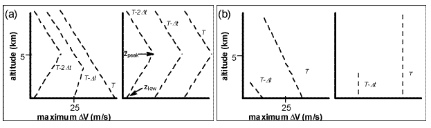
FIG. A1. Vertical profiles of the maximum, gate-to-gate
differential velocity, D V (ms-1), at a few times (corresponding to radar volume scan times) during tornado development,
for the idealized, empirically-determined models on which the (a) descending and (b) non-descending classification
is based. The altitude zpeak of the peak differential velocity D Vpeak within a volume scan, and altitude zlow
of the differential velocity D Vlow at the lowest elevation angle, within the same volume scan, are indicated in
(a).