SUNY-Albany: "Meso-Eta
model simulations of a troublesome heavy rainfall event"
Final Report
1. Project Summary
During 15-17 November 1987 exceptionally heavy (and unforecast) rains fell over the lower Mississippi River Valley
(rainfall totals in Louisiana exceeded 50 cm) in association with the passage of two very large mesoscale convective
complexes (MCC). Each MCC was associated with a migratory upper-tropospheric potential vorticity (PV) anomaly and
associated jet streak that could be readily tracked by means of dynamic tropopause (DT) analyses. Noteworthy aspects
of this case, in addition to the heavy rains, included the existence of multiple long-lived wake-low troughs (WLTS)
and large-amplitude inertia-gravity waves (IGWs). Surface pressure perturbations associated with these WLTs and
IGWs reached ~10 hPa. Widespread rain-cooled air contributed, in part, to the formation of an extensive stable
layer in the lower troposphere that served as a wave duct for WLT and IGW amplification and propagation. The details
of earlier findings for the 15-17 November 1987 case are contained in Bracken (1995) and Corfidi et al. (1990).
In an attempt to improve on the quantitative precipitation
forecast (QPF) from the then operational version of the Regional Analysis and Forecast System (RAFS) we conducted
NCEP meso-Eta (29 km version) model reruns of the 15-17 November 1987 case as part of a COMET Partners Proposal
(Meso-Eta Model Simulations of a Troublesome Heavy Rainfall Event; COMET Partners Project #UCAR S9787015 covering
the period 3/l/97 - 3/l/98). Specifically, the Betts-Miller (BM) (Betts and Miller 1986) and Kain-Fritsch (KF)
(Kain and Fritsch 1990; Stensrud and Fritsch (1993) convective parameterization schemes were tested to determine
their impact on precipitation location and amount in the 29 km version of the meso-Eta model (hereafter MEM). The
results from this COMET investigation can be summarized as follows:
a) The 29 km MEM using the KF convective parameterization
scheme was better able to predict the timing and precipitation structure than the control run using the BM scheme.
The KF MEM forecast correctly concentrated the axis of heavy convective rains in a much narrower and heavier band
than predicted by the control run using the BM scheme. The KF run produced a rainfall maximum of 230 mm over southern
Arkansas whereas the BM control run forecast a 130 mm rainfall maximum over southern Louisiana. These QPF differences
are illustrated in Figs. 1 and 2 which show 24 h accumulated precipitation from the 12-36 h forecast periods of
the MEM using the BM and KF schemes, respectively. Both model runs were initialized 1200 UTC 15 November 1987.
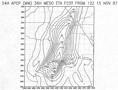
Figure 1
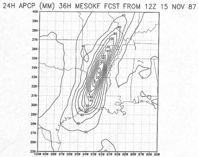
Figure 2
b) Both the KF and BM MEM runs produced a superior
QPF than the operational RAFS did in 1987. However, neither model: (1) developed the strong observed mesoscale
boundary across Louisiana. (2) correctly predicted where the axis of heaviest rain would fall, and (3) simulated
the observed strong wake troughs and lows. The low-level boundary that developed over Louisiana appeared to be
critically important in focusing convection, heavy rainfall, and severe storm development.
c) Small-scale cyclones (~100 km) appeared to form
as upper-level potential vorticity (PV) anomalies associated with distinct jet streaks approached regions of enhanced
low-level cyclonic vorticity in regions of relatively low static stability.
Betts, A. K., and M. J. Miller, 1986: A new convective
adjustment scheme. Part II: Single column tests using GATE wave, BOMEX, ATEX and arctic air-mass data sets. Quar.
J. Roy. Meteor. Soc., 112, 693-709.
Bracken, W. E, 1995: The severe weather outbreak
of 15-17 November 1987: A Multiscale case study. Master of Science Thesis. State University of New York at Albany,
276 pp.
Corfidi, S. F., N. W. Junker, and F. H. Glass, 1990:
The Louisiana/Mississippi flash flood and severe weather outbreak of 15-16 November 1987. Preprints, 16th American
Meteorological Society Conference on Severe Local Storms, Alberta, Canada, 627-633.
Kain, J. S., and J. M. Fritsch, 1990: A one-dimensional
entraining/detraining plume model and its application in convective parameterization. J. Atmos. Sci., 47. 2784-2802.
Stensrud, D. J., and J. M. Fritsch, 1993: Mesoscale
convective systems in weakly forced large- scale environments. Part I: Observations. Mon. Wea. Rev., 121, 3326-3344.
2. Related work by the University
One of us (Bosart) has had informal talks with staff
members of the NWSFO-Albany and the SPC-OUN on the importance of closely monitoring large rain-cooled regions for
potential wake low/trough development and large-amplitude inertia-gravity wave (IGW) development when deep convection
is embedded in the general rain area. Real-time large-amplitude IGW forecasting attempts have also been made by
Anton Seimon. These informal forecasts have been communicated over the Internet to various people (including Louis
Uccellini of OM) as convective events with widespread precipitation and widespread rain-cooled air have unfolded.
Future seminars are planned and results will be
presented at the next Weather Analysis and Forecasting and Numerical Weather Prediction Conferences.
3. Related work by
the NWS
None
4. Benefits to University
The benefit to the University continues to be the
opportunity to keep abreast of state-of-the-art developments of the meso-Eta model as run at NCEP. For example,
current NCEP plans are to run a 16-km early meso-Eta model four times daily beginning in early 1999, assuming the
new class VIII machine is obtained this fall. In December 1997 two of us (Bracken and Bosart) journeyed to NCEP
to meet with DiMego, Junker and Rogers. This meeting proved to be a very valuable in revealing important details
of various physics packages (e.g., the Kain-Fritsch (KF) cumulus parameterization scheme) used in the meso-Eta
model. This information has been passed along to SUNY/Albany students and faculty through informal talks and more
formally in the classroom. In the future NCEP people will visit SUNY/Albany to present updated results from the
special meso-Eta model runs.
5. Benefits to the NWS office
The main benefit to NCEP from this work was the
opportunity to assess and diagnose the performance of the operational BM and the experimental KF scheme in the
MEM for an extreme rain event. The performance of the operational MEM with the BM scheme made it clear to NCEP
that the current operational MEM is incapable of resolving the fine scale structures observed, due to insufficient
horizontal resolution, inadequate initialization of relevant surface/boundary layer features, and deficiencies
in the model physics. The marked improvement in the precipitation forecast obtained from the KF scheme shows much
promise. However, the results from the 29-km MEM BM and KF runs of this case show that NCEP needs to put considerable
work into 1) successfully forming and maintaining mesoscale structures (e.g., cool-pools), and 2) improving the
operational 3-d variational analysis (3DVAR) to analyze observed mesoscale features at and near the surface.
6. Publications
None yet. It is expected that these will follow
after a further numerical experiment (if funded) which will specifically include a rain-cooled stable layer in
the KF scheme.