Section 1. Project Objectives and Accomplishments
1.1 Specific objectives
1) Analyze spatial patterns in DMCS occurrences in the North-Central Great Plains and find corridors of favored development annually, seasonally, and monthly for the period 1986-1995.
2) Develop a regionalized pattern-recognition/diagnosis technique for recognizing conditions favorable for derecho development and propagation.
3) To create an understanding of the MCS and DMCS environment in order to simplify the forecast/nowcast process.
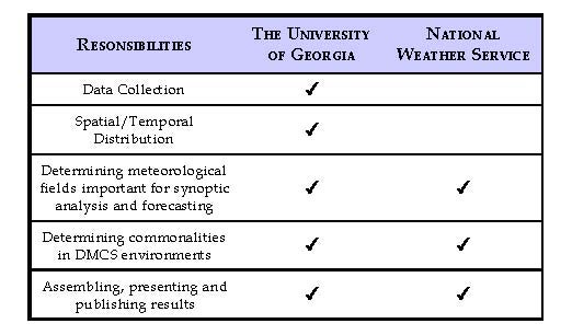
Table 1: Division of responsibilities
Mace Bentley, a Ph.D. student at the University of Georgia, conducted most of the research, which was included in his dissertation. Mr. Bentley worked closely with Steve Byrd by means of telephone, fax and electronic communications. Mr. Bentley also spent a week at the Omaha/Valley National Weather Service Office working closely with Steve and other forecasters on the synoptic analysis. The primary responsibility of Dr. Mote has been to oversee the project, provide research facilities for Mr. Bentley and to assist in the writing and organization of publications and conference presentations. All three participants attended the 19th Conference on Severe Local Storms in Minneapolis during September of 1998.
1.2 Accomplishments/Findings
1.2.1 Spatial/Temporal Analysis
When characterizing events by location and orientation, four corridors of derecho activity were identified by looking at individual wind damage tracks. To qualify as a corridor, there must be at least four events that are in the same region and have a similar track orientation. The southeastward moving northern tier events are oriented parallel to the axis of northwest flow severe weather outbreaks. This was the prominent region of derecho occurrence during the Johns and Hirt (1987) investigation. DMCSs in this corridor appear to be most prominent in July and August, with 79% of the events occurring at this time. This is also the most active corridor with 31% of all summer derechos being southeastward moving northern tier events. These derechos are also characterized by rather long durations (on average, 11 hours) and tracks. They seem to favor late evening or overnight development, more characteristic of nocturnal mesoscale convective complexes (MCCs). The next most active region is located in the Central and Southern Great Plains. These southward burst type DMCSs encompass 24% of all summer events. Southward burst DMCSs occurred throughout the summer months and produced the longest duration derechos of the season (on average 12.2 hours). They also appear to favor initiating during the late morning to afternoon hours, significantly different from other summer DMCSs.
Northeastward moving Great Plains events, primarily developing off the Front Range of the Rocky Mountains, form another prominent corridor in the north-central Great Plains. 20% of summer DMCSs were Plains events that, contrary to previous findings, move northeastward instead of southerly. Great Plains DMCSs occurred in the early summer with 83% developing in either June or July. Overall, these derechos were of slightly shorter duration (on average 8.8 hours) than derechos in other summer corridors. The DMCSs appear, however, to be closely linked to nocturnal MCCs, since they tend to form in the overnight hours.
1.2.2 Operational recognition of derecho conducive environments.
Distinct synoptic environments produce derechos in the North-Central Plains. The subsequent location and movement of these events also appears to be primarily dependent upon the synoptic environment. Recognition of key atmospheric features is essential in accurately predicting the onset and movement of DMCSs.
Johns and Hirt (1987) developed a derecho checklist to aid meteorologists in identifying important elements in the synoptic environment conducive to DMCS formation. This decision tree would have proved quite useful for predicting southeastward moving northern tier events in this study. These events, which emanate from the northwest flow (NWF) axis, satisfied most elements in the checklist. However, 40% of the DMCSs identified as affecting the Northern Plains were not located along the NWF A1 axis. In fact, they were northeastward moving Central Plains events. These results suggest an update investigation could further assist meteorologists in assessing environments conducive to derecho formation in the Northern Plains.
Initial diagnosis of a potential DMCS environment begins by determining whether severe convection can be initiated. A high degree of convective instability has been well documented as a common feature of DMCS environments. The average lifted index and CAPE for events in this investigation were -4°C and 2609 J kg-1 respectively, with greater instability found downstream. Moderate low-level wind shear (10-18 m s-1) was also seen in the initiation hodographs for DMCS events. These two ingredients are both critical for DMCS formation. If the environment contains moderate shear and is convectively unstable, then the presence of a localized forcing mechanism can act to initiate and organize convection.
During the summer months, shortwave troughs moving through the polar front often provide the localized forcing necessary to initiate and organize convection. Typically, convective instability is high under the ridge. The approaching shortwave, through the formation of a surface low pressure center, can circulate a portion of this convectively unstable moist layer out from under the capping inversion. Nearly 85% of the DMCSs in this investigation formed on the north side of a surface low pressure center along the "nose" of a 2e gradient. Evidence suggests, surface low pressure formation along a quasi-stationary front is essential in promoting underrunning and subsequent severe convection in North-Central Plains warm season DMCS environments.
In order for derechos to occur, the synoptic environment must support a convective system capable of producing widespread wind damage along a major axis of at least 400 km. To determine this capability and predict DMCS movement, an examination of the low to mid-level wind field is necessary. Calculation of the 700 to 500 hPa layer averaged wind field has proven to be a useful predictor of DMCS movement. In this investigation, the DMCSs deviated slightly to the right of the flow as they traveled away from the initiation region. This characteristic is partly due to the weakening of the capping inversion along the DMCS track. The systems appear to build southward toward the quasi-stationary boundary as the lift required to break the capping inversion decreases. Another key element present in derecho environments is the nearly parallel orientation of the quasi-stationary boundary to the mid-level flow. DMCSs typically move along the surface boundary in the direction of the mid-level layer averaged flow. This is likely due to the importance of the relationship between the convectively-induced cold pool and vertical shear.
Cold pool strength is related to three main elements present in the synoptic environment: large values of CAPE, the moisture content of the low to mid-troposphere, and moderate to strong low-level shear. However, recent investigations into observed shear profiles associated with long-lived bow echoes yield contradicting results. In this investigation, a weak to moderate shear profile (9 to 14 m s-1) was commonly observed in hodographs taken near North-Central Plains DMCSs. This supports recent findings that other mechanisms in the DMCS environment might assist in balancing cold pool circulation and lead to upright convection. The component of environmental shear perpendicular to the line orientation (line-normal shear) is the most critical for controlling MCS structure and evolution. Once DMCS movement is estimated from the layer averaged winds, diagnosis of the downstream environment should be made. Increasing convective instability and vertical shear depth was evident in along-track soundings. Line-normal shear throughout 6 km with unidirectional shear through the upper-levels, visible in the hodographs, appears to be a conducive wind profile in the derecho environment.
Cross-sections along the DMCS track, estimated by utilizing the 700 to 500 hPa layer averaged winds, were also found to be useful in assessing the potential of the synoptic environment to support DMCSs. A tight vertical theta-e gradient, decreasing with height, was evident in the majority of events. Drier mid-level air overlying moist surface air leads to strong convective-scale downdrafts and has been identified in other bow echo and/or derecho environments. The strong convective-scale downdrafts and mesohigh formation common in DMCS environments produces a gust front that moves faster than the mean flow. In this investigation, the DMCSs moved an average of more than 30% faster than the 700 to 500 hPa layer averaged wind speeds. This high translation speed maximizes leading edge convergence on the downshear side of the DMCS. Likewise, convective forcing in this area produces a forward propagation of the system. In environments containing deeper layer moisture, convective forcing along the gust front is much weaker and low-level convergence occurs upshear, leading to a quasi-stationary MCS.
Diagnosis of the strength and depth of the along track WAA is also aided by examining cross-sections. The quasi-stationary boundary provides a thermal gradient across which low-level WAA developed in the majority of the events. The WAA is a source of upward vertical motion realizing the potential energy of the convectively unstable air along and south of the boundary.
Unidirectional, line-normal flow occurs throughout the mid and upper-levels of the DMCS environment. Temperatures at 500 hPa are somewhat cooler then average, representative of a severe thunderstorm environment. The composite hodographs and idealized sketches of the synoptic-scale situations favorable for DMCSs emanating from specific corridors should assist meteorologists in determining when the mid to upper-level flow is in a favorable alignment.
Section 2. Summary of University/NWS Exchanges
The primary information exchanges occurred:
First, the production of a derecho forecasting primer that summarizes in an operational manner the significant findings from the investigation. This document is primarily intended to assist forecasters in utilizing available technology to assess environments conducive to MCS and subsequent derecho formation.
Secondly, numerous exchanges of information and data also took place when Mr. Bentley traveled to the NWSFO to work with Mr. Byrd. A better understanding of the role and needs of operational meteorologists was gained by Mr. Bentley to help in the creation of products that will support operations. While working at the NWSFO, Mr. Bentley was able to discuss forecasting methods and techniques with many forecasters at the office including: Steve Byrd, SOO, Brian Smith, WCM, Rick Chermok, lead forecaster, and Dave Skerritt and Cathy Zapotocny, forecasters. Along with discussions concerning severe weather operations and several recent derecho events, data was exchanged between Mr. Byrd and Mr. Bentley. Mr. Byrd had archived most of the observation, model, and radar data from recent derecho/bow echo events. He made this data available to Mr. Bentley in order to assist in the construction and verification of several of the findings regarding the role of surface features in the initiation of DMCSs. This also allowed Mr. Bentley to complete the analysis utilizing products that meteorologists at the NWSFO tend to use to assess the severe weather potential of the environment. These products/meteorological fields include: theta-e analysis, moisture transport, and layer-averaged RH and winds. Mr. Byrd also provided several issues of the NWS newsletter he created concerning severe weather forecasting techniques. These newsletters were invaluable for providing an important review of the literature concerning currently accepted theories and techniques surrounding severe convective storms.
Mr. Bentley also provided for Mr. Byrd and the staff at the NWSFO, his perspective on derechos and the results of the recently completed 10-year climatology of derecho events. He also brought hard copies of the maps generated for the 19 derecho events analyzed for the investigation. These maps were created using GEMPAK 5.4 and the UCAR/NCEP reanalysis dataset. The utility of this dataset in producing synoptic climatologies of significant climatic events was illustrated in this investigation. Throughout the investigation, this dataset was found to be superior to using gridded radiosonde observations for re-constructing the synoptic environment surrounding derecho events.
Section 3. Publications and Presentations
Bentley, M. L., 1999: A synoptic climatology of derecho producing mesoscale convective systems in the Eastern United States, 1986-1995. Ph.D. dissertation, The University of Georgia, 133 pages.
Bentley, M. L., T. L. Mote, and S. F. Byrd, 1999: Northern Plains Derecho Producing Mesoscale Convective Systems (DMCSs): A Forecasting Primer. National Weather Service Central Region Training Note, 19 pages, forthcoming.
Bentley, M. L. and T. L. Mote, 1998: A synoptic climatology of derecho producing mesoscale convective systems 1986 - 1995, Part I: temporal and spatial distribution. The Bulletin of the American Meteorological Society, 79, 11, 2527-2540.
Bentley, M. L., T. L. Mote, and S. F. Byrd, 1998: Synoptic-scale conditions associated with derecho producing mesoscale convective systems in the Northern Plains. Draft complete.
Bentley, M. L., T. L. Mote, and S. F. Byrd, 1998: A synoptic climatology of derecho producing mesoscale convective systems: 1986 -1995. Preprints, 19th Conference on Severe Local Storms, Bloomington, MN, American Meteorological Society, 5-8.
Bentley, M. L. and T. L. Mote, 1998: A climatology of derechos: 1986 - 1995. Abstracts, Annual meeting of The Association of American Geographers, Boston, MA.
Section 4. Summary of Benefits and Problems Encountered
4.1 University's perspective
Overall, this investigation was a great success. As shown, several significant findings were found in examining the derecho environment that should further our understanding of these events. These results will also likely serve the operational community well and should be used as an example of how the research community can provide analysis tools and expertise to directly assist operational meteorologists.
The use of modern technologies such as electronic mail, ftp, and telnet, along with fax and phone transmittance also made this project not only possible, but successful even though the researchers were hundreds of miles apart. Future collaborations between NWSFOs and Universities not located in the same region should still be considered. Although the week spent at the NWSFO was the most productive for Mr. Bentley, communication was not severly hampered by the distance between the University and the forecast office.
A large portion of Mr. Bentley's Ph.D. dissertation was also completed while conducting the investigation. The invaluable experiences gained by Mr. Bentley while working with Mr. Byrd and the staff of the Omaha/Valley NWSFO have greatly facilitated the analysis and provided insights into the derecho environment that would have likely gone unnoticed. The operational experience of Mr. Byrd and his understanding of synoptic and mesoscale processes assisted Mr. Bentley in formulating the write-up of results for both this investigation and the dissertation.
Many of the findings from this investigation will also be incorporated into classroom instruction. Mr. Bentley already includes material highlighting the distribution of derechos in his Weather and Climate classes. Dr. Mote also includes derecho related materials in his classes: synoptic meteorology and satellite climatology. Significant findings from this investigation will be incorporated in this instruction and also utilized in World Wide Web based laboratory instruction.
The only problems encountered while working on the analyses was due to either workload coordination or cross-platform data problems. Since this was an active severe weather season, especially during the major part of the investigation, it was difficult at times to coordinate and meet deadlines during the analysis between the University and NWSFO. This is completely understandable and expected, but sometimes posed additional challenged nonetheless. The major cross-platform problems encompassed the use of data and in the write-up of results. The NWS utilizes HP workstation running HPUX while The University of Georgia's Climatology Research Laboratory contains Sun workstations running Solaris 2.x. This caused some minor problems in data transferring, but none that couldn't be remedied. Also, final graphic generation for publications and presentations was completed by Mr. Bentley using several software packages residing at the University. This also created editorial and revision problems at times due to the differences in software between the NWS and The University of Georgia.
4.2 NWS perspective
During the period of investigation and research both NWS and the academic community gained from this joint venture. Results of the findings for northeastward moving derecho types was found with the occurrence of a significant long path derecho on May 15, 1998. This derecho case was presented at the High Plains Severe Weather Seminar at Hastings, Nebraska in August 1998. This talked sparked an expanding interaction with the Storm Prediction Center, as SOO, Bob Johns was present at the seminar. Mr. Johns has encouraged further investigation into the findings and the development of the database for the study.
In order to test the results beyond NWSFO Omaha planned for this summer utilizing AWIPS procedures and PCGRIDDS scripts, the Derecho Primer has been submitted to Central Region Headquarters (CRH) for review and possible publication as a Technical Training Note . In conjunction with the works of several other authors the derecho research has been incorporated into the NWSFO Omaha Technical Newsletter. This local publication is given to all operational meteorologists at the Omaha/Valley Forecast Office and is shared with several offices in the Central Region. Further evaluation will be required during the upcoming convective season.
There have been some limitations as to the joint work that we can accomplish because of the distance. For instance, it would have been beneficial for the NWSFO Omaha SOO to be more directly involved in the research, and to have Mr. Bentley work some operational shifts at out office and give a presentation to the staff. Besides physical distance being a limiting factor, time available during Mr. Bentley's visit to NWSFO was also limited. Limitations were caused by real-time significant tornadic events. With the MIC on annual leave the SOO was the acting MIC and quite busy operationally and administratively. This will continue to be a challenge in the future with limited staffing, and yet there is the continued need for collaborative work between the NWS and the academic community.