1 Overview
The final work presented in this report differs somewhat from the original project titled "A proposal for the development of diagnostic tools for forecasting heavy precipitation events in winter cyclones." It was proposed that there would be an emphasis on "investigating the dynamical signals responsible for the veracity of [empirical rules of thumb], thereby increasing their value as forecast tools." This analysis was performed for one traditional snowfall accumulation prediction technique (the Garcia Method); however, it was determined that a more significant improvement to forecasting winter precipitation could be made by introducing an entirely new technique that builds on the idea of an ingredients-based methodology. Furthermore, the instability ingredient was identified to be an important yet often overlooked element of winter season precipitation forecasting; thus, a detailed investigation of instability in mid-latitude cyclones was also performed. This instability analysis is in preparation for submission to Weather and Forecasting by June 2000.
The highlights of the operational accomplishments of this project include the development and implementation of an ingredients-based diagnostic tool for forecasting winter season precipitation events. Through a series of seminars and a web page, this tool was introduced to NWSFOs throughout the central region and has been employed operationally (see Appendix A). Currently, the ingredients approach material from the web page and thesis is being adapted for NWS training by Scott Bachmeier of UWMadison's SSEC and Richard McNulty of the National Weather Service Training Center.
2 Synopsis of Research Project
The first objective of this project was to explore an ingredients-based alternative to traditional rule-of-thumb techniques for the analysis and prediction of mid-latitude winter season precipitation. The ingredients-based methodology (IBM) provides a systematic approach to forecasting winter season precipitation by establishing a framework for interpreting numerical forecast model output and observations. The IBM presented in this work diagnoses five key ingredients in a winter precipitation event: quasi-geostrophic forcing for ascent, moisture, instability (i. e., gravitational, inertial, or slantwise instability), precipitation efficiency (specifically cloud microphysical properties), and temperature.
The forcing ingredient was combined with the instability ingredient to form a new parameter, QPV, that serves as an indicator of heavy precipitation potential by identifying regions where these two ingredients coexist. The ingredient diagnostics and QPV were incorporated into ingredients maps to facilitate a systematic approach to forecasting the duration, intensity, and type of precipitation. Examples of the application of the IBM to forecasting winter precipitation events were investigated, including a case study of a heavy snow event that occurred on March 13-14, 1997 in the upper Midwest.
The second objective of this project was to perform a detailed investigation of the instability ingredient in mid-latitude cyclones. Instability is arguably the least understood and most often overlooked ingredient in winter storm events. Though neither a necessary nor sufficient condition for precipitation to occur, instability modulates the response of an air column to forcing for vertical motion. A given forcing will produce considerably more vertical motion if it coincides with a region of instability. As a result, forecasts tend to under-predict snow amounts when convection, the release of instability, enhances the precipitation rate. This investigation focused on evaluating the instantaneous distribution and temporal evolution of conditional and potential instability in winter cyclones by considering the local rate of change of saturated geostrophic equivalent potential vorticity (PV,,) and geostrophic equivalence potential vorticity (PV,,), respectively.
3 Discussion of Results
3.1 Ingredients Analysis Tool
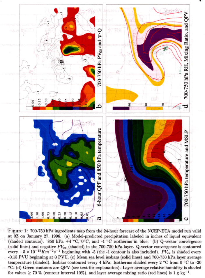
The ingredients-based methodology was applied to forecasting winter season precipitation through the ingredients analysis tool. This tool combined diagnostics for assessing each ingredient into a systematic forecast technique. Q-vector convergence was employed to qualitatively assess quasi-geostrophic forcing for ascent. Saturated geostrophic equivalent potential vorticity, PV,,, was used to identify regions of conditional or conditional symmetric instability (CI or CSI). Relative humidity and mixing ratio quantified moisture availability, and atmospheric temperature was used for both a determination of precipitation type and as a means to assess the efficiency ingredient.
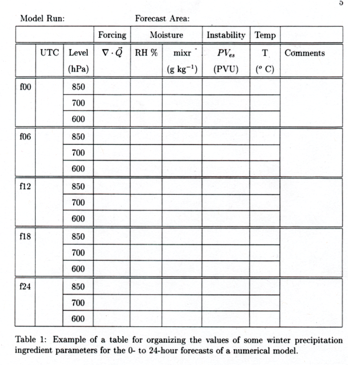
Isobaric ingredients maps (see Figure 1) were introduced to assist in the visualization of the ingredient parameters, and an ingredients table (see Table 1.) was used to organize the ingredients information from numerical model data for all forecast hours and in three isobaric layers (800-850 hPa, 700-750 hPa, 600-650 hPa). In some situations, the isobaric ingredients maps and ingredients table analysis at the three standard pressure layers do not fully capture the relevant distribution of the ingredients. In these cases, cross-sectional ingredients maps (not shown) provide a more complete picture of the vertical distribution of the ingredients.
The IBM can be used by itself to forecast precipitation duration, intensity, and type. It does not, however, independently provide an estimate of snowfall accumulation. This project also introduced an approach that combines the physical basis and flexibility of the IBM with the quantitative nature of a traditional forecast technique to make a preliminary prediction for snowfall accumulation. In this approach, the Garcia Method (Garcia, 1994) forecast for snowfall accumulation is used as the "normal conditions" forecast. Normal conditions for the Garcia Method correspond to moderate forcing for vertical motion, no instability, a 10:1 snow to liquid water ratio, and snow as the sole precipitation type. Thus, if the IBM indicates "abnormal conditions" (i. e., the potential for strong forcing, instability, or very cold surface temperatures), the Garcia Method-predicted snowfall accumulation should be increased. Garcia (2000) recommends a doubling of the inches of snowfall predicted by his original technique for heavy or convective snow events.
The utility of the IBM was illustrated for a number of Wisconsin snow events, including a case study of a poorly forecasted strong snow storm that affected Wisconsin on March 13-14, 1997. Together, the early onset of precipitation and the locally enhanced precipitation rates (as a result of convective snow) led to storm total accumulations of up to 30 inches. When applied to this case, the IBM provided an accurate description of precipitation duration, intensity, and type. The IBM identified a mid-level instability coincident with ample moisture, QG forcing, and an air temperature that could support maximum depositional growth of ice crystals. These processes were likely involved in an unanticipated snow swath that fell prior to the predicted onset of precipitation. Later in the storm, significant clues to the potential for additional convective precipitation were identified using the IBM. Using the 4:1 ratio of snowfall to mixing ratio suggested by Garcia (1999) for convective snowfall events, an accurate estimate of the snowfall accumulations was obtained.
3.2 Focus on the Instability Ingredient
A comprehensive investigation of instability, the most often overlooked ingredient in winter season mid-latitude cyclones, was performed. Saturated equivalent potential vorticity (PV,,) and equivalent potential vorticity (PV,) were employed as diagnostics for identifying regions of conditional instabilities (CI or CSI) and potential instabilities (PI or PSI), respectively. Through the analysis of numerical model data from Midwestern snow events, the mechanisms that influence the evolution of PV,, and PV, with time were explored. This analysis revealed that the evolution of PV,, and PV, in a mid-latitude cyclone is dominated by horizontal advection A comparison of the horizontal advection of PV, with the Eulerian change in PV, (APV,) revealed substantial agreement in structure and location of these features. A similar situation existed for the agreement between horizontal advection of PV,, and APV,,.
Although horizontal advection is the dominant mechanism by which PV, is changed, adiabatic generation, controlled by thermal wind advection of 0, also contributes to the reduction of PV,. The most negative AG occurred primarily upshear of the occluded thermal ridge and along the cold front of mature or decaying cyclones, where isopleths of layer-averaged 0, were rotated counter-clockwise with respect to contours of the isobaric thickness. No analogous adiabatic generation term exists for PV,,; however, the evolution of PV,, was shown to be influenced by what is termed the saturation deficit term. The saturation deficit term is generally of secondary importance to the advection of PVe,, though it may contribute significantly in the dry regions behind a strong cold front and upshear of a thermal ridge in mature and decaying cyclones where the relative humidity is low and horizontal temperature gradients are large.
These preliminary findings about the time tendencies of PV, and PVe, were not incorporated into the ingredients-based forecast tool; however, further investigation of the evolution of PV, and PVe, may have utility for the IBM. An understanding of the mechanisms that transport and generate regions of instability in mid-latitude weather systems would enable forecasters to anticipate the evolution of regions of instability given initial conditions including the PV, or PV,, field. For example, when numerical forecast model simulations are not verifying with observations, current analyses of winds, temperature and moisture parameters, and PV, or PV,, could be used to infer the short term evolution of regions of instability. Additionally, one could predict the location or intensity of areas of instability at times between the standard 6-hour numerical forecast model time interval by anticipating the behavior of PV, or PVe,.
4 Operational Elements of the Project
This project involved significant interactions with National Weather Service Forecast Offices. During the first year, through weekly visits to the Dousman, Wisconsin, forecast office, Suzanne became familiar with the demands placed on operational meteorologists and with their daily routines. An understanding of their approach to forecasting, and for their needs with respect to forecasting tools was acquired. This experience helped compile the following guidelines to aid in the preparation of an operational tool. A tool should be clear and simple and broken down into distinct steps. It should be well backed up with case studies and continually reinforced with real-time examples. It should be presented in a familiar context and available through a familiar interface. Most importantly, the tool should be concept-based and not a black box. 'Magic' formulae are too often trusted blindly and used beyond their capabilities. The forecaster must remain well informed of the limitations of the tool and must be able to recognize situations where further analysis is required. Suzanne also became familiar with software in operation at the NWSFO, including:
A web page was also part of this project:
http://www.speedy.meteor.wisc.edu/,swetzel/winter/winter.html
This page has been submitted to the COMET SOO Training Resource Center catalogue and is currently being adapted for NWS training by Scott Bachmeier (UW-Madison, SSEC) and Richard McNulty (NWS Training Center). The web page includes an introduction to the ingredients approach and a presentation of the theory behind each ingredient, a discussion for the ingredients analysis tool and access to 12z and Oz realtime runs of the ingredients maps (isobaric and cross-section) access to GEMPAK and NTRANS code to run the ingredients maps, case studies from 1995-1999, and a summary of traditional techniques for forecasting snow.
By the second winter season, the IBM forecast analysis tool was completed and running operationally at Dousman, WI on AWIPS and NTRANS, as well as at UWMadison, providing web access to the ETA model runs. A seminar titled "An Ingredients-Based Approach to Forecasting Winter Season Mid-Latitude Precipitation Systems" was presented by Suzanne at the NWS Central Region Winter Weather Workshop hosted by the Dousman NWSFO on November 3, 1999. Following this presentation, she was invited to present the seminar at other forecast offices:
Following are comments from Ed Fenelon, SOO, Marquette, MI NWS (through e-mail):
"I thought your talk at the winter weather workshop at WFO Milwaukee/ Sullivan was excellent. Your methodology for an ingredients based forecast brings together a number of excellent parameters and I thought summarized a number of important concepts forecasters must be aware of.''
"I think the concepts you cover provide an excellent perspective on uses of Q vectors and various forms of instability and PV, and I am very interested in having our forecasters apply the ingredients approach to winter storms in Upper Michigan.''
Examples of the operational applicability of this project
Excerpt from NWS Central Region Highlights, December 1999
Green Bay - WFO Green Bay hosted the office's Fourth Annual Winter Weather Seminar on November 19. Meteorologists from the media and the University of Wisconsin Green Bay joined NWS Green Bay staff for the 3.5 hour seminar. Following WCM Jeff Last's SWAP presentation, Suzanne Wetzel, research assistant at the University of Wisconsin- Madison Department of Atmospheric and Oceanic Sciences, delivered the feature presentation, "An Ingredients-Based Approach to Forecasting Winter Season Mid-Latitude Precipitation Systems." In her presentation, Suzanne reviewed five important ingredients involved in forecasting winter precipitation systems (vertical motion, stability, moisture, temperature, efficiency) and provided an organized method to diagnose these ingredients operationally, including several case studies illustrating her forecast methodology. Suzanne also provided Gempak scripts that can be used to apply her forecast methodology operationally. She has developed a comprehensive web page that outlines her ingredients-based approach.
Other Interest
In addition to the central region NWS interest in the ingredients approach, it has also been adopted for training and operational use at Kavoris, a private forecasting company in Minnesota, as indicated by the following e-mail:
Subject: Winter ingredients page
Date: Wed, 1 Mar 2000 15:13:41 -0600I am the Director of Training for Kavouras, Inc. and part of my job is to train our forecasters on the latest operational techniques. The information that you have made available is extremely helpful. I am especially interested in the stability parameter which we are not able to view anywhere else.
I found your winter weather ingredients page in early January and learned a considerable amount from what you have presented. During January and February there were several occasions where I was able to improve my forecast by looking at the ingredients. Items that were especially helpful were the instability parameter, Q-vector convergence and the temperature plots. There were several jet related snow events that were under forecast by the models, but these 3 ingredients lead me to increase the potential for snowfall (in saturated areas ). This system works. Thank you for your work and for making this data available.
Jeff Johnson
Kavouras, A DTN Company
Other individuals and organizations contacted me with interest in using the material presented on the winter ingredients web page, including:
Bill Sites, NWS National Operational
Hydrologic Remote Sensing Center, Chanhassen, MN
Chris Sisko, National Hurricane Center, Tropical Prediction Center, Miami, FL
Robert Dale, TV News Center Channel 6, WLNS Lansing, Lansing, MI
Walter Drag, NWS Taunton, MA
Ryan McCammon, NWS Dodge City, KS
Walker Ashley, University of Nebraska-Lincoln, Lincoln, NE
Marc Singer, St. Louis University and CIPS
Mace Bentley, Northern Illinois University
Area Forecast Discussions
The following excerpts from forecast discussions by forecasters at the NWSFO in Dousman, Wisconsin were written in 1999 and 2000 following the introduction of the ingredients analysis tools into the forecast office.
AREA FORECAST DISCUSSION
NATIONAL WEATHER SERVICE MILWAUKEE/SULLIVAN WI
330 AM CST WED DEC 15 1999
THE INGREDIENT ANALYSIS TOOL INDICATES 2G/KG MIXING RATIOS IN THE SE
CORNER OF WI WITH SOMEWHAT LESS TO THE WEST WITH ONLY LGHT QG FORCING. NO
INSTABILITY NOTED THUS XPCTG 1-3 INCHES ACRS THE CWA. BUFKIT SOUNDINGS SHOW
ALL SNOW WITH THIS EVENT.
- Written by John Haase
AREA FORECAST DISCUSSION
NATIONAL WEATHER SERVICE MILWAUKEE/SULLIVAN WI
258 PM CST MON JAN 3 2000
WETZEL FCST INGREDIENTS MACROS ON AWIPS SHOW Q VECTOR CONVERGENCE SUSTAINED
OVER ERN 2/3 OF CWA THRU 06Z AND LINGERING IN THE EAST TIL 12Z. SPEC HUMIDITIES
ARE IN THE 34G/KG RANGE. H8 TEMPS HANG IN THE OC RANGE OVER RACINE AND KENOSHA
CNTYS ... SO SNOW AMOUNTS MAY BE LIMITED BY MIX WITH RAIN. WL UP SNOW ACCUMULATIONS
SLGTLY FOR IOWA ... SAUK AND MQT CNTYS. CURRENT BAND COULD LAY DOWN A FAST
I TO 2 INCHES BEFORE OOZ ... SO WL EXPAND THE RANGE SLGTLY.
- Written by Bob McMahon
AREA FORECAST DISCUSSION
NATIONAL WEATHER SERVICE MILWAUKEE/SULLIVAN WI
230 PM CST MON JAN 10 2000
ON WED ... AVN GETTING EXCITED WITH NEXT SHORT WAVE WITH THIS ONE GENERATING
DECENT ISENT LIFT AND STG WAA. USING THE FORECAST INGREDIENT ANALYSIS TOOL
SUGGESTS MDT FORCING WITH SPECIFIC HUMIDITIES INCRG TO OVR 2 G/KG. SOME
INSTABILITY ALSO SHWG UP ACRS IA BY 12Z WED
WHICH MAY TRANSLATE INTO SRN WI DURING THE DAY. WUD LIKE TO SEE ANOTHER MDL
RUN. 0 H8 LN RMNS OVR NRN IL BUT ? REMAINS WHERE STGST LIFT AND HVST SNOWS
OCCUR. MAY END UP N OF MKX CWA. FOR NOW WILL GO 50 POPS ON WED.
- Written by John Haase
AREA FORECAST DISCUSSION
NATIONAL WEATHER SERVICE MILWAUKEE/SULLIVAN WI
211 PM CST WED JAN 12 2000
NEW ETA MODEL PAINTING SNOWY PICTURE FOR TNGT AS IT DVLPS ANOTHER SURGE OF
MOISTURE INTO THE MID LVLS. 290K ISENT PROGS SHOWING MIXING RATIOS INCRSG
TO 2-3 G/KG AFT OOZ ... AS UPR LVL INSTABILITY DVLPS AS RRQ OF JET MAX
MOVES OVR SRN WI. THIS MOST APRNT BY LOOKING AT WETZEL INGREDIENTS AT 600
MB. MAX UVV VALUES OCCUR AT OOZ AND CONT INTO EVE HRS. LOOKS LIKE QUICK
HITTER AS DYNAMICS SHIFT EWD BY 06Z. PSBL PD OF 3-4 HRS WHEN SNOWFALL
WILL BE HEAVIEST.
- Written by Cris Garcia
AREA FORECAST DISCUSSION
NATIONAL WEATHER SERVICE MILWAUKEE/SULLIVAN WI
330 AM CST TUE JAN 18 2000
MDT Q-VECTOR CONVERGENCE AS SEEN ON THE FCST INGREDIENT ANALYSIS TOOL (FIAT).
SPECIFIC HUMIDITIES ARE ARND 1.5 G/KG WITH TMPS PROFILE INDICATING A SNOW/WATER
RATIO OF 15:1 OR 20:1. MDL QPF'S ALSO IN THE . 10 TO .25 RANGE. SOME INSTABILITY
HINTED IN SW WI. TIME SECTIONS SHOW THAT THE BULK OF LIFT/DEEP LAYERED MSTR
IS WED AFTN UNTIL ABOUT 6Z THU. ALL THIS POINTS TO A 2-4 INCH SNOWFALL
BY THE TIME IT ENDS LATER THURS NGT WITH POTENTIAL FOR 5 INCHES IN OUR WRN
CWA. BULK OF THIS STILL IN XTND PART OF FCST SO WILL BEEF UP WORDING FOR THAT
AND INCR POPS SOMEWHAT FM PRVS FCST.
- Written by John Haase
AREA FORECAST DISCUSSION
NATIONAL WEATHER SERVICE MILWAUKEE/SULLIVAN WI
312 PM CST SAT JAN 29 2000
USING WETZEL INGREDIENTS APPROACH ... SERN WI HAS MODERATE FORCING
TONIGHT WITH Q-VECTOR DIVERG VALUES OF MINUS 5 TO MINUS 6 IN LAYER BETWEEN
850 AND 700. SOME INSTABILITY AT 650 TO 600 MB IN CROSS SECTIONS OVER SRN
WI LATE TNT AND SUNDAY MRNG. AS MENTIONED BEFORE, WE HAVE 2 GM/KG UP TO 700
MB IN SRN WI FED BY SE WINDS FROM IN AND OHIO AREA. RH VALUES OF ARND 90 PCT
ALSO SHOW UP FROM SFC TO 700 MB ACRS SRN WI WHERE CLOUD TEMPS ARND MINUS 15.
SO EXPECT RAPID ICE CRYSTAL GROWTH OCCURRING DURING PERIOD OF BEST FORCING.
EXPECT PERIODS OF MODERATE SNOW FOR SEVERAL HOURS 09Z TO 15Z TIMEFRAME ...
THUS ADVISORY.
- Written by Rusty Kapela
AREA FORECAST DISCUSSION
NATIONAL WEATHER SERVICE MILWAUKEE/SULLIVAN WI
200 PM CST THU FEB 10 2000
PERSISTENT PCPN OVR NERN CWA PARTLY THE RESULT OF STEADY FORCING UNDER RR
QUAD OF UPR JET. WETZEL INGREDIENT SCHEME SHOWED THIS ABOUT AS PERFECTLY
AS COULD BE EXPECTED. H7 AND H8 LVLS SHOWED ATMOSPHERIC INSTABILTY ... OR
A MAXIMA OF SATURATED GEOSTROPHIC EQUIVALENT POTENTIAL VORTICITY ... WITHIN
THE REGION OF FORCING AND COINCIDENT WITH ENOUGH MOISTURE TO PRODUCE THE AFOREMENTIONED
PCPN.
- Written by Steve Davis
AREA FORECAST DISCUSSION
NATIONAL WEATHER SERVICE MILWAUKEE/SULLIVAN WI
335 AM CST TUE FEB 15 2000
ALL NCEP MDLS CONT TO TAKE TRACK OF SFC AND MID LVL LO CENTERS ACROSS CNTRL
WI DURING THE DAY. BEST Q VECT CONVRG AND STRONGEST UVV/S TARGETING NRN WI
... ALONG WITH HIER MID LVL MOISTURE. OUR CWA WILL SEE A SHOT OF WAA PCPN
THIS MORNING ... WITH ANOTHER CHC OF PCPN AS VORT PASSES THRU LT AFT INTO
THE EVENING ... MAINLY EAST. LOW LYRS SLOW TO MOISTEN UNTIL LATE THIS AFTERNOON
... WITH INCREASING S TO SWRLY FLOW. WETZEL INGREDIENTS CHARTS SHOW
850 TO 700 MB LYR RE-MOISTENING AFTER INITIAL ISENTROPIC PUSH ... AHD
OF MID LVL LO ON 40 TO 50 KT LOW LVL JET.
- Written by Bob McMahon
AREA FORECAST DISCUSSION
NATIONAL WEATHER SERVICE MILWAUKEE/SULLIVAN WI
250 PM CST WED FEB 16 2000
HV SEEN NCEP HVY DISCUSSION AND GRAPHICS BUT THEY APPEAR TO SET-UP TOO
FAR TO THE NORTH INTO WI WHEN THE SYSTM DYNAMICS WUD FAVOR NRN IL. STG FORCING
GRAD ON NGM SHOWS UVV +16 AT ORD THAT DROPS TO +7 AT MKE ... WHICH IS STILL
RESPECTABLE. WETZEL INGREDIENTS KEEP MOST SIG INSTBLTY S OF WI THRU
EVENT.
- Written by Cris Garcia
AREA FORECAST DISCUSSION
NATIONAL WEATHER SERVICE MILWAUKEE/SULLIVAN WI
1112 AM CST THU FEB 17 2000
WETZEL INGREDIENTS OFF ETA STILL SHOWS BEST FORCING REMAINS ALONG WI/IL
BORDER AND S. BUT MIXING RATIOS INCR TO 3-4 G/KG ALONG BORDER AND NR
2 G/KG ALONG NRN PORTIONS OF CWA BY 12Z. MEANWHILE UW-NMS MODEL APPRS
TO FAVOR BEST FORCING JUST N OF WI/IL BORDER WITH SIMILAR MIXING RATIOS. FEELING
IS SRN WI HAS BEST TEMP STRUCTURE FOR HVY SN ... AND NO MXD PCPN IS EXPECTED
TO HOLD AMTS DOWN.
- Written by John Kowaleski
AREA FORECAST DISCUSSION
NATIONAL WEATHER SERVICE MILWAUKEE/SULLIVAN WI
330 PM CST FRI FEB 18 2000
LF QUAD OF JET WHICH HELPED SN TO INTENSIFY THIS MORN AND EARLY AFTN IS QUICKLY
MOVING E. MOST SN BANDS OVR CWA SHOWG DIMINISHING TREND
AS VORT PULLS AWAY ... AND TROWEL/DEFORMATION ZONE SLIDES E. A FEW SN BANDS
OVR NRN IL STILL LOOK HEALTHY AND SHLD CLIP THE FAR SE THIS EVE. A CLOSE-UP
LOOK OF THE VIS LOOP INDICATES MUCH OF THIS IS INSTABILITY INDUCED. WETZEL'S
INGREDIENTS SHOWS SOME PVU IN THE 650- 600MB LAYER ON THE UW-NMS
MODEL. SN SHLD PERSIST INTO THE EVE OVR FAR SE ... BUT GRADUALLY DIMINISH
AS ALL THE ABV MOVS E.
- Written by John Kowaleski
AREA FORECAST DISCUSSION
NATIONAL WEATHER SERVICE MILWAUKEE/SULLIVAN WI
243 PM CDT FRI APR 7 2000
300 MB JET MAX (115 KTS) NOTED EARLIER OVR SRN NEB CONTS TO PROGRESS TO THE
EAST INTO NWRN MO. JOHNSTON SRN EDGE ENHANCEMENT SETTING UP ON SATELLITE IR
PIX LOOP OVR SRN WI. IN RESPONSE SNOW AREAS OVR CWA HV BEGUN TO INCRS IN CVRG
AND INTENSITY ON RADAR PAST HR. FOR THIS REASON AND PROGGD WETZEL INGREDIENTS
HV DECIDED TO HOLD ONTO PRESENT WARNING AND ADVY ZN CUTS IN SPITE OF FACT
THAT SNOW HAS NOT ACCUMULATED MUCH DURG THE DAY DUE TO WARM GRD AND LACK OF
VRY COLD AIR. HWVR ... 850 MB TEMP PROGS DROP -4 TO -6 DEGREE ISOTHERMS
INTO SRN WI BY OOZ TNGT ... DCRSG TO -6 TO -8 BY 03Z. BESIDES BEING THE EMPIRICAL
SWEETSPOT FOR HVY SNOW IT ALSO COMES DURG MORE FAVORABLE NIGHTTIME HRS. BUT
FEEL THAT REDUCTION IN SNOWFALL AMTS IS JUSTIFIED DUE TO MELTING AND COMPACTING.
MOST ACCUM PRSNTLY ON GRASSY AREAS WITH WET ROADS.
AREA FORECAST DISCUSSION
NATIONAL WEATHER SERVICE MILWAUKEE/SULLIVAN WI
1126 AM CDT FRI APR 7 2000
CURRENT CONDS PLUS ARRIVAL OF NEW ETA MODEL HAS PROMPTED REEVALUATION OF WINTER
STRM WRNG CONFIG. PRESENT WIND DOPPLER INFO SHOWS 300 MB JET MAX CUTTING ACRS
SRN NEB WITH CIRCULATION SPINNING UP OVR SRN IA. WETZEL INGRED OFF NEW
ETA HIGHLIGHTING SRN WI WITH BEST QV CONVRG AND INSTBLTY ... ESPCLY OVR SERN
CRNR OF CWA. SFC LO IS PRETTY FAR S AND NOT XPCTD TO BE A BIG PLAYER IN
SNWFALL TOTALS BUT WL BE WITH INCRSG WINDS LTR THIS AFTN AND TNGT. SNOWFALL
FCST COUNTING ON CONVECTIVE TYPE DVLPG WITH COUPLED JET AND UVV 10-15 UNITS.
AREA FORECAST DISCUSSION
NATIONAL WEATHER SERVICE MILWAUKEE/SULLIVAN WI
330 PM CDT SUN APR 9 2000 SINCE BULK OF SN SHLD OCCUR OVRNIGHT MON ... NO
SOLAR RADIATION WILL MELT SN ... SO ACCUMS APPR LIKELY DESPITE WARM GROUND.
WETZELS INGREDIENTS OFF THE ETA AGAIN POINTS TO THE AREA NEAR THE BORDER
FOR THE MOST SIGGY AMTS. WL LEAVE FOR NEXT RUN TO DETERMINE AMTS AND IF
ANY HEADLINES ARE NECESSARY.
AREA FORECAST DISCUSSION
NATIONAL WEATHER SERVICE MILWAUKEE/SULLIVAN WI
330 PM CDT MON APR 10 2000
CNFLNT UPPER JET WILL BRING INCREASING UUV ACRS, SRN WI TNGT. WETZELS INGREDIENTS
METHOD SHOWS ONLY VERY WEAK Q-VECTOR CONVERGENCE AND INSTABILITY. MODELS
HAVE BEEN SHOWG SIMILAR TREND...
BACKING DOWN ... ON WHAT NOW LOOKS LIKE A RATHER DISORGANIZED SYSTEM. WL LEAN
TOWARD A WEAKER ETA. NRN AND SRN SHRT WAVES NOW MERGE OVR SRN LWR MI ... WITH
MAIN SRN BRANCH ONLY SKIMMING FAR SRN PORTIONS OF CWA. THIS LEAVES BEST PCPN
CHCS S OF THE BORDER. STILL ... WL CONT LIKELY POPS ... BUT TRIM BACK ON SN
AMTS TNGT.
- Written by John Kowaleski