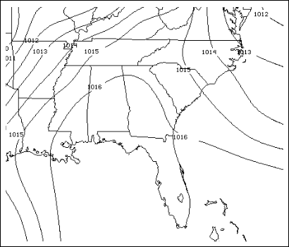
Figure 1. Composite sea level pressure for 19-21 June 1998 1200UTC, the peak in the daily fire frequency.
1. PROJECT OBJECTIVES AND
ACCOMPLISHMENTS
In response to the catastrophic 1998 Florida wildfires and the prolonged activity of the last two years, new emphasis has been placed on fire weather forecasting. A better understanding of how the atmosphere, and its interactions with other environmental factors, influences fire initiation and evolution will save lives, property, and natural resources. This study focused on the role of lightning, sea-breeze convergence, precipitation, large-scale circulations, and fuel-type in fire initiation and spread. Eight episodes with significant change in number and/or acres of daily fires were chosen for the study.
1.1 Major Accomplishments
OBJECTIVE 1. Determine the diurnal circulation migration cycle, low level moisture trends, convective instability, initiation of convection, attendant precipitation, downdrafts, and lightning
Large-scale environment: The synoptic environment provided the first indicator for wildfires across Florida. An atypical, predominant surface high-pressure area had settled over the southeastern US and the Gulf of Mexico causing rather dry airflow into the fire areas from the north and northwest (e.g., Fig.1).
Low-level moisture trends: The synoptic environment led to a sharp decrease in moisture in the mid-lower atmosphere and, with each dry surge, progressively less moisture to modify the subsiding air. The result was a period of low relative humidity, high temperatures and record drought particularly in north-central and northeastern FL. Six of the seven Florida climate divisions were among the top ten driest in 104 years (NCDC).
Diurnal circulation migration cycle: In 1998, prevailing westerlies drove the western sea breeze far inland while the eastern convergence zone hugged the coastline (Fig. 2). This was in contrast to the normal Florida summer climate regime, under which predominant easterlies propel the eastern sea breeze front toward the west sea breeze front, where the two converge to create a thunderstorm and flash density maximum over west central Florida.
Lightning:
The tendency for the eastern sea breeze front to remain nearly stationary led
to initiation of convection, lightning strikes, and fires just inland of the
coast. Across the state, lightning was the primary (31%) ignition source and
lightning fires covered 79% of the total acres burned during 1998. Although
dry conditions prevailed across much of the state, fires and lightning were
highly varied in time and space with the most numerous and largest fires occurring
in northeastern Florida during the last two weeks of June (Fig. 3). Not surprisingly,
daily frequency of cloud to ground flashes and fire starts were positively correlated
(R2 = 0.76). While high flash density is a necessary condition for fire initiation,
it is not sufficient to cause rapid combustion and is also not well correlated
to fire area. Fuel moisture, fuel continuity, and ignition processes also influence
combustion rate.
It is worth noting that negative flashes started approximately 85% of the lightning fires between 25 May and 4 July 1998; however the ratio of fires to flashes was higher for positive flashes across the state (238 flashes were within 800m of 192 fire locations). However, peak current and multiplicity were poorly correlated with daily fire frequency and area.
Precipitation
Radar analyses indicated the prevalence for most fire initiation to occur along
the periphery and outside of heavy rain areas. The precipitation, while welcome,
was accompanied by tremendous amounts of flashes and was sufficient to dampen
existing fires only briefly. Figure 4 shows the small amount of rainfall received
during three hours of thunderstorms and the subsequent resumption of fires,
widespread smoke, fog, and haze. Another contributing factor was the high concentration
of palmetto-galberry (southern rough) that ignites easily, burns at higher moisture
content, and is conducive to high rates of fire spread. Most fires including
the largest (61,500 acres) were the result of this fuel type ignition.
Convective Initiation, Instability, and Downdrafts: Convection developed along the sea breeze convergence zones primarily along the eastern coast of Florida. Under with weak surface pressure gradients, weak vertical wind shear, and CAPE (averaged for three north Florida stations) exceeding 1500JKg-1 on 19 June, it was not surprising that deep convection developed. Lightning strikes increased by an order of magnitude (to more than ten thousand flashes per day) and signaled the start of a two-week period with the most frequent fire starts and largest fires. Thunderstorm downdrafts played a significant role in spread of wildfires. This was particularly evident on 20 June when thunderstorm gusts were the major contributors to an almost nine-fold increase in fire area while the numbers of new fires and lightning strikes were similar to the previous day. JAX Radar velocity analyses, during the fires indicate downburst areas near fire areas. Direct effects were suppression in rain areas and flare ups outside of rain areas.
OBJECTIVE 2. Determine the Relationship between Sea Breeze Progression and Convective Development
Deep convection generated by sea breezes produced lightning that ignited a large percentage of the fires. In turn, those fires also modified the convection. For example, on 19 June, interactions among sea-breeze convergence, thunderstorm outflow boundaries, and existing fires formed a strong thunderstorm complex over northern Florida (Fig. 2).
Considerable contrasts were evident in the atmosphere between a day in which fires were suppressed (10 June) and two days with a dramatic expansion in the fires and acres (19-20 June). The suppression period was associated with passage of a significant trough, strong vertical wind shear, and intrusion of cooler air over northern Florida. In comparison, the major outbreak was characterized by high levels of instability and moisture for deep convection, a light surface flow, opposing sea breezes, and weak vertical wind shear. In the latter case, fire spread was closely tied to movement of thunderstorm downdrafts (gusts of 20-28kts, Fig. 4) because this very stable air can drive fires without regard to topography.
OBJECTIVE 3. Relate Quantitative Precipitation Estimates to Diurnal Circulations
Precipitation Distribution and Diurnal Circulations: By examining WSR-88D radar data from MLB and JAX, we were able to determine the distribution of precipitation relative to the sea-breeze circulations. We did not have access to the precipitation data from the Florida water management district therefore much of our rain gauge data came from hourly observation at the NWS stations and, for the case study, two FDOF sites in the worst of the fire zones.
OBJECTIVE 4. Compose articles and COMET Case Study (incorporate new knowledge to create a process for improving wildfire forecasts and guidelines for forecasters)
Case Study
Peak in daily fire frequency, largest increase in total fire area occurred during
19-21 June 1998. The case study includes a summary of case, fire characteristics,
weather forecasts, fire behavior forecast, satellite images, radar, surface,
upper air analyses, soundings, lightning distribution.
Dissemination of Results
The project has yielded one article published in a peer-reviewed/edited conference
proceeding, one article for resubmission to International Journal of Wildland
Fires (reviewers recommended more testing of new wildfire spread index to determine
long term use and applicability to other regions), and two manuscripts in preparation
(for submission to Monthly Weather Review and Weather and Forecasting). In addition,
the results of the study were disseminated in five conference presentations,
one workshop presentation, and one international seminar. New knowledge and
forecast tools were relayed specifically to NWS officers through a presentation
at the SRH Science and Operations Meeting, April 2002 and a lecture at the COMAP
Course for Science and Operation Officers, June 2002.
1.2 An Innovative Method for accomplishing Objective 4
New Wildfire Spread Index and the
Graphical Forecast Editor
Since our study showed that much Florida fire activity is related to quasi-stationary
deep convection (and attendant cloud-to-ground lightning), convergence, and
turbulent motion in the boundary layer, it is clear that fire weather indices
have to blend the effects of convective instability, turbulent motion, as well
as moisture availability. A new Wildfire Spread Index [1] takes the components
of the Bulk Richardson Number and extends its utility as a fire weather index
by incorporating static stability, surface and transport winds, and moisture
availability at the surface and in the mixed layer.
The NWS Tampa Bay Area is part of the FSL Rapid Prototyping Project (RPP) for the Graphical Forecast Editor (GFE) Suite. The GFE Suite is the future of forecasting in the NWS. The NWS created the Rapid Prototyping Project to speed up implementation of the fully operational IFPS. The RPP provides a direct conduit between forecasters and FSL developers through rapid turnaround of software. The RPP concentrates on three major areas: improved interactive tools, modernized products, and forecast process definition.
The GFE Suite provides scripting capability to develop custom algorithms (smart tools) for derivation of fields from the model data. The software then allows forecasters to graphically edit various standard model fields and the derived grid fields. Then the forecasters initiate programs to output the graphical forecasts in image form to the web. The software suite also provides a method for producing text forecasts. NWS Tampa Bay Area has spent considerable time developing GFE smart tools and scripts based on initial findings from this Comet funded project. GFE based products completed are:
Fire weather forecast text formatter
Weather Grids from wind regime based hourly lightning climatology
A full suite of graphical fire weather forecast parameters including:
New fields in development from this project include
Wildfire Spread Index/m2 = (Tsfc – Tmix) (Hmix)
(Vsfc2 + Vavg2) [1]
(Tdsfc
+ Tdavg)
Tsfc = surface temperature
Tmix = average temperature in the mixed layer (K)
H = mixing height (m)
Vsfc = surface wind velocity (ms-1)
Vmix = average mixed layer wind velocity (ms-1)
Tdsfc = surface dewpoint (K)
Tdmix = average mixed layer dewpoint (K)
g = gravitational constant (ms-2)
All of these products are just coming into use and are providing a jump-start to fire weather forecasting in Florida and other NWS offices.
1.3 Project Personnel and Responsibilities
Dr. Laing and Mr. Paxton were the Principal Investigators on the project. Dr. Laing supervised graduate students, analyzed satellite images and standard meteorological data, and conducted most of the Information System (GIS) analysis. Mr. Paxton developed many of the tools in the GFE that is now used to create fire weather forecasts in a format that is more suitable for adding GIS and other social data. He was also instrumental in the analysis of radar data and in identifying critical components that were lacking in fire weather forecasting. Dr. Scott Goodrick provided the fire data and information on fire management. Mr. David Sharp and Mr. Peter Blottman provided daily rainfall data from the Melbourne WSR-88D for the worst outbreak and the suppression case. Having first hand experience forecasting during the event, they offered valuable critique of our analyses. Mr. Charles Maxwell and Mr. Jim Brenner provided personal perspectives on fire management during June 1998. Dr. Pat Welsh provided radar data for Jacksonville.
Graduate Students
Pinak Nanvanty compiled data on cause and damages from several Florida Division
of Forestry (FDOF) and Federal Emergency Management Agency (FEMA) reports. From
these reports, cases were classified according to significant change in numbers
of fires and acreage burned. Donald Boehmer compiled lightning and fire characteristics
for input into a GIS. Russell Devane conducted analysis of sounding data, calculated
convective indices for all Florida stations, and identified flashes associated
with each fire. Kunal Gupta created plots of negative and positive flashes for
each day and also determined the lag times between fires and flashes for each
fuel type. Narayan Narvekar helped to create plots of surface and upper air
data including composite plots for peak and lull periods in daily fire frequency.
2. SUMMARY OF RESEARCH AND EDUCATIONAL EXCHANGES
2.1 COMET Course:
Laing, A. G., 2002: Fire Weather: Lessons from Florida. COMET COMAP Mesoscale
Meteorology Course, June 2002, Boulder, CO.
2.2 NWS Southern Region Science and Operations Officers Meeting:
Laing, A.G., C.H. Paxton, D. Sharp, P. Blottman, 2002: Florida wildfires: Environment and New tools. Summary of the COMET Outreach project, Jacksonville Beach, FL, April 2002.
2.3 Non-COMET Related Exchanges
1st Fire and Climate Workshop for
Southeast US
Dr. Laing was a member of the Steering Committee for the 1st Fire and Climate
Workshop for the Southeastern US held 25-27 June 2002 at the USF, St. Petersburg
campus. The workshop brought together climatologists and meteorologists (university
and NWS), and land managers (private and public) to focus on issues and challenges
related to fires and climate of the southeastern US. Dr. Laing summarized and
presented working group recommendations.
Student NWS Tours and AMS
Throughout the period of the study, USF students had many tours of the National
Weather Service office with co-PI, Mr. Paxton, acting as tour guide on several
occasions. Two USF undergraduate students were volunteer interns during the
period of study. NWS meteorologist Frank Alsheimer presented lectures on the
relationship between ENSO and Tampa Precipitation in the graduate course on
“Weather, climate, and society” and the undergraduate Climatology
course.
AMS Local Chapter
Students, NWS personnel, other professional meteorologists (including broadcast
meteorologists), and local weather enthusiasts participated in various activities
organized by the West Central Florida Chapter of the American Meteorological
Society (AMS). Mr. Paxton is the Chapter Vice President. Dr. Laing serves on
the Scholarship committee and was the banquet speaker in May 2002.
Air Chemistry Field Project
Both PI's participated in the Tampa Bay Air Chemistry Experiment (BRACE) held
in May 2002. Dr. Laing and researchers at the University of Miami provided detailed
forecasts for the NOAA Twin Otter aircraft tracking urban plume dispersal and
sea breeze circulation. Daily discussions with the NWS forecasters were very
valuable to the BRACE forecast team.
Museum of Science and Industry
Dr. Laing and Mr. Paxton are science advisors to the Museum of Science and Industry
(MOSI) Disasterville project, a joint effort with the Institute for Business
and Home Safety.
3. PRESENTATIONS AND PUBLICATIONS
3.1 Journal Articles:
Paxton, C. H. and A. G. Laing, 2002: A new index for fire danger assessment in Florida. Resubmission to the International Journal of Wildland Fires
Laing, A. G. and C. H. Paxton, 2002: Florida wildfires and the role of lightning in 1998. [To be submitted to Monthly Weather Review.]
Paxton, C.H., A. G. Laing, D. Sharp, and P. Blottman, 2002: The effects of diurnal circulations on the evolution of wildfires during 1998. [To be submitted to Weather and Forecasting.]
3.2 Peer-Reviewed/Edited Conference Proceedings
Laing, A.G. and C. H. Paxton, 2002: Assessment of wildfire environments in Florida during 1998. Papers and Proceedings of the Applied Geography Conferences, 25, 285-293.
3.3 Conferences:
Laing, A.G. and C.H. Paxton, 2002: "Fire Danger Assessment in Florida", Symposium on Environmental Applications, Amer. Meteor. Soc., Orlando, FL.
Paxton, C.H., and A. G. Laing, 2002: Florida Wildfires. WeatherFest, 82nd Annual Meeting of the American Meteorological Society, Orlando, FL.
Laing, A.G., C.H. Paxton, S. Goodrick, D. Sharp, P. Blottman, 2001: Florida wildfire initiation and environmental conditions during 1998. Preprints, 4th Symposium on Fire and Forest Meteorology, Amer. Meteor. Soc., Reno, NV.
Paxton, C. H., and A. G. Laing, 2001: ‘New tools for fire danger assessment in Florida. Preprint, 4th Symposium on Fire and Forest Meteorology, Amer. Meteor. Soc. Reno, NV.
Laing, A.G., C.H. Paxton, S. Goodrick, D. Sharp, P. Blottman, 2001: The mesoscale environment and lightning distribution during the 1998 Florida wildfires, Preprints, 9th AMS Conference on Mesoscale Processes, Amer. Meteor. Soc., Fort Lauderdale, FL.
Paxton, C. H., A. G. Laing, S. Goodrick, and C. Maxwell, 2001: Wildfire outbreak and suppression: Cases from 1998 Florida wildfires, Preprint, 18th AMS Conference on Weather and Forecasting, Fort Lauderdale, FL.
3.4 Workshops:
Laing, A. G., 2002: Florida wildfires and their relationship to lightning during 1998. NCAR/ESIG GIS Workshop, 12-14 August, Boulder, CO.
3.5 Seminar:
Laing, A. G., 2001: “Wildfire initiation and environmental conditions during the 1998 Florida wildfires”, Instituto Nacional de Pequisas Espacias (INPE), Sao Paulo, Brazil, 25 June 2001
4. SUMMARY OF BENEFITS AND PROBLEMS ENCOUNTERED
4.1 University of South Florida
Benefits
The COMET Outreach Program has been very beneficial to USF. Interaction with
NWS forecasters provides information about the daily operational needs, which
aided in focusing research at USF. The support of COMET provided the means
for Dr. Laing and USF students to become intimately acquainted with local meteorological
issues. The success of those relationships has fostered an atmosphere of cooperation
in various projects. For example, the recent air chemistry field project included
researchers from three USF colleges, the NWS, and University of Miami.
The success of this current project has led to other proposal submissions to expand our understanding of wildfire spread in an operational mode. During the course of this study, our findings became more important as wildfires plagued Florida during 1999 and 2000 although not to the extreme as 1998. Those seasons offered the opportunity to understand how fire agencies and emergency managers are using NWS products in daily operations.
In addition to the close ties developed with the NWS, the project has led to interaction with the forestry services in the Southeastern US and other fire-related decision makers. Dr. Laing has gained insight into the forecast and fire management process and has become involved in a broad effort to understand the environments of fires in the Southeastern US. Since becoming aware of the tremendous risk to the population and environment, Dr. Laing has become an advocate for incorporating more Geographic Information Systems (GIS) into fire weather forecasts, which will make the forecasts more valuable to fire and emergency managers.
Problems Encountered and Resolution
We encountered problems gaining access to the high-resolution rainfall data
from the Florida Water Management Districts. Without that data, we determined
the distribution of precipitation for our cases from the Melbourne and Jacksonville
WSR-88D radar precipitation totals and base reflectivity patterns as well as
hourly station observations.
One major problem encountered was having a single student dedicated to the project. Due to a family health crisis, the student initially scheduled to work on the project during Fall 1999 was unable to participate. Another student appointed to the project in July 2000 withdrew from the university in October 2000 because of personal and health-related problems. In lieu of a single student to work with the project, the project was completed with assistance from graduate student hourly assistants from the departments of Computer Science and Information Systems.
4.2 National Weather Service Partner
Many benefits have resulted from this collaboration. These include developing a terrific working relationship with Professor Laing and incorporating new data sets into the analysis and forecasting process. Of particular value were the Florida Agricultural Weather Network observations, the Climate Diagnostic Center Online Data analysis and visualization system, and lightning climatology. Most significantly, we developed new fire weather forecasting techniques using the Interactive Forecast Preparation System Graphical Forecast Editor described in Section 1, Objective 4.
Figure 1. Composite sea level pressure for 19-21 June 1998 1200UTC, the peak
in the daily fire frequency.
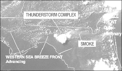
Figure 2. Visible satellite image, 19 June 1998 1932UTC
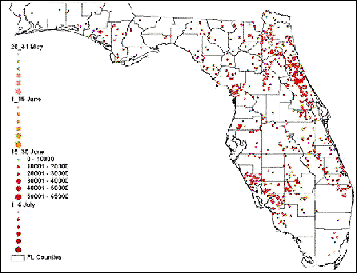
Figure 3. Spatial and Temporal Distribution of Fires (26 May - 4 July 1998)
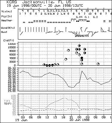
Figure 4. Meteorogram for Jacksonville from 0300 UTC 19 June - 1200 UC 20 June
1998.