Section I: PROJECT OBJECTIVES AND ACCOMPLISHMENTS
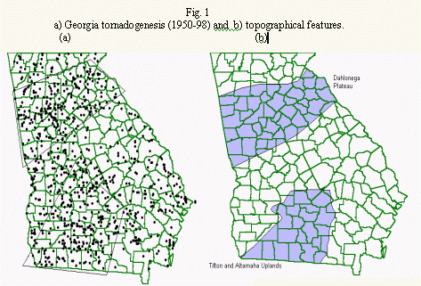
The project objective was to investigate a possible relationship between Georgia tornadogenesis and terrain features. Fig. 1a shows a plot of Georgia tornadogenesis points from 1950-98. This plot was generated using the NCDC (National Climactic Data Center) STORM DATA set. The data set was modified to include only the originating points of multi-touchdown tornado paths. The tornadogenesis plot visually suggests at least two favored regions (boxed) for tornado origination: 1) across the northern 1/3 of the state (basically north of Interstate-20 which runs west to east through metro-Atlanta), 2) in south-central and south-west Georgia. The plot also visually suggests an area generally unfavorable for tonadogenesis: east-central Georgia (south of Interstate-20 as it nears Augusta).
The two favored areas approximate large terrain features in the state. Fig. 1b outlines the Dahlonega Plateau and the Tifton and Altamaha Uplands. The plateau approximates the north-Georgia favored area; the uplands of South Georgia approximate the south-central and south-west favored area. This initial visual comparison suggests that tornadogenesis may be influenced by terrain features.
All parties in this collaboration felt it important to first address the possibility of a population bias in the tornadogenesis data. The area of increased tornadogenesis across northern Georgia is a densely populated portion of the state. The void of tornadogenesis across east-central Georgia falls in a region that is relatively sparsely populated. The NWS participants conveyed that a majority of the forecasters, in the Atlanta office, felt that population was playing a role in the tornado climatology of Georgia. Thus, we first investigated statistical relationships between population and tornadogenesis before attempting to answer any questions concerning terrain.
The population bias concern in the reporting of tornado occurrence has long been a focus of the literature. Abbey (1976) outlined a brief history of the major works concerned with population bias starting back in 1884. Early studies addressed relationships between the density of population and the reporting of tornadoes. Changnon (1982) suggested that rural population is the most useful statistic to use when assessing possible tornado bias in a data set.
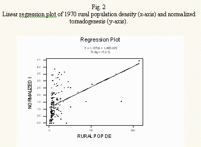
The Georgia Tech researchers initially cataloged the tornadogenesis climatology by county. For each county in the state the Georgia Tech researchers had the total number of tornadogenesis points calculated (from 1950-1998) and obtained 1970 census bureau statistics of: 1) rural population, 2) rural land area, 3) urban population and 4) urban land area. The Georgia Tech researchers decided to use 1970 statistics, as this was the rough mid-way point for the tornadogenesis data set. In a method similar to King (1997) the Georgia Tech researchers computed rural population density (rural population/rural land area) and urban population density (urban population/urban land area) for each county along with normalized tornadogenesis incidence for each county
![]()
where IN is the normalized incidence of tornadogenesis, T is the number of tornado occurrences and Ac is the county area. King (1997) found no relationship between population density and tornadogenesis totals in south-central Canada and our results were similar; no correlations were statistically significant. The highest correlation was a linear regression with normalized tornadogenesis and rural population density (r2= .17) shown in fig. 2. This correlation indicated a positive relationship between the two variables implying that as rural population density increased total tornadogenesis would increase. However, as fig. 2 clearly indicates the results are inconclusive with most of the data varying greatly over small rural population densities.
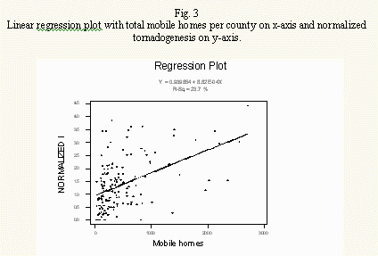
The NWS then suggested that we examine another possible predictor of bias: the economy of tornado destruction. A NWS forecaster commented that, though it seemed an irony, one would frequently "hear about tornado damage to mobile homes" every time a tornado was reported in Georgia. This irony may be explained by the increased vulnerability of mobile homes to the damaging high winds of tornadoes. Owners of mobile homes would perhaps more readily report tornado destruction or damage to officials. The Georgia Tech researchers obtained 1970 census bureau statistics on the number of mobile homes by county. Although the results indicated a higher correlation, it was still not statistically significant (r2=.24). Fig. 3 indicates that this was also a positive correlation, suggesting that as the number of mobile homes increased total tornadogenesis reports increased. Due to the weakness of the relationships investigated the Georgia Tech researchers proceeded to evaluate terrain influence without attempting to weight or normalize the tornadogenesis data set to population densities or other characteristics.
The Georgia Tech researchers collaborated with researchers from the University of Georgia's mapping sciences institute on the issue of terrain roughness. Roy Welch, institute director, was the initial contact. Welch used a digital elevation model to generate thousands of elevation points for each county. A mean elevation and standard deviation was computed for each county yielding measures of surface roughness due to terrain. This method was employed by the Georgia Tech researchers such that for each county in the state the following statistics were available: 1) total tornadogenesis, 2) mean elevation, 3) minimum elevation, 4) maximum elevation, 5) range of elevation, 6) standard deviation of mean elevation. The NWS and the Georgia Tech researchers used statistical software to conduct linear and non-linear regressions on the data set using the total tornadogenesis as the predictant and mean elevation, minimum elevation, maximum elevation, range of elevation, and standard deviation of elevation as possible predictors. The Georgia Tech researchers divided the data set up into counties with the highest tornadogenesis incidence and lowest tornadogenesis incidence. The Georgia Tech researchers sub-divided the tornadogenesis data set to run correlations with F0 and F1 tornadoes and F2 and greater tornadoes. No single, or group of, possible terrain predictors produced r2 values greater than .14.
The NWS and Georgia Tech researchers then determined that a scale smaller than county size would be more appropriate. A 5km by 5km grid was placed evenly over the state of Georgia. The following statistics were to be computed for each 5km by 5km grid: 1) total tornadogenesis from 1950-1998, 2) total population, 3) mean elevation, 4) maximum elevation, 5) minimum elevation, 6) range of elevation, 7) standard deviation of mean elevation, 8) the first derivative of the standard deviation of mean elevation with distance.
The Georgia Tech researchers made the computations and statistically analyzed relationships among the eight variables listed above. Of the eight variables one was found to be a significant predictor of tornadogenesis-surface roughness (the standard deviation of mean elevation). The data set was divided up into grids containing tornadogenesis points and grids without tornadogenesis points. Using the non-parametric Wilcox on two sample test, (Wadsworth, 1990), surface roughness correctly predicted which grids would have tornadoes and which would not with a T-Test significance of 0.78. The equation that describes the relationship between total tornadogenesis and surface roughness is given by
![]()
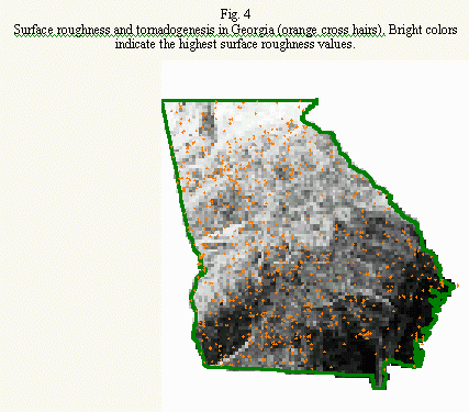
Where TG is tornadogenesis and Rs is surface roughness. This is an inverse relationship and suggests that higher surface roughness decreases the possibility of tornadogenesis. Fig. 4 is a plot of tornadogenesis overlayed on a contour map of Georgia surface roughness. Since this correlation was preformed on 5km by 5km grids equally spaced over the state there was no need for normalizing the tornado data.
This finding affirms a previous study made by Safford (1963) in Missouri. His research divided Missouri into 30 mile2 grids, with mean elevation change. He found a negative relationship between mean elevation and tornado incidence. Abbey (1976) would later suggest that Safford's work along with other terrain effect studies demonstrated tendencies but did not support "quantitative arguments."
The present collaboration provides quantitative evidence that a terrain influence does exist in Georgia. It has been demonstrated that surface roughness is a statistically significant predictor of the number of tornadogenesis points in Georgia for 5km by 5km grids.
SECTION 2: SUMMARY OF UNIVERSITY/NWS EXCHANGES
The major exchanges between the Georgia Tech researchers and the NWS regarding the collaboration are summarized above in section 1. The NWS, since this collaboration, has attended several seminars at the University regarding a proposed severe storms research center to be located on campus. The graduate student who plans to do a thesis on this collaboration has attended a severe weather seminar conducted last spring at the NWS by Donald Burgess.
Future collaboration will occur between the Georgia Tech researchers and the NWS as we attempt to publish our findings.
SECTION 3: PRESENTATIONS AND PUBLICATIONS
As a result of the time required to develop such a fine scale model of terrain, tornadogenesis, and population, the collaboration thus far has focused on research and not publication. An overview of this research will be presented as a poster session at the 20th Conference on Severe Local Storms September 11-15, 2000.
SECTION 4: SUMMARY OF BENEFITS AND PROBLEMS ENCOUNTERED
4.1 University
The University has received many benefits from the collaboration. The greatest benefit has been the professional interaction time with the graduate students working on this research problem and the forecasters at the NWS. The exchange of ideas concerning methods and approaches has been invaluable for our students. It has allowed real-world interaction and exposed our graduate students to the struggles involved in answering scientific questions. The Georgia Tech researchers have also greatly enjoyed the professional interaction over the course of the last year between the two institutions. Increased interaction is anticipated.
The initial poor correlation between terrain variables and tornadogenesis was the primary problem encountered during the collaboration effort. Once the original approach proved fruitless a more refined model was employed with much better results.
The research effort has also provided the Georgia Tech researchers with a very detailed climatology of tornadogenesis statistics for the state and some very detailed population statistics which will likely help in any future research efforts regarding tornadoes in Georgia. The Georgia Tech researchers have also gained a greater understanding of the quality of the dataset that makes up Georgia's tornado climatology. The collaboration has not indicated a significant population bias in tornado statistics for the state.
This study has demonstrated that the tornadogenesis data are not as precise as the terrain data. This has illustrated the need for improved methods for performing tornado surveys and storing the data. A demonstration study has been funded by the Severe Storms Research Center at the Georgia Tech Research Institute.
4.2 National Weather Service
An in-depth study of the distribution of tornadogenesis across Georgia was needed. By visual inspection of tornadogenesis maps it was obvious there was a variation across the state. This study, although not exhaustive, has shed important light on the subject.
Some of the benefits include:
The determination that there is no statistically significant evidence that population density biases tornadogenesis data set.
The determination of the influence of the number of mobile homes within in a county on the data set bias, which is also not statistically significant.
Confirmation of the negative correlation between tornadogenesis and terrain roughness opens the door to consideration for requiring higher thresholds for warning issuance when given storm parameters are observed over rugged terrain.
The demonstration that the county is not of a sufficiently small scale for analysis of tornadogenesis events. It appears that the 5 km scale is more appropriate.
NWS forecasters agree with the University that the research has provided very detailed statistics on the tornadogenesis climatology for Georgia. This, along with the detailed population data, should prove useful in future studies. One such study being considered by the local NWS office is how the population statistics affect severe thunderstorm warning verification values. It is believed that the reporting of severe weather (hail equal or greater than 3/4 inch, wind equal or greater than 50 kts) is much more dependant on population density than the reports of tornado occurrences.
The development of a fine scale model of terrain may prove helpful in the future implementation of locally run meso-scale atmospheric models. It may also prove useful in identifying, on a smaller scale, areas at increased risk of flash flooding due to terrain runoff.
Finally, perhaps one of the most important benefits has been the increased collaboration between the University and the NWS. Hopefully this will carry over into the collaboration between the Severe Storms Research Center at the Georgia Tech Research Institute, the NWSFO, Atlanta, and the NSSL
References:
Abbey, R.F., 1976: Risk probabilities associated with tornado windspeeds. Proc. Symp. On Tornadoes: Assessment of Knowledge and Implications for Man, Lubbock, TX. Texas Tech University, 177-236.
Changnon, S.A., 1982: Trends in tornado frequencies: Fact or fallacy. Preprents, 12th Conf. On Severe Local Storms. San Antonio, TX. Amer. Meteor. Soc., 42-44.
King, P., 1997: On the Absence of Population Bias in the Tornado Climatology of Southwestern Ontario, Weather and Forecasting, 12, 939-946.
Safford, A., 1963: The influence of terrain on the frequency distribution of tornado and hail occurrence in the central Midwest. Saint Louis University.
Wadsworth,
H.M., 1990: Handbook of statistical methods for engineers and scientists. New
York: McGraw-Hill.