
Expanding Weather Data’s Potential: 3D-PAWS Data Workshop
Over 350 of our 3D-Printed Automatic Weather Stations (3D-PAWS) span across more than 20 countries, providing meteorological agencies with on-demand access to live data. Currently, these agencies are only scratching the surface of what this massive collection of data can do for their communities. That’s why our team is developing our new 3D-PAWS Data Workshop.
Weather Data, Empowered
Data from our 3D-PAWS is a powerful resource for meteorological services in data-sparse regions. From helping meteorologists track mesocyclones and create accurate flash flooding forecasts in Barbados, to enhancing early warning systems to mitigate food insecurity in several African countries, 3D-PAWS data has proven instrumental in helping communities protect lives and livelihoods.
But what if it could do even more?
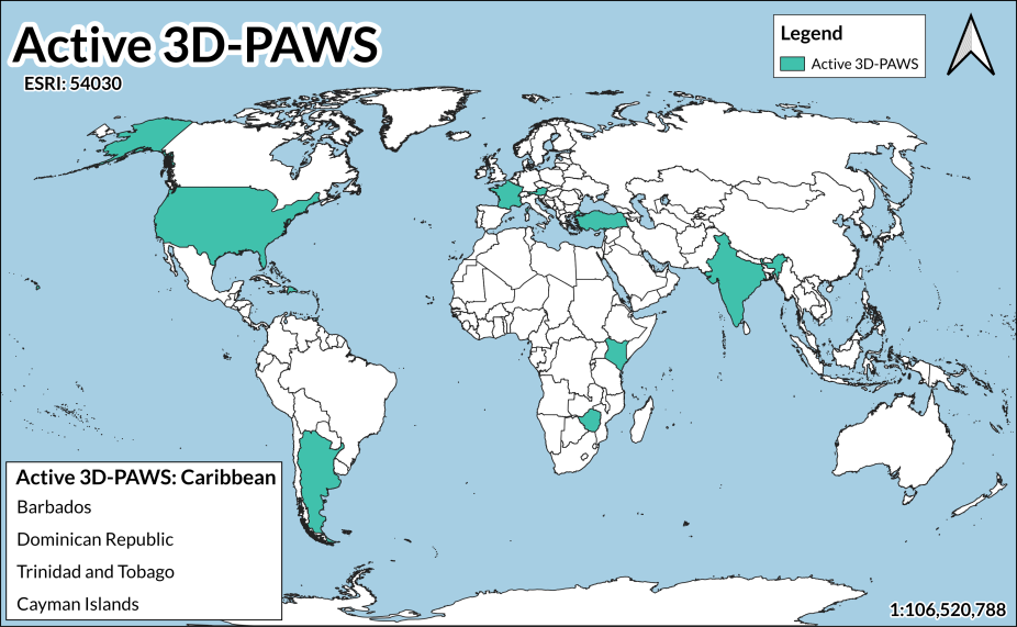
A map of the 20+ counties with active 3D-PAWS stations as of November 2025.
Amplifying Data and Its Usage
This question was central to the creation of COMET’s 3D-PAWS Data Workshops, a project started by Paul Kucera, late Assistant Director of COMET / Director of the COMET Innovative Capacity Development Program (ICDP). These workshops will expand our 3D-PAWS training offerings beyond the fabrication and installation of stations to center on greater data applications.
Currently, the data component of 3D-PAWS training focuses on managing data networks and accessing live data via cloud services. This training enables agencies to use their data for a nowcasting model of weather forecasting, focused on timely and localized forecasting.
With the development of the 3D-PAWS Data Workshops, agencies will learn how to retrieve their rich stores of data, interact with it, and develop applications tailored to the needs of their communities.
What is 3D-PAWS?
For the weather data-lovers who found this post and want to know more about 3D-PAWS, below is a quick overview. For those seeking to 3D-print your pet’s pawprints, this post will be far less useful (but we hope you’ll stick around!).
3D-PAWS (3D-Printed Automatic Weather Station) is an initiative to provide low-cost, reliable, and easy-to-maintain environmental observation platform solutions. A typical station measures air temperature, pressure, and humidity; wind speed and direction; and precipitation. Because the system is modular, stations can be customized with additional sensors to measure water level and flooding, air quality, soil moisture, and temperature to match local monitoring needs. Check out our 3D-PAWS manual to dive into sensor fabrication, data access, and more! Learn more about the history of 3D-PAWS here.

From left to right: (1) A standard 3D-PAWS unit; (2) storm gauge sensor; (3) snow depth sensor; (4) 3D-PAWS with a wet bulb globe temperature sensor.
Better Forecasting Capacity for Complex Terrain
Those living in small regions with diverse terrains, such as a transition from mountains to flat plains, know that calm weather can rapidly change to hazardous conditions. Weather forecasting is especially complex for these regions, which sometimes lack the data needed to detect and warn communities of impending weather hazards. Here are a few ways 3D-PAWS helps:
- 3D-PAWS provides more in-situ (on-the-ground) data to compare with satellite and radar imagery.
- The more dense the observations, the more complete the picture of the forecast environment
- In-situ data helps you verify what you think may be happening from looking at satellite or radar data.

An example of how data from 3D-PAWS is used to improve weather forecasting products.
Red Lake Nation College and COMET Pilot the First 3D-PAWS Data Workshop
The enhanced in-situ data offered by 3D-PAWS is one of the reasons members from the Red Lake Nation College (RLNC) in Red Lake, Minnesota, teamed up with COMET to pilot the first 3D-PAWS Data Workshop.
For one week in June 2026, Wendy Greenberg, RLNC professor and grants proposal writer, and RLNC’s dean, Tami Nendick joined COMET scientists Brianna Smith, Rebecca Zieber, Bryan Guarente, and Erin Houlihan, and COMET engineer Will Nicewonger at the COMET office in Boulder, Colorado, to develop, test, and iterate on teaching methods.

COMET Engineer, Will Nicewonger, shows data workshop participants how to access the 3D-PAWS data logger.
A Mission-Driven Collaboration
While future audiences for these data workshops will be forecasters and emergency managers at meteorological agencies with a network of stations across countries with 3D-PAWS, the team felt it was important to bring in the expertise and perspectives of the RLNC participants to inform the key components of the workshops.
“Collaborating with Wendy and Tami, who have a wealth of experience working with students and navigating the data challenges faced by Tribal Nations, provided us with instructional strategies and data use perspectives that are vital to the mission of these workshops,” said Brianna Smith. “Providing data ownership and enhanced data training to data-sparse communities was a passion of Paul [Kucera] that we share across the team.”
Key Takeaways
The pilot workshop provided several lessons learned as the team begins the next phase of development. One important takeaway from our RLNC partners was the benefit of using data from their own 3D-PAWS sensors for the training.
“Getting to see what we could do with the data from our own sensors at RLNC was exciting,” said Tami Nendick. “What really stood out was the potential for the data to further strengthen our community’s relationship to and knowledge of our land.”
Using their own data also expands their understanding of the physical hardware that they built prior to the data training, and how their community can develop an end-to-end approach to managing their stations, the data collected, and its applications.
“I’m excited to bring the ideas from this workshop to our students,” said Wendy Greenberg. “Developing new applications for our data will be a valuable opportunity for them and a great way to give back to the community hosting our stations.”
For the COMET staff, the workshop provided valuable lessons learned on how our partners can use 3D-PAWS data and how we can use a modular approach to meet the data needs of varying audiences.

Participants fabricated, built, and installed 3D-PAWS stations at Red Lake Nation College in 2025. A year later, participants used the data collected from these units for the 3D-PAWS Data Workshop pilot training.
What’s Next?
Equipped with the insights from RLNC and the key takeaways from the pilot workshop, the team is currently developing the next iteration of the workshop. This involves incorporating a modular approach to accommodate the unique needs of various stakeholders in addition to determining the best delivery methods for the workshop.
As a next step, the COMET team plans to conduct a needs assessment that will better help us tailor 3D-PAWS data workshops for international partners. The team also hopes to look for other opportunities to work with Tribal Colleges and Universities in the future.
Learn About Our Innovative Capacity Development Program (ICDP)
Want to learn more about COMET's Innovative Capacity Development Program? Check out the ICDP website here!
Once there, you'll learn about how ICDP provides innovative instrumentation, end-to-end early warning support, and more!